I love the limitless variety of the Cairngorms, and the way the inextricable links between history and landscape can enhance a day’s walk.
Today was to be one of those days, as Neville and I explored the Braes of Glenlivet. Only a short drive from Tomintoul, this secluded area offers some splendid walking, enhanced by a feeling of real connection with those who made their lives here over the centuries.
Starting from East Auchavaich near the end of the Chapeltown road, we were straight into local history, as we initially followed the Malcolm Gillespie trail, named after a well-known exciseman of the 18th Century.
After around 30 minutes we crossed the bridge at Ladderfoot and turned sharp right, following the east bank of the Ladder Burn. This was the start of the historic Ladder route, linking Glenlivet with Donside to the south.
The track soon narrowed, rising steadily across the steepening hillside.
The conditions were distinctly muggy as we trudged upwards, with the burn now sparkling far below. After crossing the steep-sided nick of the Allt nan Clach burn, the grassy ramp of the final stretch of ascent lay steeply before us. At last the first faint stirrings of a cooling breeze reached us, and before too long we reached the crest of the ridge.
The Ladder route continues straight ahead from here, dropping south-east towards Donside. Another day, perhaps. We turned right, and over the minor summit of Dun Muir.
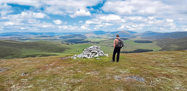
From here, our main objective of Carn Mor was clearly visible ahead. Keeping to the crest of the ridge, we descended slightly then climbed through peat hags before the final rise to the summit, with its trig point. At 804 metres, Carn Mor is a Corbett and the highest of the Ladder Hills.
Visibility was exceptional today. In our “other” lives, Neville and I are volunteer rangers with the Cairngorms National Park, and we were keen to test (or perhaps, show off…) our mountain identification skills. Below us lay the great bowl of the Brae of Glenlivet, stretching towards the Cromdale Hills. A glimpse of the Moray Firth, and the unmistakable fin shape of Ben Rinnes. The bulk of Corriehabbie Hill across the river Livet. The Buck, and even Bennachie silhouetted in the distance. The distinctive cone of Mount Keen, and then Lochnagar with a wisp of cloud obscuring its summit.
And ahead of us, the tor-studded summits of the eastern Cairngorms, with the last few snow patches glinting in the sun.
Pretty good all round!
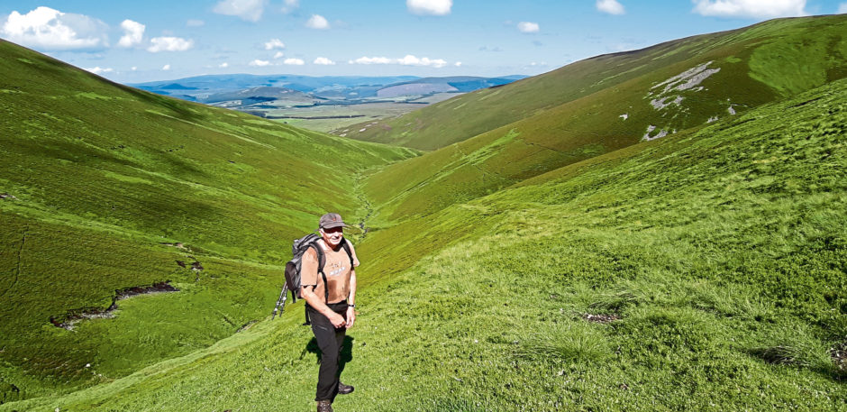
The ridge stretched SSW ahead of us, a splendid walk over wind-clipped grass, flecked with moss and bear berry. We made our way to the summit of Carn Liath before retracing our steps for 500 metres towards an obvious rocky outcrop marking the descent route. The going was rougher now, as the ridge lost height, and swung left with good views down to the 19th Century crushing house of the Lecht mine.
Reaching two prominent cairns, we paused to take in the views down into the Braes, and back along our route. Then, after a steepish descent over rough tussocky ground, we reached a vehicle track past the ruined Clash of Scalan.
A few more minutes and we reached Scalan, with its seminary and mills tucked away in this remote corner of the hills.
In the 18th Century, the College of Scalan trained young men for the priesthood, hidden away from the religious persecution of the times. The building is open to visitors, and gives a very atmospheric insight into the daily lives of those young men. It certainly wasn’t a cushy regime, as rules included rising “in summer at 5 and in winter at 6”.
In front of the seminary lie two fine old watermills, currently being renovated by the Tomintoul and Glenlivet Landscape Partnership.
A remarkable site, and well worth a visit in its own right.
A few more minutes through the fields took us to the road end. Several oyster-catchers circled as we reached the road, and, passing the distillery, returned to the car.
THE FACTS
- Route: Braes of Glenlivet loop
- Distance: 16 km Ascent: 540m
- Time: 5-6 hours
- Difficulty: A moderate hill walk, partly on clear tracks. Full hill-walking gear and navigation skills required.