It is a long drive up Glen Esk to the road end but I have never tired of this lovely Angus glen.
After the car park, the glen splits into two tributaries, Glen Lee and Glen Mark. This walk goes up the latter, following a good track for three kilometres to the Queen’s Well.
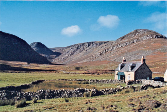
It is an easy stretch to cycle, and I leave my bike at a stand of pines beside the lonely stone house called Glenmark. It is an impressive spot with steep, bare crags on each side.
On my first visit I wondered what the house was used for, and my question was answered when a ghillie emerged from its yard leading a sturdy grey pony, saddled and ready for a deer carcase. No brightly coloured Gortex clothing for him, he wore a traditional flat cap and tweeds. His steady pace, aided by a tall walking stick, saw him quickly enter the shadowed, rock-walled gorge of the Water of Mark.
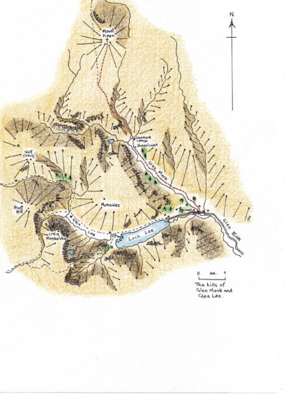
You do not follow in the ghillie’s footsteps on this walk, instead taking the path that winds up the east side of the glen, at first along the line of the Ladder Burn. It is an excellent track, one of the area’s ancient drove roads which can be followed all the way to Ballater in the north.
Before long the gradient slackens and you are on the high, windswept plateau of the Mounth. Turn off the drove road and take the good path up the cone-shaped summit of Mount Keen. The very top is a granite tor on which sits an old triangulation pillar. Another, smaller, tor lies to the north and can provide better shelter for a lunch stop.
It is an interesting picnic spot, with views of 360° and for many miles. On clear days a walker can pick out Bennachie in the north, the sea beyond Stonehaven in the east, the Angus hills to the south, Lochnagar in the west and, towering over all, the massive wall of rock which is Ben Avon in the north-west.
On one occasion, a storm formed on Ben Avon’s summit and spilled down to be caught by the powerful wind and blown straight towards us. By the time it hit Mount Keen, there were only ragged remnants, enough to make a perfect rainbow which bathed the summit in stripes of purple, blue, green, yellow, orange and red light. We stared, transfixed, until the colours disappeared along with the tatters of cloud which rushed towards the sea.
If you are lucky to have a fine day, you could consider a detour on the way back to explore some of this wonderful area. West of the house at Glenmark, the Water of Mark is lined by tall cliffs and hidden in them is Balnamoon’s Cave. Or, just before the car park, cross the bridge and turn into Glen Lee. A grim old castle stands at the point where the Waters of Lee and Mark join to become the Esk, its loopholes commanding the old road from Deeside to The Mearns. The first time I was at the castle a mature stag made his way along the fringe of the open birch wood next to the road, not in the least concerned by myself.
A kilometre further on brings you to the wave-lapped shores of Loch Lee, which fills the whole floor of the glen. To the west rise steep crags, not unlike those in the upper reaches of Glen Mark, between which the Water of Lee runs down to feed the sparkling loch. I stood looking west feeling that there was much more to see in this quiet corner of the world and today, many visits later, there is still more to explore.
This walk is included in Jack Harland’s new book, Highland Journal 2, In My Stride, published by Troubador.
The route
- Directions: Turn off the A90 on the B966 for Edzell. Go through the village and follow the road for three kilometres to find the left turn for Glen Esk. Take this minor road to its end where there is a car park
- Distance: 19 kilometres
- Time: Six hours (using a mountain bike for the first section)
- Difficulty: A straightforward walk on good paths
- Map used: Ordnance Survey Landranger 44