Calendar An icon of a desk calendar. Cancel An icon of a circle with a diagonal line across. Caret An icon of a block arrow pointing to the right. Email An icon of a paper envelope. Facebook An icon of the Facebook "f" mark. Google An icon of the Google "G" mark. Linked In An icon of the Linked In "in" mark. Logout An icon representing logout. Profile An icon that resembles human head and shoulders. Telephone An icon of a traditional telephone receiver. Tick An icon of a tick mark. Is Public An icon of a human eye and eyelashes. Is Not Public An icon of a human eye and eyelashes with a diagonal line through it. Pause Icon A two-lined pause icon for stopping interactions. Quote Mark A opening quote mark. Quote Mark A closing quote mark. Arrow An icon of an arrow. Folder An icon of a paper folder. Breaking An icon of an exclamation mark on a circular background. Camera An icon of a digital camera. Caret An icon of a caret arrow. Clock An icon of a clock face. Close An icon of the an X shape. Close Icon An icon used to represent where to interact to collapse or dismiss a component Comment An icon of a speech bubble. Comments An icon of a speech bubble, denoting user comments. Comments An icon of a speech bubble, denoting user comments. Ellipsis An icon of 3 horizontal dots. Envelope An icon of a paper envelope. Facebook An icon of a facebook f logo. Camera An icon of a digital camera. Home An icon of a house. Instagram An icon of the Instagram logo. LinkedIn An icon of the LinkedIn logo. Magnifying Glass An icon of a magnifying glass. Search Icon A magnifying glass icon that is used to represent the function of searching. Menu An icon of 3 horizontal lines. Hamburger Menu Icon An icon used to represent a collapsed menu. Next An icon of an arrow pointing to the right. Notice An explanation mark centred inside a circle. Previous An icon of an arrow pointing to the left. Rating An icon of a star. Tag An icon of a tag. Twitter An icon of the Twitter logo. Video Camera An icon of a video camera shape. Speech Bubble Icon A icon displaying a speech bubble WhatsApp An icon of the WhatsApp logo. Information An icon of an information logo. Plus A mathematical 'plus' symbol. Duration An icon indicating Time. Success Tick An icon of a green tick. Success Tick Timeout An icon of a greyed out success tick. Loading Spinner An icon of a loading spinner. Facebook Messenger An icon of the facebook messenger app logo. Facebook An icon of a facebook f logo. Facebook Messenger An icon of the Twitter app logo. LinkedIn An icon of the LinkedIn logo. WhatsApp Messenger An icon of the Whatsapp messenger app logo. Email An icon of an mail envelope. Copy link A decentered black square over a white square.

New drone pictures by Dundee University scientist highlight melting glaciers in Iceland

Post Thumbnail

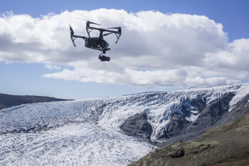
Stunning new footage shot from the sky is offering an invaluable insight into Iceland’s disappearing ice.

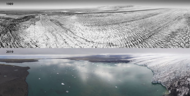
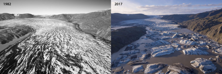
Old aerial images have been combined with modern-day drone photography to demonstrate the dramatic fashion in which some its largest glaciers are melting.

The groundbreaking 3D process has been created by Dundee University scientist Kieran Baxter, who has documented the scale of ice-loss on a group of outlet glaciers on the south side of Vatnajokull, one of the largest ice caps in Europe.

Dr Baxter, a researcher at the university’s Duncan of Jordanstone College of Art and Design, led the two-year project in collaboration with the University of Iceland and the Icelandic Meteorological Office, who conduct glacier monitoring in the country.

He said: “We have produced images that are engaging and easy to understand.

“It is important to show how climate change is physically and visibly affecting the region.

“This new method allows us to compose unique aerial views of past landscapes and to see how they have changed over the last 30 to 40 years.

“This period, which is within living memory for many people, has seen accelerated melt in south-east Iceland.

The scale of the ice loss is evident from these images. Pic: Dr Kieran Baxter, Dundee University.


“While we have a fantastic resource of mapping photographs from the 1980s, this method can also be applied to aerial photographs that are even older.

“The archives are huge and we have barely scratched the surface yet in terms of using them to better show how the warming climate is revealed in our landscapes.”

Vatnajokull ice cap has lowered by around 65ft on average every year for the last three decades.

The height of the outlet glaciers has plummeted even more, shrinking by up to 120-170ft. The study confirmed the ice has fallen by more than 1,300ft since 2000.

Dr Baxter used his system to create composite pictures which compare views from 1980s surveys to current photos captured with the help of the latest technology.

Aerial mapping photographs taken by the National Land Survey of Iceland were modelled in 3D using photogrammetry software.

While this process is routinely used by scientists to measure the historical ice surface, the models in this latest initiative have been aligned with contemporary drone photographs to highlight the impact of climate change on the region.

Dr Thorvardur Arnason, director of the University of Iceland’s Hornafjordur Research Centre, added: “Dr Baxter’s highly innovative work adds new dimensions both to the monitoring of glacier recession and to the communication of the severe impacts caused by catastrophic climate change on sensitive environments.

“The development of such novel vehicles for public outreach is of great importance in our attempts to understand and address the unprecedented scale, diversity and complexity of the ongoing climate crisis.”