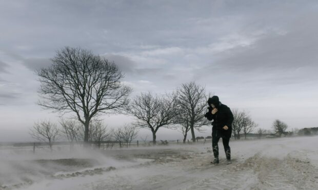
Snow has already been spotted on Scottish mountains, a few weeks earlier than last year, but there could soon be flakes on lower ground.
With one forecaster predicting “snow showers” before the month is out, meteorologists say is set to get much colder next week, and it is likely there will be snow on low lying ground.
But, it is unlikely that the cold snap will last as weather conditions are likely to get warmer again in October.
As Britons we are set to pass the equinox on Sunday – meaning the nights will be longer than the days – a cold front will sweep over the nation.
Always expect snow
Jo Farrow, from Netweather, said while meteorologists would always expect snow somewhere in Scotland before the end of September, this year may see snow on lower lying areas.

Speaking to Good Morning Scotland on BBC Radio Scotland, she said: “We pass the equinox early on September 23 so we are moving from the time of seeing more daylight to less daylight and longer nights
“It is going to get colder.
“It looks like on Monday the winds are going to switch round to a strong north-westerly flow.
She added: “Colder air coming in from Greenland.
“And it does look like on the weather charts that there will be some snow showers.”
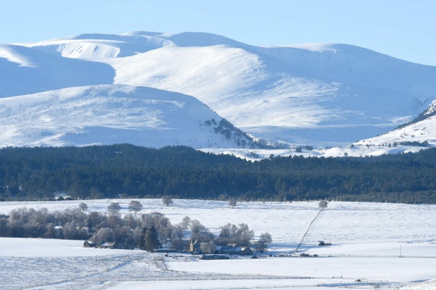
She continued: “On lower ground – on the Cairngorms already saw a dusting Thursday Friday, a little bit.
“Last year that did not come until later in the month, and people said that was quite late.
“So, you would expect to see a dusting on the mountaintops.
“But it looks like Monday into Tuesday it is going to be much colder. And another dusting for the mountain tops and into Wales and Exmoor.
“But you might see a wintery flurry going past.”
The Met Office said while it might be chilly, it did not go as far as to say there would be snow.
Temperatures ‘close to average’
A spokeswoman said: “A fine and dry start to the period for most but it will probably turn more unsettled, with a band of rain and cloud arriving in the northwest during Sunday and spreading quickly southeastwards.
“Winds generally light but becoming strong in the northwest later with gales or severe gales likely.
“After a chilly start, temperatures should be close to average, perhaps becoming cool.
“Through the remainder of September, conditions are likely to remain changeable with further frontal systems spreading from the west and northwest at times.
“The wettest conditions with periods of strong winds are likely in the west of the UK, with the driest weather in the southeast.
“Similar conditions are expected for the start of October.
“Temperatures becoming close to average once again, or perhaps just above average.”
And for a white Christmas?
We know it is really too early to last – and that there is always a chance of snow.
Website willigetawhitechristmas.com says that there is a 50% of snow in Inverness at Christmas.
But the Met Office said: “For most parts of the United Kingdom, Christmas is only at the beginning of the period when it’s likely to snow.
“We are more likely to see snow between January and March than in December, with snow or sleet falling an average 3.9 days in December, compared to 5.3 days in January, 5.6 days in February and 4.2 days in March.
“White Christmases were more frequent in the 18th and 19th centuries, even more so before the change of calendar in 1752 which effectively brought Christmas Day back by 12 days.
“Climate change has also brought higher average temperatures over land and sea and this generally reduced the chances of a white Christmas.”
The last widespread white Christmas in the UK was in 2010. It was extremely unusual, as not only was there snow on the ground at 83% of stations – the highest amount ever recorded – but snow or sleet also fell at 19% of stations.


Conversation