Calendar An icon of a desk calendar. Cancel An icon of a circle with a diagonal line across. Caret An icon of a block arrow pointing to the right. Email An icon of a paper envelope. Facebook An icon of the Facebook "f" mark. Google An icon of the Google "G" mark. Linked In An icon of the Linked In "in" mark. Logout An icon representing logout. Profile An icon that resembles human head and shoulders. Telephone An icon of a traditional telephone receiver. Tick An icon of a tick mark. Is Public An icon of a human eye and eyelashes. Is Not Public An icon of a human eye and eyelashes with a diagonal line through it. Pause Icon A two-lined pause icon for stopping interactions. Quote Mark A opening quote mark. Quote Mark A closing quote mark. Arrow An icon of an arrow. Folder An icon of a paper folder. Breaking An icon of an exclamation mark on a circular background. Camera An icon of a digital camera. Caret An icon of a caret arrow. Clock An icon of a clock face. Close An icon of the an X shape. Close Icon An icon used to represent where to interact to collapse or dismiss a component Comment An icon of a speech bubble. Comments An icon of a speech bubble, denoting user comments. Comments An icon of a speech bubble, denoting user comments. Ellipsis An icon of 3 horizontal dots. Envelope An icon of a paper envelope. Facebook An icon of a facebook f logo. Camera An icon of a digital camera. Home An icon of a house. Instagram An icon of the Instagram logo. LinkedIn An icon of the LinkedIn logo. Magnifying Glass An icon of a magnifying glass. Search Icon A magnifying glass icon that is used to represent the function of searching. Menu An icon of 3 horizontal lines. Hamburger Menu Icon An icon used to represent a collapsed menu. Next An icon of an arrow pointing to the right. Notice An explanation mark centred inside a circle. Previous An icon of an arrow pointing to the left. Rating An icon of a star. Tag An icon of a tag. Twitter An icon of the Twitter logo. Video Camera An icon of a video camera shape. Speech Bubble Icon A icon displaying a speech bubble WhatsApp An icon of the WhatsApp logo. Information An icon of an information logo. Plus A mathematical 'plus' symbol. Duration An icon indicating Time. Success Tick An icon of a green tick. Success Tick Timeout An icon of a greyed out success tick. Loading Spinner An icon of a loading spinner. Facebook Messenger An icon of the facebook messenger app logo. Facebook An icon of a facebook f logo. Facebook Messenger An icon of the Twitter app logo. LinkedIn An icon of the LinkedIn logo. WhatsApp Messenger An icon of the Whatsapp messenger app logo. Email An icon of an mail envelope. Copy link A decentered black square over a white square.

It will be pretty chilly for a while yet… But forecasters say warm weather isn’t far away

The Met Office are warning of snow later this week

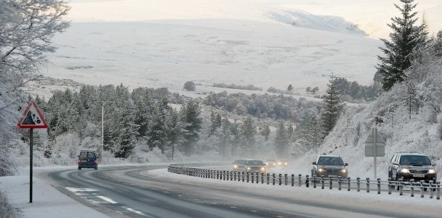
Freezing conditions are expected to continue this morning with motorists warned of treacherous roads as a result of plummeting temperatures.

Lows of -4C were forecast for Aberdeen city, shire and Moray this morning, with the far north-east forecast for a brief blast of snow and sleet.

And a Met Office yellow warning for ice will remain in place until 11am today with the forecaster warning of “difficult driving conditions”.

However, this weekend could bring with it much warmer conditions plus some sunshine.

Sub-zero conditions led to hazardous roads across the area yesterday morning, with regional lows of -4.9C recorded at both the Balmoral Estate and Braemar, whilst Fyvie Castle dropped to -4.8C.

However Kinbrace, in Sutherland, was named the coldest place in the UK yesterday with temperatures dropping to -12.4C.

Today melting snow and fresh wintry showers in parts of the north-east will combine and cause ice to form on roads, with frost also expected.

Meanwhile the Peterhead area could be hit with some overnight snow and sleet.

Speaking last night Met Office meteorologist, Emma Sharples, said: “There will be a few showers around and about on Tuesday night, but it is mostly drier conditions.

“Temperatures are expected to drop below freezing again. It will be somewhere between -1C and maybe -3C or -4C. There is a maximum temperature of 3C on Wednesday.

“But there should be a fair amount of sunshine around tomorrow for the whole of Aberdeenshire.

“For the far north-east and the coast there will perhaps be the odd wintry flurry of sleet or rain but Aberdeen should be sheltered. I don’t think it will be anything significant.”

He added: “Much of the same can be said as you go into Thursday. There will be a band of rain eastwards on Friday, which may turn wintry on higher ground.

“It will get milder at the weekend. I doesn’t look like this weather is going to continue. It does look like temperatures will recover towards the weekend on Saturday and Sunday. There is a maximum of 9c and 10C.”