As the Cold War intensified in the 1980s, the Soviet Union drew up plans to throw its military forces against key opponents including the United States and the UK.
It may never be known just how seriously they were intended but what has become clear is that Aberdeen and its famous harbour were identified by the superpower’s leaders as a choice target.
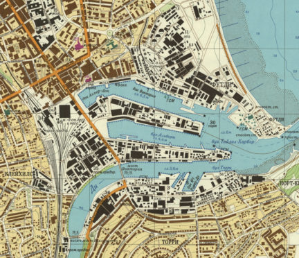
A painstakingly detailed map created by the Soviet Army shows how it researched and monitored the Granite City as it became Europe’s oil capital in the late 1970s and 1980s.
Names familiar to the city’s residents – including Torry, Kincorth and Footdee – are rendered in unfamiliar Russian on the map, alongside precise measurements for the bridges over the Dee, with the Victoria Bridge and Wellington Bridge having their lengths and widths accurately recorded.
The Soviets also pinpointed a set of 58 “important objects” and provided clues as to how they might attempt an invasion of the city in the event of war.
>> Keep up to date with the latest news with The P&J newsletter
Such detail is seen as evidence that the Soviet Union had agents operating in the city, feeding back detailed information to their eastern leaders.
The remarkable findings will be unveiled in a new book “Scotland: Defending the Nation” by Carolyn Anderson and Christopher Fleet when it is published next month.
And the authors told the Press and Journal yesterday that the Soviets drew up plans for invading Scotland as the Cold War intensified after Ronald Reagan became US president in 1980.
They said: “We were surprised by the amount of detail and the precision of the map, but then Russian military maps are striking to behold, impressive in their detail, and also quite frightening in equal measure.
“The wealth of information it includes would surprise anyone.”
The Soviets’ detailed description of Aberdeen and the surrounding area includes the statement: “The coastal area north from Aberdeen is suitable for amphibious landing.
“Numerous stone quarries, mainly of granite in Aberdeen suburbs, can be used as shelters.
“The landscape of Aberdeen’s suburban area represents partly open coastal flatlands with patchy hills, dissected by deep river valleys, which are the major obstacles for non-road mobile machinery.
“Mud season lasts from October to April and during this period, transport mobility is often hampered.”
The harbour was regarded as a key feature in the Russian report and it forms the main focus of the “Industrial and Transport Facilities” section of the lengthy document.
It adds: “Aberdeen seaport is the major maintenance base for oil deposits in the North Sea.
“There are berthing facilities on both of the Dee’s banks. Dockage facilities can provide the complete overhaul of vessels, including destroyers.”
The authors conclude their assessment with the chilling words: “It is clear the maps and descriptions are an immense repository of intelligence.
“They provide thorough supporting information for a possible invading or occupying army, as well as for a military campaign and combat operations.
“However, they are broader than this in scope and it is possible the maps could also have supported civil administration [of the region] after a successful coup.”
On December 25, 1991, the Soviet hammer and sickle flag lowered for the last time over the Kremlin and was thereafter replaced by the Russian tricolor.
Earlier in the day, Mikhail Gorbachev resigned his post as president of the Soviet Union.
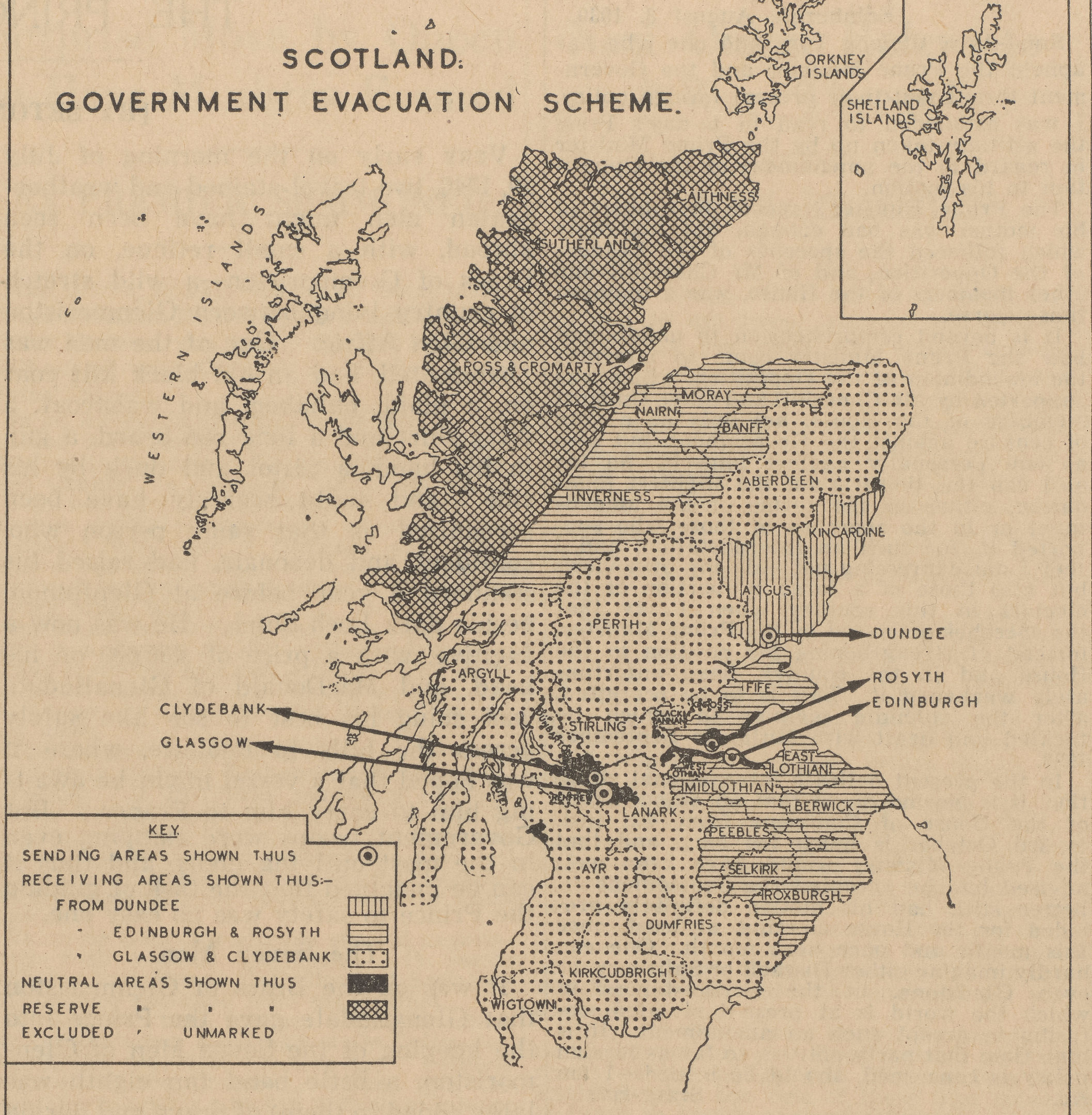
The book also includes an ‘Evacuation Map of Scotland’, which was released on September 5, 1939.
Mr Fleet said: “The evacuation planned to move 1.8 million people from the major conurbations and cities in Scotland out to rural areas over just two to three days.
“And here was a map of Scotland, which was barely the size of a postcard, with a few brief lines underneath it that calmly told everyone what was going to happen.”
The book will be published by Birlinn in November.
Foreign attacks
Aberdeen has long been considered one of the most strategic locations in the UK for foreign attackers.
As a former stronghold of Scottish manufacturing and due to its key position at the North Sea, the Granite City was heavily bombed by the Luftwaffe during the Second World War.
The terrible destruction came to a head on one particular night, April 21, 1943, when the city experienced its worst air raid of the war.
In less than an hour, German aircraft dropped 127 bombs, damaging or destroying more than 12,000 homes and killing 98 civilians and 27 soldiers.
Between 1940 and 1943, Aberdeen was the most frequently bombed city in Britain, reportedly earning it the nickname Siren City.
High explosive bombs were dropped frequently all around the harbour in an effort to hamper Aberdeen’s maritime forces,
Cluster bombs, phosphorus explosives, incendiary bombs and other weapons of war also caused havoc in the city’s industrial areas, including Broadford Works.