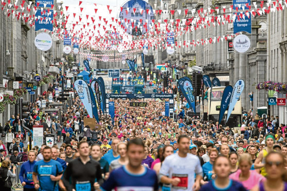
City council bosses have advised of road closures and restrictions during this Sunday’s Simplyhealth Great Aberdeen Run.
Major city streets will be closed for much of Sunday, with most closures coming into place at 8pm on Saturday night.
There will be a staggered reopening of roads throughout the day on Sunday from 12.15pm to 5.30pm.
Here is the list in full:
Road Closures from 8pm on Saturday:
Until 12:15pm on Sunday
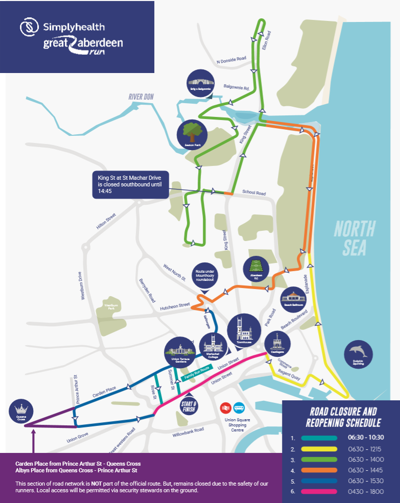
- Beach Esplanade, between York Street and the Beach Ballroom
- Beach Boulevard, between Links Road and the Beach Esplanade
- Links Road, between the entrance to the Beach Ballroom and the Beach Esplanade.
Until 2pm on Sunday
- King Street, between Regent Walk and A90, Parkway
- Balgownie Road from A956, Ellon Road to Balgownie Crescent
- Cottown of Balgownie for its entire length
- Don Street, Old Aberdeen, from the Brig o’ Balgownie to King Street
- The Chanonry, Old Aberdeen, between Seaton park entrance and St Machar Drive
- Seaton Drive, between King Street and the east gable of 2 Seaton Drive
- St Machar Drive, between Tillydrone Avenue and King Street
- Elphinstone Road, for its entire length
- Meston Walk, between Elphinstone Road and High Street
- High Street, for its entire length.
Until 2.15pm on Sunday
- Beach Esplanade, between the Beach Ballroom and King Street.
Until 2.45pm on Sunday
- Accommodation Road, Aberdeen, for its whole length
- Park Road, between Golf Road and the north gable of 53 Park Rd
- Roslin Street, between Seaforth Road and a point 10m south
- Urquhart Street, between Seaforth Road and a point 10m south
- Seaforth Road, for its entire length
- Urquhart Lane, between Seaforth Road and a point 10m south
- Errol Street, between Seaforth Road and a point 10m north of junction
- Urquhart Road – on either side between Hunter place and Urquhart Lane.
Until 3.30pm on Sunday
- Gallowgate, for its entire length
- Spring Garden, between Loch Street and Gallowgate
- St Andrews Street, between Blackfriars Street and Charlotte Street
- Upperkirkgate, for its entire length
- Schoolhill (including inset road)
- Rosemount Viaduct, between Schoolhill and Gilcomston Park
- Skene Street, between Spa Street and Carden Place
- Summer Street, between Skene Terrace and Skene Street
- Carden Place, between Skene Street and Queens Cross
- Albyn Place, for its entire length
- Rubislaw Terrace, between Albyn Place and Queens Terrace
- Rubislaw Place, between Albyn Place and Rubislaw Terrace
- Victoria Street, between Alford Place and Thistle Place
- Prince Arthur Street, between Carden Place and Albyn Place.
Until 5.30pm on Sunday
- Union Row, between Union Wynd and Union Street
- Diamond Street, between Union Street and Diamond Lane
- South Silver Street, between Golden Square and Union Street
- Springbank Terrace, north side, between Crown Street and Willowbank Road;
- Willowbank Road, south side, between Albury Road and Hardgate
- Willowbank Road, north side, between Hardgate and Holburn Street
- Rosemount Place, both sides, between South Mount Street and Skene Square
- St Swithin Street, both sides between Union Grove and Union Grove Lane
- Union Grove, north side, between St Swithin Street and the west gable of 240 Union Grove
- Beach Boulevard, Between Hanover Street and directly opposite its east junction with Wales Street
- Marischal Street, both sides for its entire length; Back Wynd for its entire length; Summer Street for its entire length.
You can also check the road closures on this map from Aberdeen City Council. For more information click here.
An Aberdeen City Council spokesman said: “We want to ensure any impact on Sunday is kept to a minimum and that those on the route have the necessary information to plan for the day.
“We advise anyone who needs to travel around Aberdeen on August 25 to check routes prior to setting out and plan journeys in advance.”
For public transport information, visit the First and Stagecoach websites.