A section of the A96 has been closed and the Scottish Environmental Protection Agency has put out flood warnings for 12 separate areas of the north-east after Storm Alex pummeled the region with rain overnight – and looks set to continue through Sunday.
Aberdeen City Council put a message on social media around midnight last night to say the major road, which leads from Aberdeen to Inverness, had to be closed at Forrit Brae near P&J Live due to flooding.
Pictures put online by the public last night show deep water covering the roadway, washing over the traffic islands and soaking into the grass verges.
People thinking of using that section of the route are urged to find an alternative route.
*** Flooding ***
We have closed the A96 at the bottom of Forrit Brae (near P&J Live) due to flooding. Many other roads have lots of surface water so please drive carefully. Please use an alternative route. pic.twitter.com/BKAFCXFVht— Aberdeen City Council (@AberdeenCC) October 3, 2020
The council warned people in Garthdee that they should expect to reach flood warning level at 11.45am with the peak at about 1pm.
At Deeside Holiday Park in Maryculter, flood warning level is expected to be reached at 1pm, with the focus mainly to the south side of the river.
Riverside Drive beside Bon Accord Glass is currently at warning level, and expected to peak at about 2.20pm.
Aberdeenshire Council, meanwhile, has put in place a temporary flood gate barrier at Kembhill Park in Kemnay and local teams are continuing to monitor water levels and close roads where necessary.
Their engineers are also carrying out safety checks at various bridges across the Rivers Don, Deveron and North Esk.
Riverside Drive is also closed between King George VI Bridge and Queen Elizabeth II bridge as a precaution.
Nine areas in Aberdeen and Aberdeenshire have been issued a flood warning by the Scottish Environmental Protection Agency (SEPA), indicating actions must be taken to protect lives and property.
They are:
- Stonehaven – Specifically Low Wood Road, Carron Terrace and Cameron Street, with the potential for flooding to properties in central Stonehaven
- Turriff – The Turriff wastewater treatment works and agricultural land along the river
- Milton and the Meadows – The northern part of Huntly and areas beside the River Deveron and its tributaries
- Maryculter – A precautionary warning for possible impacts at Deeside Holiday Park
- Kintore – Expected significant depth of water inundation on the B977 and surrounding agricultural land adjacent to the River Don, and a risk to Castle Hill and Kingsfield Road
- Kemnay – Properties in the Milton Meadows and Kembhill Park areas of the village are at risk, as is Milton Drive which may cause issues for vehicular access via Milton View
- Inverurie – The River Don will be close to the top of the flood bank at the football fields upstream of the B993 around 9am until early evening today
- Ballater – A precautionary warning regarding possible flooding impacts at the caravan park and properties at the lower end of Dee Street, with widespread flooding not expected in the area
- Aberdeen (Dee) – Due to high river flows on the River Dee, areas in and around Riverside Drive adjacent to Bon-Accord Glass are expected to experience floods overnight Saturday into Sunday for potentially an extended period
Sandbags have been made available by Aberdeen City Council for residents near the industrial properties, commercial properties and infrastructure in Garthdee or at-risk, which can be found at the Tullos depot.
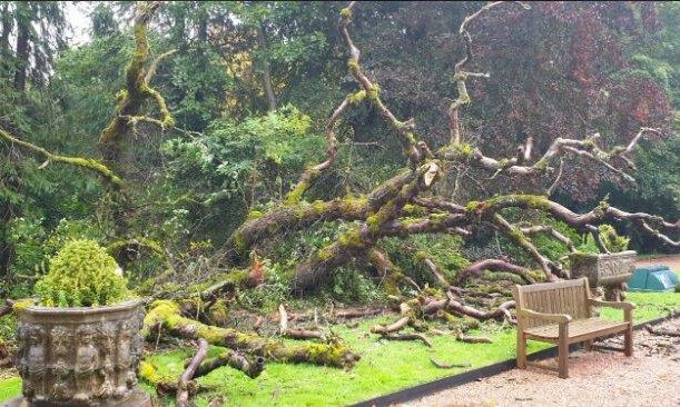
In the grounds of Fyvie Castle, the strong winds pushed over an 150-year-old elm tree, narrowly avoiding historic Victorian planters.
SEPA also issued three flood warnings for places in Findhorn, Nairn, Moray and Speyside:
- Aberlour, Craigellachie and Dandaleith – Agricultural land and low lying properties and roads are at risk along the Spey valley
- Boat O’Brig to Spey Viaduct – Agricultural land along the Spey valley from Rothes to the Spey Viaduct and low lying properties and roads
- Spey Viaduct to Spey Bay – Low lying areas are at risk of flooding from the Spey Viaduct to Spey Bay, and low lying properties and roads in Garmouth and Kingston are also at risk, including the B9015 Kingston Road