Calendar An icon of a desk calendar. Cancel An icon of a circle with a diagonal line across. Caret An icon of a block arrow pointing to the right. Email An icon of a paper envelope. Facebook An icon of the Facebook "f" mark. Google An icon of the Google "G" mark. Linked In An icon of the Linked In "in" mark. Logout An icon representing logout. Profile An icon that resembles human head and shoulders. Telephone An icon of a traditional telephone receiver. Tick An icon of a tick mark. Is Public An icon of a human eye and eyelashes. Is Not Public An icon of a human eye and eyelashes with a diagonal line through it. Pause Icon A two-lined pause icon for stopping interactions. Quote Mark A opening quote mark. Quote Mark A closing quote mark. Arrow An icon of an arrow. Folder An icon of a paper folder. Breaking An icon of an exclamation mark on a circular background. Camera An icon of a digital camera. Caret An icon of a caret arrow. Clock An icon of a clock face. Close An icon of the an X shape. Close Icon An icon used to represent where to interact to collapse or dismiss a component Comment An icon of a speech bubble. Comments An icon of a speech bubble, denoting user comments. Comments An icon of a speech bubble, denoting user comments. Ellipsis An icon of 3 horizontal dots. Envelope An icon of a paper envelope. Facebook An icon of a facebook f logo. Camera An icon of a digital camera. Home An icon of a house. Instagram An icon of the Instagram logo. LinkedIn An icon of the LinkedIn logo. Magnifying Glass An icon of a magnifying glass. Search Icon A magnifying glass icon that is used to represent the function of searching. Menu An icon of 3 horizontal lines. Hamburger Menu Icon An icon used to represent a collapsed menu. Next An icon of an arrow pointing to the right. Notice An explanation mark centred inside a circle. Previous An icon of an arrow pointing to the left. Rating An icon of a star. Tag An icon of a tag. Twitter An icon of the Twitter logo. Video Camera An icon of a video camera shape. Speech Bubble Icon A icon displaying a speech bubble WhatsApp An icon of the WhatsApp logo. Information An icon of an information logo. Plus A mathematical 'plus' symbol. Duration An icon indicating Time. Success Tick An icon of a green tick. Success Tick Timeout An icon of a greyed out success tick. Loading Spinner An icon of a loading spinner. Facebook Messenger An icon of the facebook messenger app logo. Facebook An icon of a facebook f logo. Facebook Messenger An icon of the Twitter app logo. LinkedIn An icon of the LinkedIn logo. WhatsApp Messenger An icon of the Whatsapp messenger app logo. Email An icon of an mail envelope. Copy link A decentered black square over a white square.

Severe weather warning for north-east as more snow forecast

Post Thumbnail

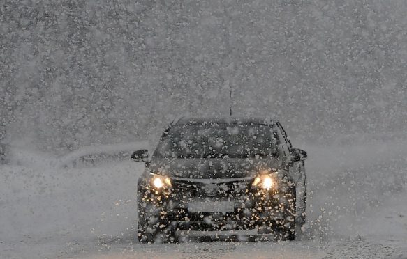
A warning for snow and ice is in place across the north-east with motorists warned of plummeting temperatures overnight.

Western Aberdeenshire and Moray is expected to be hit by snow tonight and in the early hours of Monday with ice also likely to form on many routes, leading to a Met Office yellow “severe” weather alert.

Snow and sleet showers are also forecast to move into the north-east, but the worst of this new blast of wintry weather was not anticipated to make it into the lower regions of Deeside and Donside, nor to Aberdeen.

However, in areas above 490ft, about two inches of snow is expected to fall, whilst the highest regions of Grampian could experience as much as four inches.

Braemar, Huntly and Tomintoul are all predicted to endure snowfall, whilst the likes of Ballater and Alford could also see some of the white stuff.

The warning was put in place at 3pm today and will remain in force until 10am tomorrow.

The Met Office’s chief forecaster said: “Wintry showers will continue this afternoon and overnight into Monday morning. Initially the showers will fall as sleet and snow above 200 metres, with temporary accumulations to lower levels away from western coastal districts.

“However, snow levels will rise slightly on Sunday night and accumulations are expected to become more confined to routes above 250m (820ft) to 300m (985ft) by Monday morning, where 2-5 cm (0.8-2in) will accumulate with 10cm (4in) possible over ground above 400m (1,300ft).

“Some drifting of the snow is possible in the strong westerly winds. Ice will also be a hazard on untreated surfaces even to lower levels.”