Calendar An icon of a desk calendar. Cancel An icon of a circle with a diagonal line across. Caret An icon of a block arrow pointing to the right. Email An icon of a paper envelope. Facebook An icon of the Facebook "f" mark. Google An icon of the Google "G" mark. Linked In An icon of the Linked In "in" mark. Logout An icon representing logout. Profile An icon that resembles human head and shoulders. Telephone An icon of a traditional telephone receiver. Tick An icon of a tick mark. Is Public An icon of a human eye and eyelashes. Is Not Public An icon of a human eye and eyelashes with a diagonal line through it. Pause Icon A two-lined pause icon for stopping interactions. Quote Mark A opening quote mark. Quote Mark A closing quote mark. Arrow An icon of an arrow. Folder An icon of a paper folder. Breaking An icon of an exclamation mark on a circular background. Camera An icon of a digital camera. Caret An icon of a caret arrow. Clock An icon of a clock face. Close An icon of the an X shape. Close Icon An icon used to represent where to interact to collapse or dismiss a component Comment An icon of a speech bubble. Comments An icon of a speech bubble, denoting user comments. Comments An icon of a speech bubble, denoting user comments. Ellipsis An icon of 3 horizontal dots. Envelope An icon of a paper envelope. Facebook An icon of a facebook f logo. Camera An icon of a digital camera. Home An icon of a house. Instagram An icon of the Instagram logo. LinkedIn An icon of the LinkedIn logo. Magnifying Glass An icon of a magnifying glass. Search Icon A magnifying glass icon that is used to represent the function of searching. Menu An icon of 3 horizontal lines. Hamburger Menu Icon An icon used to represent a collapsed menu. Next An icon of an arrow pointing to the right. Notice An explanation mark centred inside a circle. Previous An icon of an arrow pointing to the left. Rating An icon of a star. Tag An icon of a tag. Twitter An icon of the Twitter logo. Video Camera An icon of a video camera shape. Speech Bubble Icon A icon displaying a speech bubble WhatsApp An icon of the WhatsApp logo. Information An icon of an information logo. Plus A mathematical 'plus' symbol. Duration An icon indicating Time. Success Tick An icon of a green tick. Success Tick Timeout An icon of a greyed out success tick. Loading Spinner An icon of a loading spinner. Facebook Messenger An icon of the facebook messenger app logo. Facebook An icon of a facebook f logo. Facebook Messenger An icon of the Twitter app logo. LinkedIn An icon of the LinkedIn logo. WhatsApp Messenger An icon of the Whatsapp messenger app logo. Email An icon of an mail envelope. Copy link A decentered black square over a white square.

First-of-its-kind scheme encourages people to snap photos of coastline to track erosion

Post Thumbnail

The coastline around Stonehaven is one of the north-east’s most popular and frequently photographed areas of natural beauty.

Now, a new initiative will encourage people to snap pictures of the seaside in an effort to tackle the problem of coastal erosion.

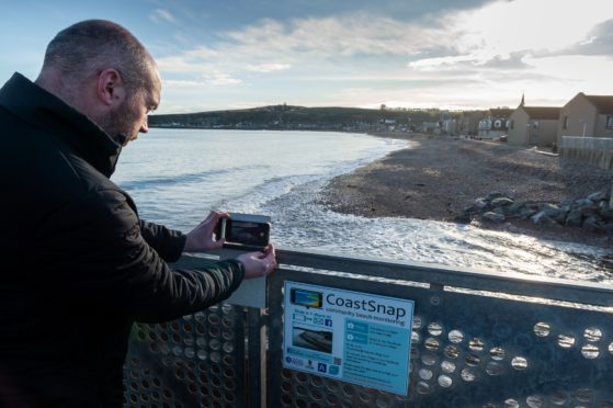
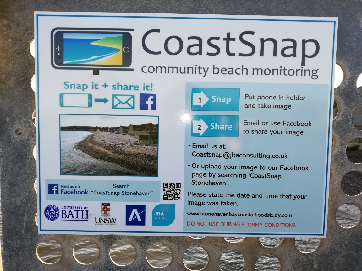
A purpose-built camera frame has been set up at the south end of the beachfront road, above the Cowie River, for people to take photos from the same fixed spot.

Images can then be uploaded to a dedicated Facebook page or sent via email, with a date and time, to eventually produce a time-lapse video of how the coastline is evolving.

The “CoastSnap” project is the first scheme of its kind in Scotland, and comes following warnings from experts that the north-east isn’t prepared for the potentially devastating effects of coastal erosion.

Stonehaven has been named as one of the towns which is potentially under threat.

Gavin Penman, Aberdeenshire Council’s projects manager, said: “Natural beaches form the first line of defence against high tides and stormy seas in many coastal towns all over the world.

“As sea levels are predicted to rise and storms get worse, understanding the behaviour of these natural systems has never been more important.

“I would encourage residents and visitors alike to take photographs to help us collect monitoring data.”

Aberdeenshire Council completed a study into the coastal flood and erosion risk within Stonehaven Bay last year.

The new measure has been developed in partnership with JBA Consulting, with the aim of better understanding beach behaviour and informing future decisions on how to best manage erosion.

Douglas Pender, of JBA Consulting, said: “Beach environments are under a variety of pressures, such as climate change and rising sea levels.

“By using this simple approach, it is hoped a vast amount of information can be gained which ultimately provides knowledge for coastal planners and managers.

“We understand this is the first of these coastal monitoring fixings in Scotland and, if the Stonehaven scheme is a successful in evaluating beach movement over time, we may consider other locations.”

More than 2,000 miles of coastline across Scotland is thought to be at risk of erosion through rising sea levels, with accompanying threats to roads and railways.

People can access the initiative via social media at www.facebook.com/CoastSnap-Stonehaven-100594964836035/ or on Twitter via @StonehavenSnap, while pictures can be emailed to to Coastsnap@jbaconsulting.co.uk