Thunderstorms are expected to hit areas across the north and north-east after weeks of sun and high temperatures.
Forecasters expect thunderstorms to hit most of the Highlands and Moray from 12noon today (July 27) until 10pm.
It is thought that the Inverness area and western Moray are at a higher risk of the thunderstorms, however, a thunder warning is in place for the majority of the Highlands and Moray.
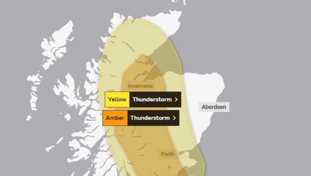
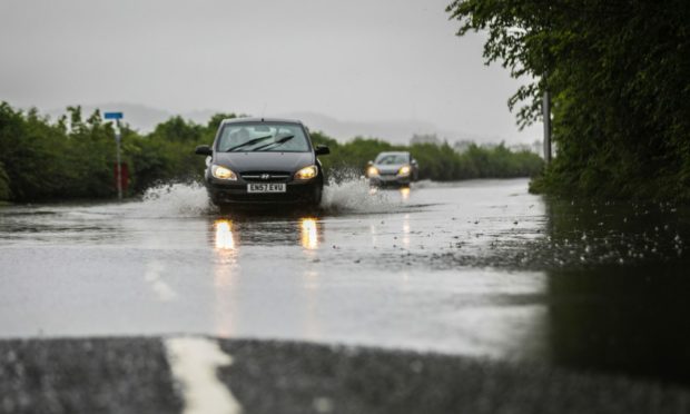
The Met Office warns that heavy thundery showers may lead to flooding and transport disruption across these areas.
Buildings may be damaged by flooding, lightning strikes, hail, or strong winds throughout the day.
A Met Office spokesperson said: “Showers will break out widely across much of Scotland from late morning, turning heavy in the afternoon.
“While many places will miss the heaviest showers, where they do occur 20-40 mm could fall in an hour with locally 60-80 mm in a few hours.
“Showers will start to merge to longer spells of rain in the evening, but easing in intensity.”
The Highland Council is urging residents to “be prepared” after the warnings for potential power outages and flash floodings. They have reassured that staff are closely monitoring the situation.
The executive chief officer for environment and infrastructure, Malcolm MacLeod said: “Our teams are closely monitoring the forecast and all warnings issued and are as prepared as they can be.
“If there are any impacts, staff are ready to help those most at risk, including vulnerable members of the community but we need householders and businesses to remain alert and ready to take actions which can help protect themselves and their property.”
Gullies in areas prone to flooding have been serviced and inspected and over the last few days and staff are prepared to respond to any impact with the deployment of sandbags and floodgates to vulnerable properties.
The council advise all householders and businesses to remain vigilant and to be aware of the warning, their own property responsibilities, and to take any actions they can to prepare.
Rain warnings
The Met Office has also issued a warning due to persistent rain in much of the Highlands, excluding the far north, and most of the north-east.
It extends from midnight on Wednesday until 6am on Thursday.
However, forecasters believe that from 6am on Wednesday until 6am on Thursday parts of the Highlands, including Ullapool, Alness and Inverness, and Moray have a higher risk of heavy and prolonged rainfall.
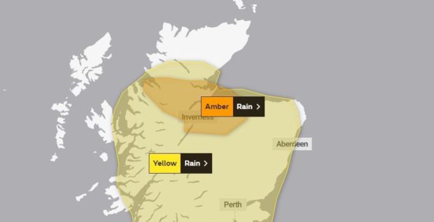
Persistent rainfall, which will be heavy at times, may lead to localised flooding and transport disruption.
The Met Office advised that some homes and businesses could be flooded, driving conditions may be difficult and there is a chance of possible power cuts.
Sepa has issued flood alerts across the majority of mainland Scotland starting from today due to heavy showers.
It is thought that the worst affected areas are likely to be Easter Ross and the Great Glen, Findhorn, Moray, Nairn and Speyside, with other areas of mainland Scotland being hit.
David Faichney, Sepa’s duty flooding manager explained: “Due to the nature of thundery showers, it’s hard to pinpoint exactly where will be worst hit, but what we do know is that it can happen quickly and can be highly localised.
“It’s important that those out and about, holidaying, engaging in activities near rivers and streams or out hillwalking are aware of the hazards and stay safe. Some rivers and streams can rise to dangerous levels very quickly, so avoid camping near water and be very mindful of conditions if considering activities such as swimming or canoeing.”
He advised people working and living in the affected areas to plan their journeys and be prepared with flood protection products such as sandbags.
Me Faichney added: “Extreme weather such as prolonged heavy rain following a period of warm, dry weather, is something we will see more of as our climate changes and these patterns become more common in the future.”