A huge landslide cut off an island community after days of heavy rain, with the north on alert for more weather-related chaos as it prepared for the onset of Storm Ali.
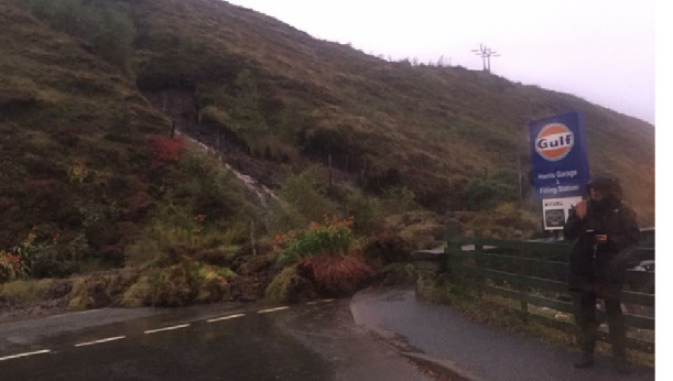
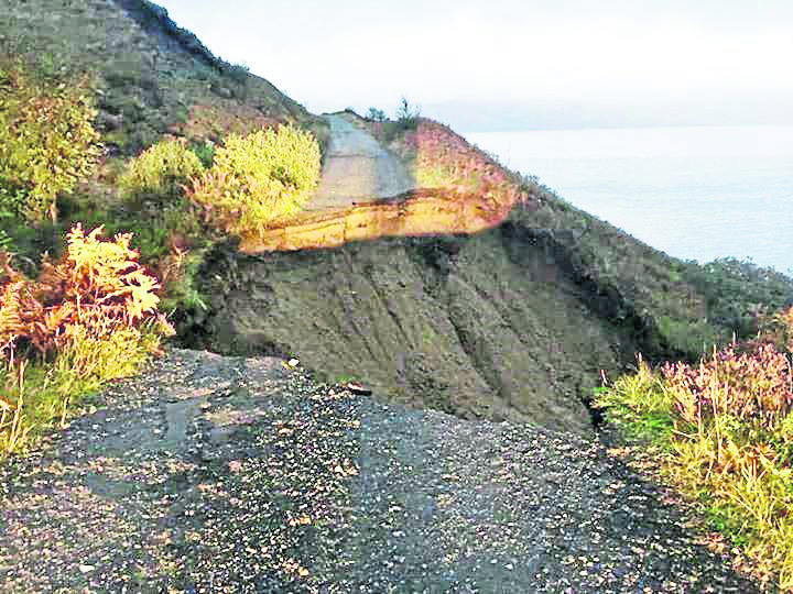
Tarbert on Harris in the Western Isles and communities south of the village were cut off as thick clumps of vegetation poured down the steep hill and blocked the main road opposite Harris Hotel.
The slip occurred on the A859 before dusk on Monday. Between the road closure and a stricken cargo ship preventing the ferry from berthing, Tarbert was inaccessible from land and sea overnight.
Yesterday one lane of the road had re-opened, however police said they feared there could be further landslides as the weather was due to worsen.
The nearby Sir E Scott School was closed for the day, but it was intended to reopen it today.
Harris Hotel manager Andrew Morrison said: “The first I knew of it was when a guest came in and said there had been a bit of a landslide.
“It was shocking how it all came down and to wonder how much more might come down.
“We’re very lucky no-one was driving by at the time.
“There’s been a clean-up operation all day here, it’s extremely muddy everywhere.”
A spokesman for Western Isles Council said: “We have taken some precautionary measures at the site, putting sandbags on the roadside. It could be a couple of days before the clear up operation is complete. We have got to keep assessing the situation, further heavy rain is expected tomorrow.”
>> Keep up to date with the latest news with The P&J newsletter
A police spokesman said: “Whilst work has been undertaken to clear debris off the road, there is concern of further landslides.”
The first major storm of the season is forecast to arrive today, with a Met Office yellow weather warning in place for wind covering the entire north of the country. The warning is escalated to amber from south of Aberdeen for the rest of the day.
CalMac was advising ferry passengers to be prepared for disruption to its services and the Cromarty, Dornoch, Kessock and Skye Briges were all expected to be closed to high-sided vehicles for parts of the day.
All ferries between Oban and Barra, Colonsay and Islay were cancelled, with many more subject to disruption.
The Met Office warned that with gusts of up to 60mph expected across the north, road, rail, air and ferry services could be affected.
A spokesman warned of the risk of injuries and danger to life from flying debris and added: “Some damage to buildings is possible, such as tiles blown from roofs. Falling trees or branches are possible.
“Power cuts may occur, with the potential to affect other services, such as mobile phone coverage. Some roads and bridges may close.”
Future Forecast
The next three days will see lots of wind and rain, peaking today with the arrival of Storm Ali.
A yellow weather warning is in place for wind in the north of Scotland throughout the day, with an escalated amber warning for the south of the country.
Forecaster Sophie Yeomans said: “Even in the yellow warning area there is still a risk of seeing winds of up to 75mph in some exposed areas. It is going to be very windy with one of the first periods of strong winds so far this autum.
“There will be heavy showers throughout a lot of the day, it will rain throughout most of the day. Temperatures aren’t too bad at between 14-15oC.
“Looking to Thursday there will be heavy showers with some bright spells, the further south the more likely you are to see them. Across the Highlands and Islands will catch a few heavy showers. It will still be breezy but winds will be much lighter than Wednesday with temperatures again at 14-15oC.
“On Friday it will be sunshine and showers with a north west wind. Some of these showers will be quite heavy. We will see temperatures coming down a bit to 12oC.”