Calendar An icon of a desk calendar. Cancel An icon of a circle with a diagonal line across. Caret An icon of a block arrow pointing to the right. Email An icon of a paper envelope. Facebook An icon of the Facebook "f" mark. Google An icon of the Google "G" mark. Linked In An icon of the Linked In "in" mark. Logout An icon representing logout. Profile An icon that resembles human head and shoulders. Telephone An icon of a traditional telephone receiver. Tick An icon of a tick mark. Is Public An icon of a human eye and eyelashes. Is Not Public An icon of a human eye and eyelashes with a diagonal line through it. Pause Icon A two-lined pause icon for stopping interactions. Quote Mark A opening quote mark. Quote Mark A closing quote mark. Arrow An icon of an arrow. Folder An icon of a paper folder. Breaking An icon of an exclamation mark on a circular background. Camera An icon of a digital camera. Caret An icon of a caret arrow. Clock An icon of a clock face. Close An icon of the an X shape. Close Icon An icon used to represent where to interact to collapse or dismiss a component Comment An icon of a speech bubble. Comments An icon of a speech bubble, denoting user comments. Comments An icon of a speech bubble, denoting user comments. Ellipsis An icon of 3 horizontal dots. Envelope An icon of a paper envelope. Facebook An icon of a facebook f logo. Camera An icon of a digital camera. Home An icon of a house. Instagram An icon of the Instagram logo. LinkedIn An icon of the LinkedIn logo. Magnifying Glass An icon of a magnifying glass. Search Icon A magnifying glass icon that is used to represent the function of searching. Menu An icon of 3 horizontal lines. Hamburger Menu Icon An icon used to represent a collapsed menu. Next An icon of an arrow pointing to the right. Notice An explanation mark centred inside a circle. Previous An icon of an arrow pointing to the left. Rating An icon of a star. Tag An icon of a tag. Twitter An icon of the Twitter logo. Video Camera An icon of a video camera shape. Speech Bubble Icon A icon displaying a speech bubble WhatsApp An icon of the WhatsApp logo. Information An icon of an information logo. Plus A mathematical 'plus' symbol. Duration An icon indicating Time. Success Tick An icon of a green tick. Success Tick Timeout An icon of a greyed out success tick. Loading Spinner An icon of a loading spinner. Facebook Messenger An icon of the facebook messenger app logo. Facebook An icon of a facebook f logo. Facebook Messenger An icon of the Twitter app logo. LinkedIn An icon of the LinkedIn logo. WhatsApp Messenger An icon of the Whatsapp messenger app logo. Email An icon of an mail envelope. Copy link A decentered black square over a white square.

The ideal unplugged holiday or a disaster waiting to happen? Warning 42 miles of NC500 has no 4G coverage

A motorhome on the NC500 in Sutherland
Residents along the NC500 have been speaking to their local MSP about speeding cars. Picture by Sandy McCook.

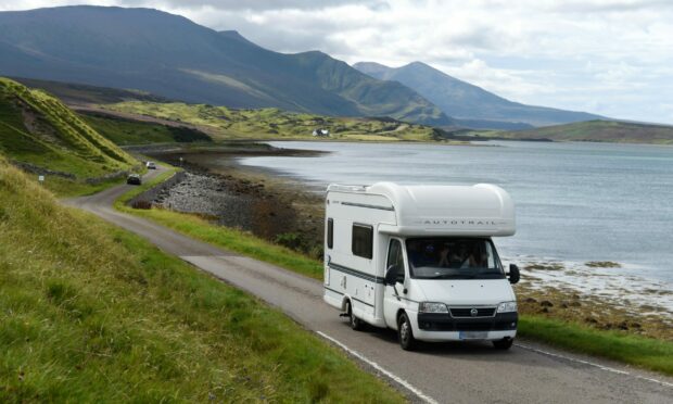
Drivers planning to travel on the North Coast 500 this Easter weekend are being encouraged to be aware of coverage not-spots.

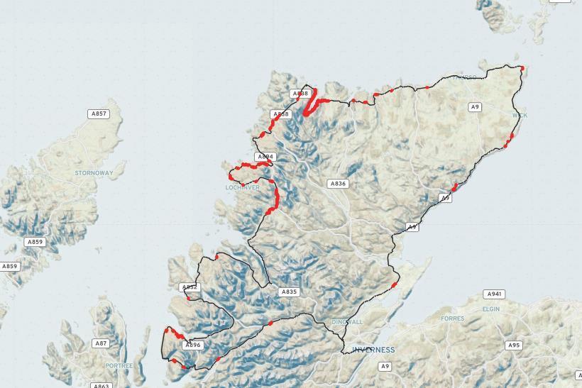
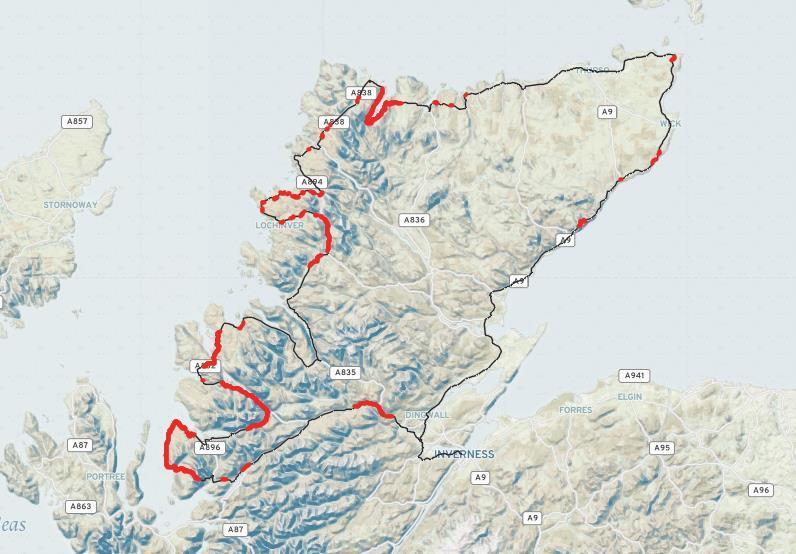
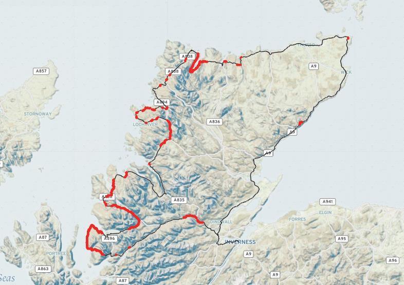
A new interactive map has found that more than 34 miles along Scotland’s most popular route are not covered by 4G.

The map has been made freely available to tourists in the hopes of raising awareness of connectivity issues in the area.

For those wanting to go off-the-grid, this might sound like a dream holiday. Hours of road-tripping through beautiful countryside uninterrupted by tweets, notifications or emails might appear ideal for many wanting to switch off.

However, digital connectivity consultancy FarrPoint says this lack of signal can also be a danger. As such, they are encouraging holiday makers to plan and prepare accordingly to help avoid any nasty surprises.

Which providers offer best 4G coverage on NC500?

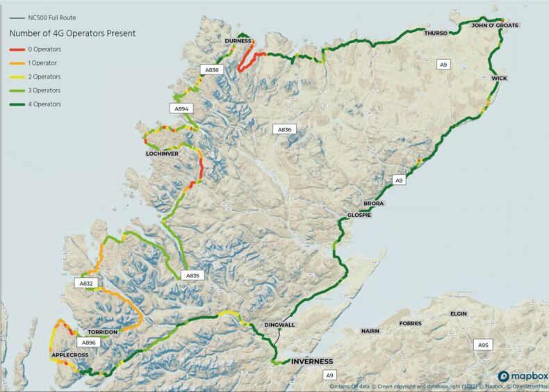
Created by FarrPoint, the new map outlines the level of 4G coverage in each location.

This was done by looking at the coverage offered by four of the UK’s mobile network operators, EE, O2, Three and Vodafone along the 516 mile route.

Along the NC500, FarrPoint identified more than 34 miles without 4G coverage from any provider. Another quarter of the road was only covered by one or two of the mobile providers.

EE offered the best coverage along the popular route. Supplied by FarrPoint.

According to information gathered, EE was found to offer the best coverage with access to its network found across 89% of the road.

This was closely followed by O2 at 77% and Vodafone at 76%.

O2 mobile network provider was found to offer 77% coverage along the route. Supplied by FarrPoint.
Vodafone offered 76% coverage. Supplied by FarrPoint.

Three only provided coverage for 51% of the route leaving more than 252 miles without access to 4G.

Over 252 miles were left without 4G coverage from Three along the route. Supplied by FarrPoint.

Areas of route with no 4G coverage

Some of the most popular tourists destinations that were classed as digital not-spots included Inverewe Garden and Estate, the Applecross Peninsula, Beinn Eighe National Nature Reserve and the stunning Clachtoll Beach.

The road along the shoreline of Britain’s deepest sea loch, Loch Eriboll, was the worst area for mobile coverage. This left 18 miles of continuous road with no 4G access.

Drivers can quickly run into issues while driving along winding country roads and with no connectivity this can quickly cause bigger problems.

Andrew Muir, CEO at FarrPoint, said: “With stunning scenery and views, the North Coast 500 provides the setting for one of the world’s best road journeys right here in Scotland.

“But without adequate preparation, the trip could turn into difficulty in parts given the remote nature of the surrounding area and the limited connectivity across the route.

“With more than 34 miles of the NC500 having no 4G coverage from any operator, and hundreds of miles of road only being covered by certain operators, undoubtedly people will experience connectivity issues during their journey.

The new interactive map shows different areas without 4G coverage along the popular NC500 route. Supplied by FarrPoint.

“This may appeal to some travellers who are looking to have a break from their digital devices, but it could equally cause issues if drivers get lost or run into trouble.”

Visitors using the route are encouraged to look at coverage levels in advance and plan accordingly. To view the interactive map, visit FarrPoint’s website.