Calendar An icon of a desk calendar. Cancel An icon of a circle with a diagonal line across. Caret An icon of a block arrow pointing to the right. Email An icon of a paper envelope. Facebook An icon of the Facebook "f" mark. Google An icon of the Google "G" mark. Linked In An icon of the Linked In "in" mark. Logout An icon representing logout. Profile An icon that resembles human head and shoulders. Telephone An icon of a traditional telephone receiver. Tick An icon of a tick mark. Is Public An icon of a human eye and eyelashes. Is Not Public An icon of a human eye and eyelashes with a diagonal line through it. Pause Icon A two-lined pause icon for stopping interactions. Quote Mark A opening quote mark. Quote Mark A closing quote mark. Arrow An icon of an arrow. Folder An icon of a paper folder. Breaking An icon of an exclamation mark on a circular background. Camera An icon of a digital camera. Caret An icon of a caret arrow. Clock An icon of a clock face. Close An icon of the an X shape. Close Icon An icon used to represent where to interact to collapse or dismiss a component Comment An icon of a speech bubble. Comments An icon of a speech bubble, denoting user comments. Comments An icon of a speech bubble, denoting user comments. Ellipsis An icon of 3 horizontal dots. Envelope An icon of a paper envelope. Facebook An icon of a facebook f logo. Camera An icon of a digital camera. Home An icon of a house. Instagram An icon of the Instagram logo. LinkedIn An icon of the LinkedIn logo. Magnifying Glass An icon of a magnifying glass. Search Icon A magnifying glass icon that is used to represent the function of searching. Menu An icon of 3 horizontal lines. Hamburger Menu Icon An icon used to represent a collapsed menu. Next An icon of an arrow pointing to the right. Notice An explanation mark centred inside a circle. Previous An icon of an arrow pointing to the left. Rating An icon of a star. Tag An icon of a tag. Twitter An icon of the Twitter logo. Video Camera An icon of a video camera shape. Speech Bubble Icon A icon displaying a speech bubble WhatsApp An icon of the WhatsApp logo. Information An icon of an information logo. Plus A mathematical 'plus' symbol. Duration An icon indicating Time. Success Tick An icon of a green tick. Success Tick Timeout An icon of a greyed out success tick. Loading Spinner An icon of a loading spinner. Facebook Messenger An icon of the facebook messenger app logo. Facebook An icon of a facebook f logo. Facebook Messenger An icon of the Twitter app logo. LinkedIn An icon of the LinkedIn logo. WhatsApp Messenger An icon of the Whatsapp messenger app logo. Email An icon of an mail envelope. Copy link A decentered black square over a white square.

More rain on the way for the north and north-east

The north was hit the hardest with motorists at Slochd on the A9 delayed yesterday morning in unfavorable driving conditions. Picture by Sandy McCook

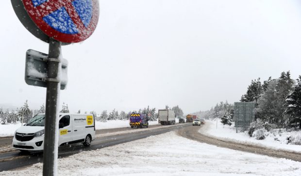
The weather across Aberdeen, the north-east, Moray and the Highlands and Islands is set to improve, but rain will visit every region in the coming days.

Met Office meteorologist Alex Burkill said: “Thursday is going to bring with it persistent rain across the whole of the northern region, covering as far north as Orkney and the northern isles but not reaching Shetland.

“Underfoot for the early parts it may be icy, so we would urge people to take care when out and about.

“Some sleet and snow are to be expected on the highest peaks of above 600m, but nothing like the levels we experienced on Wednesday. We will experience mostly rain and the air will be just a little bit warmer, with winds easing up and becoming lighter.

“The Western Isles and far north will still experience high winds of up to 30-40mph, adding to the cold feel in the air, as it shapes up to be a cold one with highs of around eight degrees at best.

Weather hampers north as schools are closed, motorists delayed and trees felled across the region

“Overnight and into Friday, we are expecting to see further rain throughout the night and we could see temperatures as low as zero overnight, so again a there will be a touch of frost and maybe some icy patches.

“On Friday itself, some rain is anticipated but we anticipate this to break up across the afternoon. It will be drier throughout the day with winds easing up by mid-afternoon, and we could see highs of 11 or 12 degrees.

“The weekend is going to get off to a wet start with rain pushing in from the east and the day becoming a bit blustery. Temperatures will be a little cooler than Friday where we are expecting highs of around seven or eight degrees for most of the north, with the Western Isles experiencing the best of the day, with highs of around 11 or 12 degrees and mostly dry spells.

“Sunday is looking largely dry with a few showers pushing in from the east, hitting Orkney and Shetland first. The showers will be fairly scattered, with areas often dry with some bright sunny spells.”