Calendar An icon of a desk calendar. Cancel An icon of a circle with a diagonal line across. Caret An icon of a block arrow pointing to the right. Email An icon of a paper envelope. Facebook An icon of the Facebook "f" mark. Google An icon of the Google "G" mark. Linked In An icon of the Linked In "in" mark. Logout An icon representing logout. Profile An icon that resembles human head and shoulders. Telephone An icon of a traditional telephone receiver. Tick An icon of a tick mark. Is Public An icon of a human eye and eyelashes. Is Not Public An icon of a human eye and eyelashes with a diagonal line through it. Pause Icon A two-lined pause icon for stopping interactions. Quote Mark A opening quote mark. Quote Mark A closing quote mark. Arrow An icon of an arrow. Folder An icon of a paper folder. Breaking An icon of an exclamation mark on a circular background. Camera An icon of a digital camera. Caret An icon of a caret arrow. Clock An icon of a clock face. Close An icon of the an X shape. Close Icon An icon used to represent where to interact to collapse or dismiss a component Comment An icon of a speech bubble. Comments An icon of a speech bubble, denoting user comments. Comments An icon of a speech bubble, denoting user comments. Ellipsis An icon of 3 horizontal dots. Envelope An icon of a paper envelope. Facebook An icon of a facebook f logo. Camera An icon of a digital camera. Home An icon of a house. Instagram An icon of the Instagram logo. LinkedIn An icon of the LinkedIn logo. Magnifying Glass An icon of a magnifying glass. Search Icon A magnifying glass icon that is used to represent the function of searching. Menu An icon of 3 horizontal lines. Hamburger Menu Icon An icon used to represent a collapsed menu. Next An icon of an arrow pointing to the right. Notice An explanation mark centred inside a circle. Previous An icon of an arrow pointing to the left. Rating An icon of a star. Tag An icon of a tag. Twitter An icon of the Twitter logo. Video Camera An icon of a video camera shape. Speech Bubble Icon A icon displaying a speech bubble WhatsApp An icon of the WhatsApp logo. Information An icon of an information logo. Plus A mathematical 'plus' symbol. Duration An icon indicating Time. Success Tick An icon of a green tick. Success Tick Timeout An icon of a greyed out success tick. Loading Spinner An icon of a loading spinner. Facebook Messenger An icon of the facebook messenger app logo. Facebook An icon of a facebook f logo. Facebook Messenger An icon of the Twitter app logo. LinkedIn An icon of the LinkedIn logo. WhatsApp Messenger An icon of the Whatsapp messenger app logo. Email An icon of an mail envelope. Copy link A decentered black square over a white square.

FROM THE AIR: Interactive tool shows how much Inverness and Fort William have changed in 75 years

Post Thumbnail

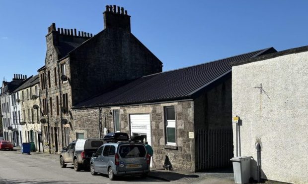
A fascinating interactive map of parts of Inverness and Fort Williams illustrate how the areas have changed since the Second World War.

Aerial photography of the two largest settlements in the Highlands from the 1940s and the present day can be compared using a digital spyglass viewer.

Using the tool, people can see an instant comparison of modern day pictures from the air of the place where the live with black and white images of how it looked up to 75 years ago.

Inverness was dubbed the fastest growing city in western Europe in the noughties and unsurprisingly, its landscape has changed a lot since the 1940s.

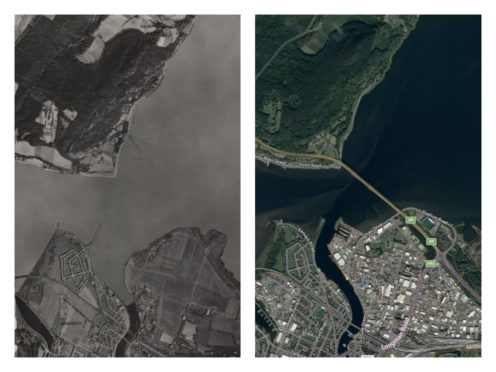
One of the first things that stands out from our first overview showing the Black Isle and the north part of the city is the creation of the Kessock Bridge.

It opened in 1982 and created a whole raft of changes on both sides of the Beauly Firth. Check out how the modern-day Longman and Harbour Road areas looked back then, there was not much to them.

There was also a lot of expansion around Merkinch and Scorguie. Perhaps most interestingly of all, is the Moray Firth coast where Caley Thistle’s stadium now sits.

Check out how the coastline changes, thanks to the reclamation of land using rocks, sand and soil close to the old Longman dump.

The south side of Inverness is continually expanding and areas like Inshes, Slackbuie and Milton of Leys have become some of the most sought-after locations in the city.

Culduthel Road is a thoroughfare cutting almost through the centre of modern Inverness but back in the 1940s it acted more like a town boundary.

Across central Inverness, there is a more familiar look as the main parts of the modern city centre have retained their structure.

In Fort William, the growth of areas like Caol, Corpach and Banavie are seen clearly on the comparison map.

The Lochaber smelter, which dates back to the 1920s and is expected to be part of an alloy wheels factory project opening next year, is visible in both aerial shots on the east part of the town.

The National Library of Scotland’s maps room shared a link to the Ordnance Survey air photo mosaics with its Spyglass viewer on Twitter to celebrate World Photo Day.

The mosaics provide information on the landscape of post-war Scotland, including detail of urban topography and land-use.

They complement paper mapping and represent the first widespread use of aerial survey methods by Ordnance Survey.

Due to post-war budget constraints, the 1940s photographs were taken from Spitfires and Mosquitos rather than slower aircraft more suited to aerial survey, and the planes were modified to take two cameras under each wing.

You can check out similar maps for Aberdeen here.

And for Dundee and Fife, click here.