Calendar An icon of a desk calendar. Cancel An icon of a circle with a diagonal line across. Caret An icon of a block arrow pointing to the right. Email An icon of a paper envelope. Facebook An icon of the Facebook "f" mark. Google An icon of the Google "G" mark. Linked In An icon of the Linked In "in" mark. Logout An icon representing logout. Profile An icon that resembles human head and shoulders. Telephone An icon of a traditional telephone receiver. Tick An icon of a tick mark. Is Public An icon of a human eye and eyelashes. Is Not Public An icon of a human eye and eyelashes with a diagonal line through it. Pause Icon A two-lined pause icon for stopping interactions. Quote Mark A opening quote mark. Quote Mark A closing quote mark. Arrow An icon of an arrow. Folder An icon of a paper folder. Breaking An icon of an exclamation mark on a circular background. Camera An icon of a digital camera. Caret An icon of a caret arrow. Clock An icon of a clock face. Close An icon of the an X shape. Close Icon An icon used to represent where to interact to collapse or dismiss a component Comment An icon of a speech bubble. Comments An icon of a speech bubble, denoting user comments. Comments An icon of a speech bubble, denoting user comments. Ellipsis An icon of 3 horizontal dots. Envelope An icon of a paper envelope. Facebook An icon of a facebook f logo. Camera An icon of a digital camera. Home An icon of a house. Instagram An icon of the Instagram logo. LinkedIn An icon of the LinkedIn logo. Magnifying Glass An icon of a magnifying glass. Search Icon A magnifying glass icon that is used to represent the function of searching. Menu An icon of 3 horizontal lines. Hamburger Menu Icon An icon used to represent a collapsed menu. Next An icon of an arrow pointing to the right. Notice An explanation mark centred inside a circle. Previous An icon of an arrow pointing to the left. Rating An icon of a star. Tag An icon of a tag. Twitter An icon of the Twitter logo. Video Camera An icon of a video camera shape. Speech Bubble Icon A icon displaying a speech bubble WhatsApp An icon of the WhatsApp logo. Information An icon of an information logo. Plus A mathematical 'plus' symbol. Duration An icon indicating Time. Success Tick An icon of a green tick. Success Tick Timeout An icon of a greyed out success tick. Loading Spinner An icon of a loading spinner. Facebook Messenger An icon of the facebook messenger app logo. Facebook An icon of a facebook f logo. Facebook Messenger An icon of the Twitter app logo. LinkedIn An icon of the LinkedIn logo. WhatsApp Messenger An icon of the Whatsapp messenger app logo. Email An icon of an mail envelope. Copy link A decentered black square over a white square.

North of Scotland braced for more disruption as Met Office warns of flooding and gusts of up to 75mph

Post Thumbnail

Parts of the Highlands are being warned of more travel disruption as heavy rain is forecasted to batter the region.

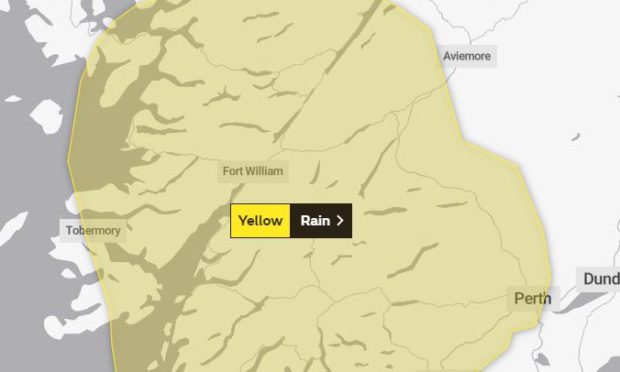
The Met Office has issued a yellow alert for heavy rain for a large area of the north from Aviemore across to Fort William and further up the west coast.

It covers from 6am to 9pm on Friday.

The warning says heavy rain may lead to some travel disruption and local flooding.

“Persistent and sometimes heavy rain is expected across the western and central Highlands along with southern Scotland on Friday”, the full warning reads.

“Accumulations of 30 to 40 mm are likely on high ground with peaks of 60 mm across the southern and central Highlands. Drier conditions will extend from the northwest through the evening.”

A separate alert has been issued for Saturday for the whole of the north of Scotland warning of “strong gusty winds”.

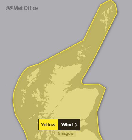
The Met Office said: “Strong, gusty winds are expected across Scotland, Northern Ireland and parts of northern England during Saturday. The strongest winds will likely occur in the vicinity of heavy, squally showers.

“Whilst not all areas will see the strongest winds, gusts of 55-65 mph are expected in places. Exposed parts of northern and western Scotland may see gusts of 65-75 mph.

Showers will fall as a mixture of rain, hail and sleet with snow accumulations expected to be restricted to higher ground (above 200 to 300 m). Winds will gradually moderate during Saturday evening.”