Calendar An icon of a desk calendar. Cancel An icon of a circle with a diagonal line across. Caret An icon of a block arrow pointing to the right. Email An icon of a paper envelope. Facebook An icon of the Facebook "f" mark. Google An icon of the Google "G" mark. Linked In An icon of the Linked In "in" mark. Logout An icon representing logout. Profile An icon that resembles human head and shoulders. Telephone An icon of a traditional telephone receiver. Tick An icon of a tick mark. Is Public An icon of a human eye and eyelashes. Is Not Public An icon of a human eye and eyelashes with a diagonal line through it. Pause Icon A two-lined pause icon for stopping interactions. Quote Mark A opening quote mark. Quote Mark A closing quote mark. Arrow An icon of an arrow. Folder An icon of a paper folder. Breaking An icon of an exclamation mark on a circular background. Camera An icon of a digital camera. Caret An icon of a caret arrow. Clock An icon of a clock face. Close An icon of the an X shape. Close Icon An icon used to represent where to interact to collapse or dismiss a component Comment An icon of a speech bubble. Comments An icon of a speech bubble, denoting user comments. Comments An icon of a speech bubble, denoting user comments. Ellipsis An icon of 3 horizontal dots. Envelope An icon of a paper envelope. Facebook An icon of a facebook f logo. Camera An icon of a digital camera. Home An icon of a house. Instagram An icon of the Instagram logo. LinkedIn An icon of the LinkedIn logo. Magnifying Glass An icon of a magnifying glass. Search Icon A magnifying glass icon that is used to represent the function of searching. Menu An icon of 3 horizontal lines. Hamburger Menu Icon An icon used to represent a collapsed menu. Next An icon of an arrow pointing to the right. Notice An explanation mark centred inside a circle. Previous An icon of an arrow pointing to the left. Rating An icon of a star. Tag An icon of a tag. Twitter An icon of the Twitter logo. Video Camera An icon of a video camera shape. Speech Bubble Icon A icon displaying a speech bubble WhatsApp An icon of the WhatsApp logo. Information An icon of an information logo. Plus A mathematical 'plus' symbol. Duration An icon indicating Time. Success Tick An icon of a green tick. Success Tick Timeout An icon of a greyed out success tick. Loading Spinner An icon of a loading spinner. Facebook Messenger An icon of the facebook messenger app logo. Facebook An icon of a facebook f logo. Facebook Messenger An icon of the Twitter app logo. LinkedIn An icon of the LinkedIn logo. WhatsApp Messenger An icon of the Whatsapp messenger app logo. Email An icon of an mail envelope. Copy link A decentered black square over a white square.

Study finds lost Viking waterway through Orkney mainland

Dr Martin Bates, one of the researchers involved in the Viking waterway discovery.

An investigation has revealed a long lost Viking waterway running through mainland Orkney which once provided access to the stronghold of the islands’ ancient rulers.

It is believed the ancient ‘highway’ ran more than 10 miles, connecting a series of canals from the North Atlantic to Scapa Flow.

That waterway provided an essential trade route to allow the Vikings to haul boats and heavy goods, such as grain, and collect rents and taxes from wealthy estates.

The findings are the result of a collaboration between the universities of the Highlands and Islands, St Andrews and Wales and will be published in the Journal of Wetland Archaeology.

Orkney was a key area of power for Norse earls from the ninth to 12th centuries.

Old Norse place names connected to the sea and boats in the middle of Orkney’s mainland provided clues to the waterways that have disappeared due to later drainage projects and changes in climate and sea level.

They included ‘Greenay’, meaning shallow waters, and ‘Knarston’, derived from the words for a transport vessel and a farm or homestead where these vessels were moored.

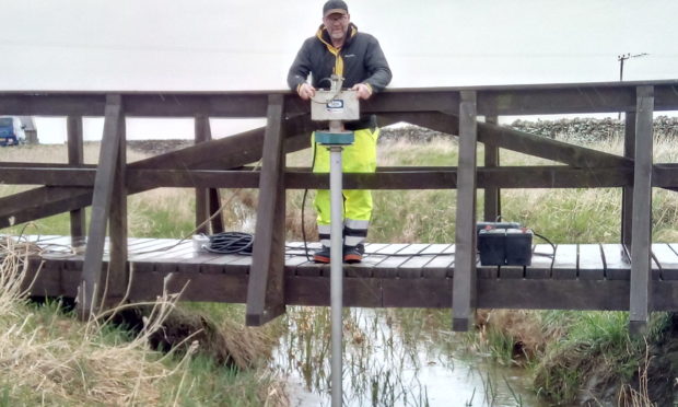
Researchers using remote sensing geophysical mapping and sediment samples were able to rediscover a series of now infilled channels from the Loch of Harray to the lochs of Sabiston and Boardhouse towards the earls’ seat of power in Birsay.

They say the results could help historians and archaeologists find more evidence of water transport in the Viking Age and Late Norse period in the isles.

Similar navigable waterways are known elsewhere in Scotland, including at Rubh an Dunain in Skye.

Dr Richard Bates of the school of earth and environmental sciences at St Andrews University said: “It is quite fascinating to see how the scientific investigation can be verified by the toponymic study.

“I would not have believed that both parts of the evidence would have survived nearly a millennia of change.”

Dr Alexandra Sanmark, of the Institute for Northern Studies at the University of the Highlands and Islands, added: “I am delighted with the outcome, as multiple pieces of written and landscape evidence suggested the existence of the waterway.”