A storm which has been officially named Gertrude by the Met Office has been forecast to bring heavy rain, high winds, snow and ice to Scotland on Friday.
The Met Office has issued amber “be prepared” and yellow “be aware” warnings for Scotland and large parts of the rest of the UK.
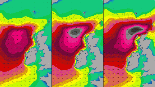
The amber warning for high winds is in place from 3am to 10am on Friday.
The Met Office has also issued a yellow warning of rain falling to 40mm-60mm over western Scotland and north of central Scotland on Friday.
A separate yellow warning of snow and freezing temperatures covers from 21:00 on Friday to 15:00 on Saturday.
The Met Office said: “Showers, frequent and heavy at times, will turn increasingly to snow through Friday evening.
“The heaviest snow showers are most likely to the north of the central belt of Scotland. Here, away from the immediate coast, around five to 10cm of snow could accumulate through Friday night and Saturday morning.
“Elsewhere, snow accumulations will be more localised, around 1cm to 3 cm is possible and primarily above 200m. Road surface temperatures are expected to fall below freezing overnight into Saturday morning, leading to a risk of icy patches forming.”
Charts produced by surfers’ website Magicseaweed.com forecast swells of up to 48ft (14m) out to sea.
The amber warning includes a forecast of winds gusting to 60mph or 70mph across wide areas and to 80mph on exposed coasts. The wind speeds have been forecast to reduce during Friday afternoon.
Rain is expected to spread from the west during Thursday, gradually turning heavier and more persistent.
The heaviest rainfall will be over high ground, initially across western Scotland, then developing across northwest England and Wales during Thursday afternoon and evening. Drier conditions, albeit with some showers, are expected to reach Scotland late Friday morning, with the rain expected to clear northwest England and north Wales by midday.
Be aware of the potential for further localised flooding and disruption to travel.
Another area of low pressure is expected to move quickly east across the Atlantic, bringing another spell of heavy rain to western parts of the UK.
Across western Scotland, north of the Central Belt, around 40-60 mm of rain is expected to fall quite widely, with up to 100 mm possible over high ground.
Across the rest of Scotland, rainfall amounts are likely to be lower, with 20-40 mm falling widely and up to 60 mm possible over high ground.
Today:
Mainly cloudy with showers, these wintry at first. Showers merging into a longer spell of rain in during the afternoon. Best of any sunny intervals around the Moray Firth area. A breezy day with fresh or strong southwesterly winds. Maximum Temperature 7°C.
Tonight:
Clear spells at first in east. Otherwise, cloudy with rain becoming persistent and heavy. Southwesterly winds strengthening to severe gale force later, becoming storm force over Hebrides and west coast. Minimum Temperature 3°C.
Friday:
Heavy rain will be soon followed by bright spells and squally showers. Very strong west or southwesterly winds with severe gales or storm force winds. Snow showers developing overnight. Maximum Temperature 7°C.
Outlook for Saturday to Monday:
Bitterly cold Saturday with sleet or snow showers and gales. Becoming mainly dry Sunday with lighter winds but rain arriving and turning milder later. Very unsettled again on Monday.