Calendar An icon of a desk calendar. Cancel An icon of a circle with a diagonal line across. Caret An icon of a block arrow pointing to the right. Email An icon of a paper envelope. Facebook An icon of the Facebook "f" mark. Google An icon of the Google "G" mark. Linked In An icon of the Linked In "in" mark. Logout An icon representing logout. Profile An icon that resembles human head and shoulders. Telephone An icon of a traditional telephone receiver. Tick An icon of a tick mark. Is Public An icon of a human eye and eyelashes. Is Not Public An icon of a human eye and eyelashes with a diagonal line through it. Pause Icon A two-lined pause icon for stopping interactions. Quote Mark A opening quote mark. Quote Mark A closing quote mark. Arrow An icon of an arrow. Folder An icon of a paper folder. Breaking An icon of an exclamation mark on a circular background. Camera An icon of a digital camera. Caret An icon of a caret arrow. Clock An icon of a clock face. Close An icon of the an X shape. Close Icon An icon used to represent where to interact to collapse or dismiss a component Comment An icon of a speech bubble. Comments An icon of a speech bubble, denoting user comments. Comments An icon of a speech bubble, denoting user comments. Ellipsis An icon of 3 horizontal dots. Envelope An icon of a paper envelope. Facebook An icon of a facebook f logo. Camera An icon of a digital camera. Home An icon of a house. Instagram An icon of the Instagram logo. LinkedIn An icon of the LinkedIn logo. Magnifying Glass An icon of a magnifying glass. Search Icon A magnifying glass icon that is used to represent the function of searching. Menu An icon of 3 horizontal lines. Hamburger Menu Icon An icon used to represent a collapsed menu. Next An icon of an arrow pointing to the right. Notice An explanation mark centred inside a circle. Previous An icon of an arrow pointing to the left. Rating An icon of a star. Tag An icon of a tag. Twitter An icon of the Twitter logo. Video Camera An icon of a video camera shape. Speech Bubble Icon A icon displaying a speech bubble WhatsApp An icon of the WhatsApp logo. Information An icon of an information logo. Plus A mathematical 'plus' symbol. Duration An icon indicating Time. Success Tick An icon of a green tick. Success Tick Timeout An icon of a greyed out success tick. Loading Spinner An icon of a loading spinner. Facebook Messenger An icon of the facebook messenger app logo. Facebook An icon of a facebook f logo. Facebook Messenger An icon of the Twitter app logo. LinkedIn An icon of the LinkedIn logo. WhatsApp Messenger An icon of the Whatsapp messenger app logo. Email An icon of an mail envelope. Copy link A decentered black square over a white square.

Travel maps provide safer routes for tourists and residents in Inverness

Post Thumbnail

Active travel maps to provide information for tourists and residents to plan safer routes around Inverness have been updated.

The popular map for the Highland capital is now available online and has been reprinted.

The map, produced by Hitrans, the regional transport partnership for the Highlands and Islands, highlights recommended cycle routes, bike shops, repair shops, bike hire, bike parking and transport hubs such as the railway station and bus station.

The updated map includes new cycling infrastructure linking the canal paths via the new multi-million pound West Link bypass to the Southern Distributor road, and links between Beechwood, Inverness Campus, the Retail Park and Culloden.

Councillor Allan Henderson, chairman of Hitrans said: “With the Highland Council declaring a climate and ecological emergency, there is much that each of us can do individually to help the Highlands reach the target of being carbon neutral by 2025.

“Transport accounts for 27% of Scotland’s greenhouse gas emissions so choosing to walk or cycle instead of taking the car for journeys under five miles has a positive impact on carbon emissions, air quality and traffic movements, making our streets more liveable.

“Driving less could mean a mixture of car sharing, walking, cycling or using public transport for all or part of a journey.”

An active travel map is also being developed for Fort William and is due to be printed later in the year.

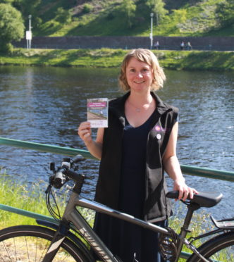
Leading the production of active travel maps is Vikki Trelfer, an officer for Hitrans.

She said: “Our aim is to provide a practical network of high quality routes suitable for pedestrians and cyclists that provide convenient and safe access throughout the city, to and from the railway station, bus stops, major employment areas, local shopping areas, leisure/recreation centres, and hospitals.

“That way it becomes easy for people to make different choices about how they get around.”

The free map is available in bike shops and workplaces around town, and a pdf version can be downloaded from the Hitrans website: www.hitrans.org.uk/hitravel.