Calendar An icon of a desk calendar. Cancel An icon of a circle with a diagonal line across. Caret An icon of a block arrow pointing to the right. Email An icon of a paper envelope. Facebook An icon of the Facebook "f" mark. Google An icon of the Google "G" mark. Linked In An icon of the Linked In "in" mark. Logout An icon representing logout. Profile An icon that resembles human head and shoulders. Telephone An icon of a traditional telephone receiver. Tick An icon of a tick mark. Is Public An icon of a human eye and eyelashes. Is Not Public An icon of a human eye and eyelashes with a diagonal line through it. Pause Icon A two-lined pause icon for stopping interactions. Quote Mark A opening quote mark. Quote Mark A closing quote mark. Arrow An icon of an arrow. Folder An icon of a paper folder. Breaking An icon of an exclamation mark on a circular background. Camera An icon of a digital camera. Caret An icon of a caret arrow. Clock An icon of a clock face. Close An icon of the an X shape. Close Icon An icon used to represent where to interact to collapse or dismiss a component Comment An icon of a speech bubble. Comments An icon of a speech bubble, denoting user comments. Comments An icon of a speech bubble, denoting user comments. Ellipsis An icon of 3 horizontal dots. Envelope An icon of a paper envelope. Facebook An icon of a facebook f logo. Camera An icon of a digital camera. Home An icon of a house. Instagram An icon of the Instagram logo. LinkedIn An icon of the LinkedIn logo. Magnifying Glass An icon of a magnifying glass. Search Icon A magnifying glass icon that is used to represent the function of searching. Menu An icon of 3 horizontal lines. Hamburger Menu Icon An icon used to represent a collapsed menu. Next An icon of an arrow pointing to the right. Notice An explanation mark centred inside a circle. Previous An icon of an arrow pointing to the left. Rating An icon of a star. Tag An icon of a tag. Twitter An icon of the Twitter logo. Video Camera An icon of a video camera shape. Speech Bubble Icon A icon displaying a speech bubble WhatsApp An icon of the WhatsApp logo. Information An icon of an information logo. Plus A mathematical 'plus' symbol. Duration An icon indicating Time. Success Tick An icon of a green tick. Success Tick Timeout An icon of a greyed out success tick. Loading Spinner An icon of a loading spinner. Facebook Messenger An icon of the facebook messenger app logo. Facebook An icon of a facebook f logo. Facebook Messenger An icon of the Twitter app logo. LinkedIn An icon of the LinkedIn logo. WhatsApp Messenger An icon of the Whatsapp messenger app logo. Email An icon of an mail envelope. Copy link A decentered black square over a white square.

Orkney has the riskiest road in Scotland

Post Thumbnail

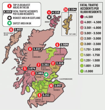
The deadliest road in Scotland can be found in Orkney, figures have revealed.

A map of the most dangerous roads in Britain has been created using using fatality data gathered by the Department of Transport and the Police Service of Northern Ireland over a five-year period.

The rate of accidents per head of population has been found to be highest on the A965 Kirkwall to Stromness, making it the fourth highest in the whole of the UK.

The odds are partly affected by Orkney having a smaller population. Between 2012 and 2016 there were 4.110 fatal traffic accidents per 10,000 residents.

Argyll and Bute  with 3.674; Aberdeenshire, 3.509; and Perth and Kinross, 3.251; had the next highest rates in Scotland.

The figures came from the A83 Tarbet to Campbeltown road in Argyll, the A90 Perth to Fraserburgh in Aberdeenshire and the A9 in Perth and Kinross.

Highland was fourth in Scotland, with 3.237 on the A9.

Scotland’s smallest county, Clackmannanshire, was named the safest area in the UK and recorded no fatalities during the period.

Margaret Dekker, researcher for the Scottish Campaign Against Irresponsible Driving, said: “There are a lot of issues here. A graded licence scheme for younger drivers has been talked about for years, I don’t know what’s holding that up. Young drivers would not be allowed to carry passengers in the evening.

“This figure is worrying for Orkney and the other areas. It is just so sad.

“We need to do more to find out what’s behind these incidents. We don’t call them accidents we call them road collisions or crashes because 95% of them are driver-based.”

June Ross of Stone Gables, Alford in Aberdeenshire, lost her son Ian Buchanan, 22, in a crash in 2010. She launched the Don’t You Forget About Me support group to help other grieving families and friends.

She said: “I’m quite surprised but I’m not surprised, it’s a mixed feeling. Aberdeenshire is dreadful.

“Some of the roads are just incredibly frustrating for everybody, with farm vehicles at rush hour. They don’t seem to be improving at any rapid pace.

“They are very dangerous roads, people who are travelling on them often travel fast because they know the road.

“There are a lot of places where the signage could be a lot better. The fatalities are probably still the young folk and the speeding.

“Things are not changing as quickly as they need to.”

Telematics technology business Teletrac Navman has created the map. Peter Millichap, UK marketing director at Teletrac Navman, said: “When operating a fleet, driver safety is extremely high on the agenda. As such, knowing which stretches of road are the most dangerous can help operators reduce the risk of accidents by adjusting their routes or schedules accordingly.”