Calendar An icon of a desk calendar. Cancel An icon of a circle with a diagonal line across. Caret An icon of a block arrow pointing to the right. Email An icon of a paper envelope. Facebook An icon of the Facebook "f" mark. Google An icon of the Google "G" mark. Linked In An icon of the Linked In "in" mark. Logout An icon representing logout. Profile An icon that resembles human head and shoulders. Telephone An icon of a traditional telephone receiver. Tick An icon of a tick mark. Is Public An icon of a human eye and eyelashes. Is Not Public An icon of a human eye and eyelashes with a diagonal line through it. Pause Icon A two-lined pause icon for stopping interactions. Quote Mark A opening quote mark. Quote Mark A closing quote mark. Arrow An icon of an arrow. Folder An icon of a paper folder. Breaking An icon of an exclamation mark on a circular background. Camera An icon of a digital camera. Caret An icon of a caret arrow. Clock An icon of a clock face. Close An icon of the an X shape. Close Icon An icon used to represent where to interact to collapse or dismiss a component Comment An icon of a speech bubble. Comments An icon of a speech bubble, denoting user comments. Comments An icon of a speech bubble, denoting user comments. Ellipsis An icon of 3 horizontal dots. Envelope An icon of a paper envelope. Facebook An icon of a facebook f logo. Camera An icon of a digital camera. Home An icon of a house. Instagram An icon of the Instagram logo. LinkedIn An icon of the LinkedIn logo. Magnifying Glass An icon of a magnifying glass. Search Icon A magnifying glass icon that is used to represent the function of searching. Menu An icon of 3 horizontal lines. Hamburger Menu Icon An icon used to represent a collapsed menu. Next An icon of an arrow pointing to the right. Notice An explanation mark centred inside a circle. Previous An icon of an arrow pointing to the left. Rating An icon of a star. Tag An icon of a tag. Twitter An icon of the Twitter logo. Video Camera An icon of a video camera shape. Speech Bubble Icon A icon displaying a speech bubble WhatsApp An icon of the WhatsApp logo. Information An icon of an information logo. Plus A mathematical 'plus' symbol. Duration An icon indicating Time. Success Tick An icon of a green tick. Success Tick Timeout An icon of a greyed out success tick. Loading Spinner An icon of a loading spinner. Facebook Messenger An icon of the facebook messenger app logo. Facebook An icon of a facebook f logo. Facebook Messenger An icon of the Twitter app logo. LinkedIn An icon of the LinkedIn logo. WhatsApp Messenger An icon of the Whatsapp messenger app logo. Email An icon of an mail envelope. Copy link A decentered black square over a white square.

Weather warning: More thunderstorms and downpours forecast for Moray

The road was swept away at Tomintoul, Moray last week during the storms

Moray will be battered by gale force winds tomorrow – just days after being soaked by torrential rain storms.

Long-suffering residents – some of who were evacuated from their homes last week – and have been mopping up since then, have been warned they may have to contend with possible structural damage.

And according to forecasters thunderstorms and downpours will again hit the area later in the week.

The Met Office issued a yellow, be aware, severe weather warning today as strong winds are forecast to develop throughout the day, especially in coastal areas and over high ground inland.

And, as schools prepare to re-open for the new term, when the predicted 50mph gales abate, thunderstorms and downpours, as well as very cold conditions, will take over.

Forecasters also say that northerly polar air would chill most of the country from today for a week, with daily highs of just 11-13C in the north.

Scotland will be colder than Moscow, where it will hit 22C today, and 24C or higher each day from tomorrow.

A spokesman for the Met Office said: “A deep low in the North Sea will slowly move away eastwards on Monday. Gusts as strong as 50mph are expected around exposed coasts, and waves will be large.

“While such wind gusts would not be unusual in the autumn and winter, they are likely to pose greater risks in what is still the summer holiday period for some, especially those engaged in outdoor activities such as sailing or hill walking.

“Some disruption to transport is also possible, for example delays to ferries, bridge restrictions and perhaps damage to trees.”

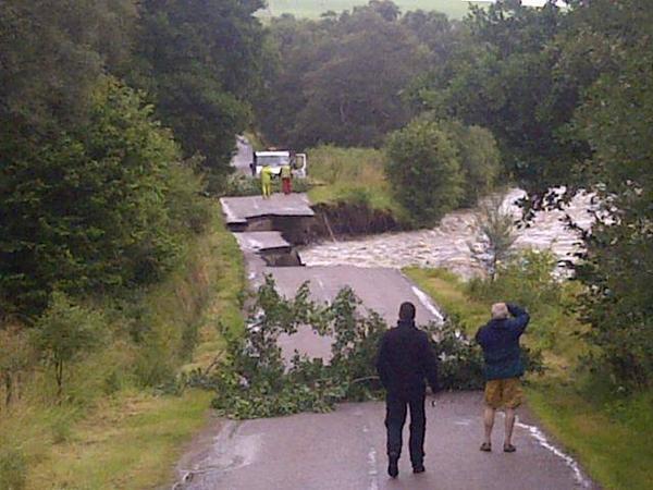
Today, and the remainder of the week, will be another trying period for the people of Moray, who are still counting the cost of Hurricane Bertha’s visit to the area.

Families had to flee their homes as water levels rose incessantly, with some being told that it could be months before they are able to move back in.

It is believed even more rain fell in the area than during the devastating floods of 2009 – which caused tens of millions of pounds of damage.

One businessman was left frustrated after his premises were flooded for the eighth time last week, leaving him facing a repair bill of nearly £30,000.

There will be some respite though by the end of the week with the heavy showers becoming less frequent and brighter intervals in between.

Aberdeen Met Office forecaster Stuart Brooks said last night: “Although this week is going to be unusually cold for the time of year, with snow at the top of the Cairngorms, the winds will become less strong by Thursday.

“Towards the end of the week, temperatures will be back to normal, for the time of year, and the wind will also ease off.”