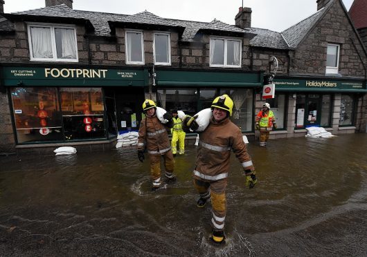
Following another day of flooding misery in Scotland, several north-east roads remain closed or blocked.
Flood warnings, meaning flooding likely, remain in place across Aberdeen and Aberdeenshire.
This morning there are road closures and warnings in place for motorists across the north-east.
- The B993 is closed in both directions between the A947 junction in Whiterashes and the St James’s Place junction in Inverurie, because of flooding.
- The B977 in Hatton of Fintray is closed in both directions between the Fintray junction and the Kintore junction, because of flooding.
- The B979 in Blackburn is closed in both directions between the A96 junction and the B977 junction, because of flooding.
- The B9077 South Deeside Road is closed in both directions between the Leggart Terrace junction in Aberdeen and the B979 junction in Kirkton of Maryculter, because of flooding and subsidence.
- The B976 is closed in both directions between the B974 junction in Strachan and the Feughside Inn junction in Boghead, because of flooding.
- The B974 Cairn O’Mount is closed in both directions between the B976 junction in Strachan and the School Road junction in Fettercairn, because of flooding.
- The A93 in Invercauld is closed in both directions at the Invercauld Bridge junction, because of structural damage to a bridge.
- A diversion is in operation and traffic can only access Braemar by using the A93 Southbound to Perth however the A923 is closed in both directions between the A93 Gas Brae junction in Blairgowrie and the Bogside Road junction in Coupar Angus, because of flooding.
- A93 closed in both directions between the B976 junction in Crathie and the B972 junction in Ballater, because of flooding and subsidence.
- The A937 in Marykirk is closed at the B974 junction, because of flooding.
- The B976 is closed in both directions between the B968 Bridge View Road junction in Aboyne and the B971 Bridge Street junction in Ballater, because of emergency repairs.
- B976 South Deeside Road at Inchmarnoch between Ballater and Dinnet
- B9005 Methlick to Ythanbank
- B9015 Kingston to Garmouth
- B9077 South Deeside Road between Leggart Terrace and the junction with the B979
- Unclassified Kingsfield Road, Kintore to Kinellar
A939 Cock Bridge to the Lecht
CLOSED: A939 Cockbridge-Lecht Ski Centre (snow gate 17) due to snow #ABZTravel
— NE Roads Updates (@PolScotRoadsNE) January 5, 2016
CLOSED: B993 between Inverurie and Blackburn; B9005 Methlick-Ellon, due to flooding #ABZTravel
— NE Roads Updates (@PolScotRoadsNE) January 5, 2016
Kintore and Inverurie have become the latest communities to be affected by the wet weather and flooding that continues to be experienced across the north-east.
Rising water levels saw rest centres opened in Kintore Public Hall and Inverurie Academy on Sunday night, with one property in Kintore being directly affected by flooding.
The rest centres were re-opened this evening (Mon) as rising water levels saw properties hit by flooding in low-lying areas of Port Elphinstone and evacuation of a number of properties.
A further 2,000 sandbags have been made available at the council depot on Harlaw Way, Inverurie, to help residents protect their properties, with more sandbags being placed in key areas of Port Elphinstone and Kintore. The council is grateful to volunteers and residents who filled sandbags on site.
Meanwhile, flood recovery efforts continue in Deeside. Significant efforts were made to boost defences in Ballater on Sunday through the creation of a sandbag barrier along the western edge of the town.
In Braemar, British Telecom has successfully re-established phone lines for households in the town and the Crathie area.
Aboyne was the subject of further flooding today, with both the town’s Bonty Court sheltered housing complex and Allachburn Care Home being evacuated. The Maryculter caravan park was flooded for a second time, although no residents are currently at the site.
Aberdeenshire Council has pledged to provide advice and support to help protect Abergeldie Castle, near Crathie, which is at risk after land next to the River Dee collapsed.
Council engineers have visited the site to establish what action might be taken to help protect the building from being claimed by the river.
Chief Executive of Aberdeenshire Council Jim Savege said: “The ongoing rainfall is causing challenges for a number of our communities, but the support being provided by the emergency services, partner agencies and public volunteers and groups continues to be first class.
“We are conscious of those who have been directly affected by flooding or the impact of damage to roads and bridges and I would like to assure people that we will be looking to carry out repairs as a matter of priority as soon as conditions allow.
“We are also looking to play our part in helping protect the historic Abergeldie Castle through the expertise of our engineers and other staff. We are keen to explore anything we can do to prevent further loss of historic Aberdeenshire landmarks.”
Assessments of routes and structures damaged by Storm Frank have been undertaken and plans for repairs are being developed.
Priorities include repairing the collapsed section of the A93 near Crathie, repairs to the damaged Invercauld road bridge, as well as re-opening routes serving Braemar.
Motorists are urged to respect road closure signs that are in place on a number of routes across the area, both for their own safety and the safety of others. This is particularly important near the collapsed section of road on the A93.