The results of a public vote on two brand new active travel routes for the communities of Kemnay, Kintore and Inverurie have been revealed.
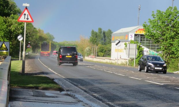
Last year, Aberdeenshire Council asked the public their thoughts on plans for two new cycling and walking routes to link the three areas for people-powered travel.
A feasibility study produced three route options for linking Kemnay with Kintore, and three options for linking Kemnay with Inverurie.
The public were asked to vote for their preferred option from each set of three.
Councillors will next week consider the public’s thoughts on the early indicative plans before deciding which proposals to move forward on.
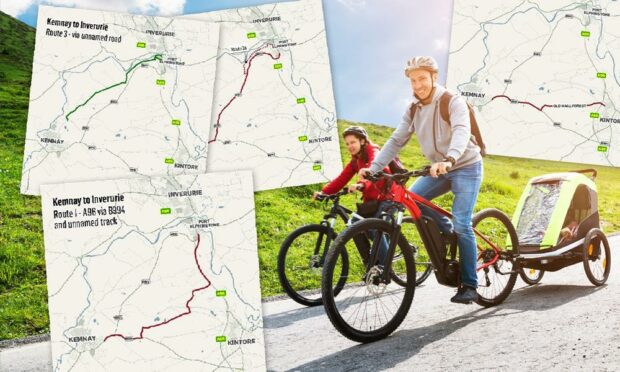
Here are the six active travel route plans the public voted on, and which plans came out top
In total, 877 people took part in the consultation.
Respondents highlighted a number of factors in their answers such as safety, distances from main roads, proximity to homes and even the Aberdeenshire scenery they would take cyclists and pedestrians through.
The three Kemnay to Kintore active travel routes proposals
Kemnay to Kintore route option 1: 23.1% of the vote
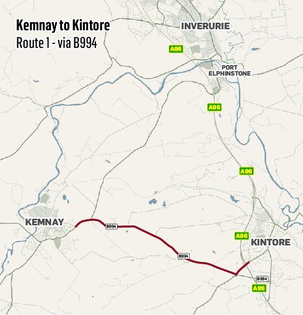
Of the three routes between Kemnay and Kintore put forward, this one came third.
Those who backed the 5.1km (3.16 mile) routes said they felt it would be safer as it’s closer to a main road, and it would “feel less threatening than cycling through a wood which may have limited access for vehicles and emergency services”.
However, the end of route option one would involve crossing a roundabout and A96 Aberdeen to Huntly access roads.
Kemnay to Kintore route option 2/2a: 52.5% of the vote
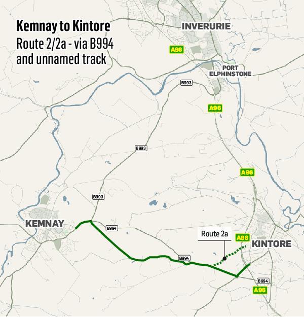
The council’s route option 2/2a plans for a new Kemnay to Kintore active travel route was most popular.
Safety was flagged by many as a major reason, because they thought locating the route away from a main road is the safest option.
By including the 2a section, it would avoid the roundabout and A96 Aberdeen to Inverness access roads.
This option’s distance would be about 5.3km (3.29 miles).
Kemnay to Kintore route option 3: 24.4% of the vote
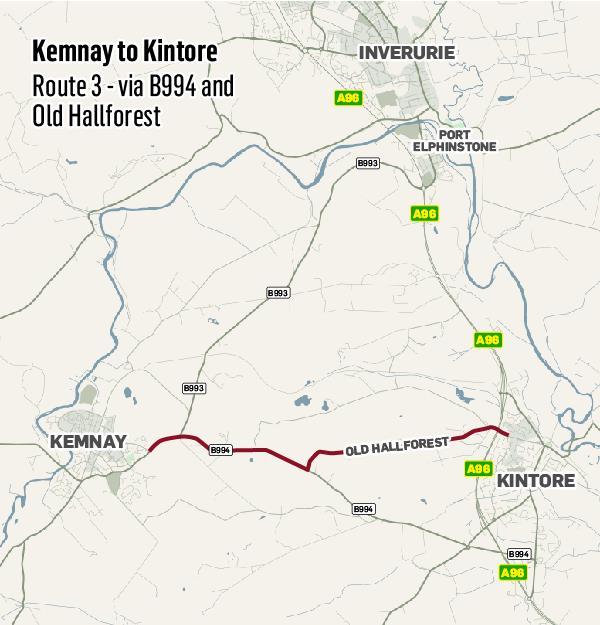
This route at about 5km (3.10 miles) would be the most direct of the three proposals for linking Kemnay and Kintore.
It would take users over the bridge over the A96.
It was deemed the most favourable by respondents who already cycle, as it “provided a quieter route than route 1, and entered Kintore in a convenient location”.
Council officer’s recommendation
Aberdeenshire Council officers have recommended members agree to “support further development for route option 2”, and accept a mix of routes 1 and 2 may be needed.
An officer’s report said: “There now needs to be further investigation into the chosen route (2) while taking on board all the comments raised by respondents to create a safe, direct segregated route from Kemnay to Kintore for all cycle users, especially young people.
“To achieve this, it may be required to create a hybrid route of route 1 and 2.”
The three Kemnay to Inverurie active travel route proposals
Kemnay to Inverurie route option 1: 11.3% of the vote
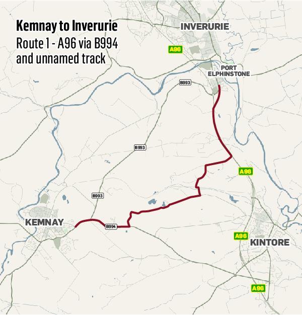
Of the three proposed active travel routes from Kemnay north to Inverurie, this was the least popular at just 11.3% of the vote.
At around 7.6km (4.72 miles), it would link in with existing walking and cycling infrastructure along the A96.
It is the longest of the three options.
Respondents said it’s too indirect a route, and safety fears were raised about crossing the A96.
Kemnay to Inverurie route option 2/2a: 28% of the vote
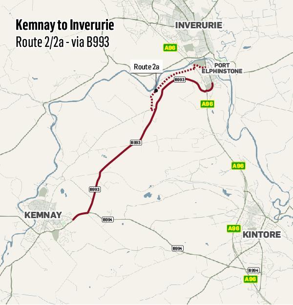
At 6.2km (3.85 miles), this was the most direct of the three routes.
Concerns were against raised that it would require crossing the A96, however the 2a path via a woodland would take travellers through a park and under the A96 into Inverurie.
It is considered a busier route for traffic.
Kemnay to Inverurie route option 3: 60.7% of the vote
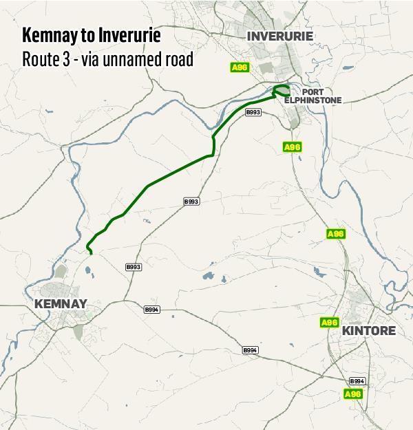
The final option of a 6.4km (3.97 miles) proved the most popular with 60.7% of the vote.
It’s considered to have less traffic than the route 2 option, and takes travellers under the A96 into Inverurie.
Respondents highly supported this choice as a “safe leisure and family route”, according to the council.
Council officer’s recommendation
Aberdeenshire Council officers have recommended councillors agree to support the development of route option 3.
A report by officers said: “As safety and the provision of a leisure route were deemed the highest priority for this route, route 3 meets the needs for many respondents and should be considered as the route to progress”.