They are maps divided by 40 years, but they illustrate how the German and Russian military machines created detailed plans of Aberdeen and other prominent locations in the north-east of Scotland.
Although the charts from the Second World War are written entirely in German, their subject matter is made clear from such chapter headings as “Blick von Queensferry uber die Forthbrucke” and “Bodenverhaltnisse im Hinterland und Firth of Tay”.
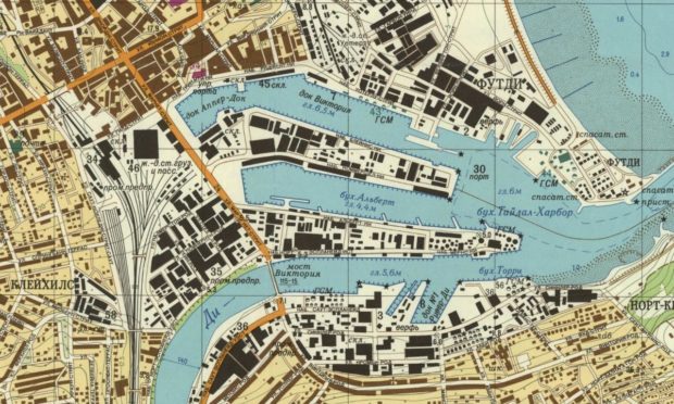
Then, four decades later, as tensions increased between NATO and the Soviet Union, before and after the invasion of Afghanistan at the end of 1979, a scale map of Aberdeen Harbour pinpointed in precise detail many of the architectural features which will be familiar to residents of the Granite City.
Precise measurements are given for the bridges over the Dee – the Victoria Bridge and Wellington Suspension Bridges have their lengths and widths accurately recorded – and a set of 58 “important objects” were numbered and named in the accompanying key.
They form part of the 93 known plans which the Russians created of UK cities and several of the charts appear in the book Scotland: Defending the Nation by Carolyn Anderson and Christopher Fleet, in association with the National Library of Scotland.
It takes us back to the days when the threat of military invasion and even nuclear annihilation cast a grim shadow over millions of ordinary people’s lives.
Bombs rained down on Tayside and the Granite City
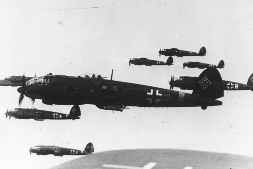
The preparation of these maps proved invaluable to the Luftwaffe, which regularly launched assaults across the north east of Scotland.
Dundee’s worst incident happened on November 5 1940 when a stick of four bombs came down on the city in what seemed to be a random attack by a German raider.
One crashed all the way through a four-storey tenement in Rosefield Street, killing two people and destroying the property and one of the bombs missed the Forest Park Picture House by only 20 yards. The venue was packed with children at the time.
During the period, Montrose experienced 10 air raids, the worst of which was on October 25 1940 when four Norwegian-based Heinkel 111s bombed the airfield.
Five men were killed, 21 were wounded and extensive damage was done to buildings and aircraft after the Montrose defences were caught completely off guard.
Aberdeen suffered grievously in the terror from the sky
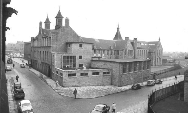
Aberdeen has long been considered one of the most strategic locations in the UK.
As a former stronghold of Scottish manufacturing with the country’s oldest working port and due to its key position in the North Sea, the Granite City was heavily bombed by the Luftwaffe and suffered a large toll of casualties, none more so than during the night of April 21 1943 when carnage struck the community.
In less than an hour, German aircraft dropped 127 bombs, damaging or destroying more than 12,000 homes and killing 98 civilians and 27 soldiers.
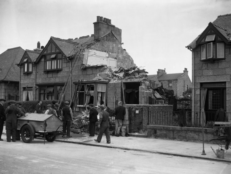
Between 1940 and 1943, Aberdeen was the most frequently bombed city in the UK, reportedly earning it the nickname Siren City.
In the previous decade, enemy agents gathered information about such places as Aberdeen, Dundee, Lossiemouth and Fife’s industrial communities to help the German army build up a picture of life on the ground which would assist a Nazi invasion.
One of the most notorious agents was Jessie Jordan who worked in espionage from a hairdressing salon in Dundee to help the Germans learn more about Tayside. Her exploits and subsequent incarceration in Perth Prison even persuaded some people to believe she was related to Adolf Hitler.
The Germans had detailed information about Scotland
The Nazi regime amassed a wealth of knowledge about a country they assumed would be forced to surrender in 1940.
The book authors said: “Their information was primarily drawn from British civilian topographic maps and photographs, supplemented by limited aerial reconnaissance.
“The photographs were often of key military targets with their locations shown on accompanying maps which described the nature of the coastline for an invasion from the sea. An accompanying land cover map was also drawn, showing the characteristics of the terrain for moving tanks and other armoured vehicles.”
They continued: “The German army was excellently briefed on the military geography of Britain and on its coastal defences.
“As part of its detailed reparations for potential invasion or occupation, they reprinted standard topographic mapping by Ordnance Survey.
“Ironically, the map includes a few features including the military aerodrome at Leuchars, which were subsequently erased from later OS mapping from the 1930s for censorship reasons, so the German map, which was obtained before the introduction of wartime restrictions, was more useful for wartime purposes.”
The RAF responded to the challenge, both in the air and through their intelligence network, allied to the assistance offered by little airbases which were dotted around the country, from Montrose and Moray to Orkney and Shetland.
But, as the authors have spelled out, it was still a damned close thing that they survived during these desperate months at the start of the conflict.
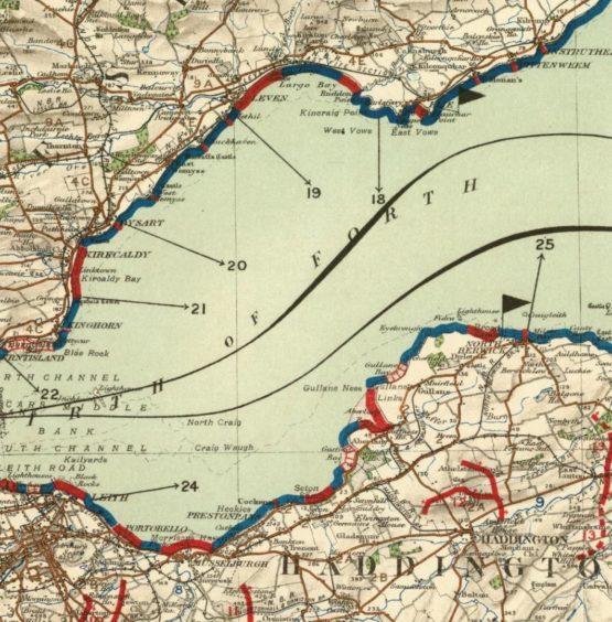
Even the Luftwaffe thought Fife was ‘suicide alley’
In the early part of the hostilities, the Scottish coast was bombarded on a regular basis, Other more heavily-populated communities such as Clydebank suffered appalling devastation from the German aircraft, especially in April 1941 when the Luftwaffe dropped 1,700 incendiary bombs and 270 tons of highly explosive munitions in the space of just two days, wreaking terrible havoc.
They also attempted – and failed – to destroy what was regarded as a key target in the Forth Bridge, which was, at that stage, the only structure across the river.
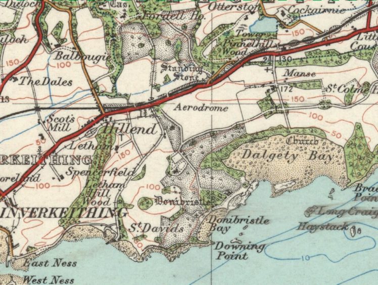
As months passed, the Luftwaffe pilots christened the Firth of Forth a “suicide alley”, a description which was partly due to the comprehensive artillery defences which guarded this important part of the coast and to the fighter aircraft stationed nearby at places such as Donibristle, Turnhouse and Montrose.
In the end, the Allies prevailed, but peace in 1945 didn’t ensure Britain’s security.
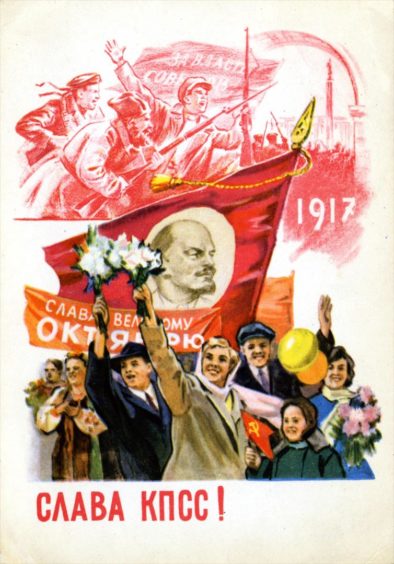
On the contrary, and as recently as the 1980s, there was another adversary to confront and the Cyrillic script in the map below highlights its origin.
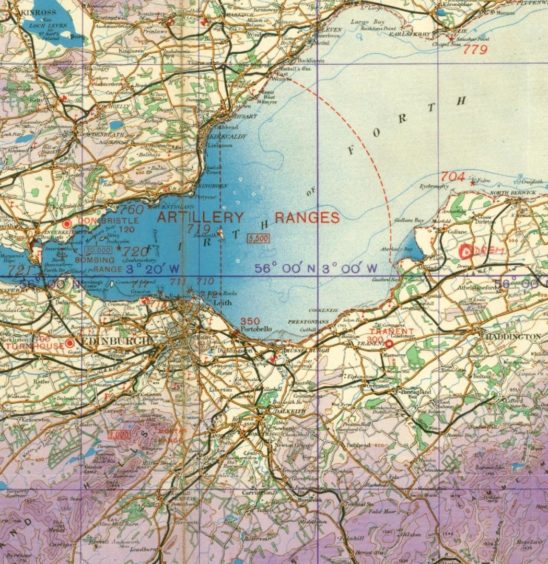
A Russian invasion was a possibility during the Cold War
Anybody familiar with Alan Bennett’s work will remember the 1983 BBC adaptation of his drama An Englishman Abroad, which was set in Moscow and featured as its lead character the infamous traitor Guy Burgess, played by Alan Bates.
In these days, there was no possibility of filming being allowed in the Russian capital, so the production team decided to find a substitute, which just happened to be Dundee.
The Caird Hall and the Whitehall Theatre were among the buildings decked out in Soviet memorabilia, prompting at least a few double-takes from baffled locals.
Yet, at that time of heightened international tension, there were genuine fears about a Third World War erupting between NATO and the Eastern Bloc countries.
And the map of Aberdeen Harbour demonstrates this wasn’t just paranoid fantasy.
The Russian army document included a long list of names familiar to Aberdeen residents – including Torry, Kincorth and Footdee – and provided clues as to how they might attempt an invasion of Europe’s oil capital in the event of another war.
The authors said: “We were surprised by the amount of detail and the precision of the map, but then Russian military maps are striking to behold, they are impressive in their detail, and also quite frightening in equal measure. The wealth of information it contains would surprise anyone.
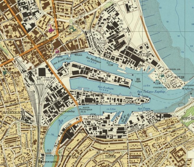
“Their description of Aberdeen and the surrounding area includes the statement: ‘The coastal region north [of the city] is suitable for amphibious landing. Numerous stone quarries, mainly of granite in Aberdeen suburbs, can be used as shelters.
“The landscape represents partly open coastal flatlands with patchy hills, directed by deep river valleys, which are the major obstacles for a non-road mobile machinery.
“Mud season lasts from April to October and, during this period, transport mobility is often hampered. But Aberdeen seaport is the major maintenance base for oil deposits in the North Sea. There are berthing facilities on both of the Dee’s banks and dockage facilities can provide the complete overhaul of vessels, including destroyers.”
Scotland has faced numerous military threats
The pages of Defending the Nation cover everything from Killiecrankie to Culloden, the French Revolution and the First World War and thence to the battle against Hitler.
It also includes an “Evacuation Map of Scotland” which was released on September 5 1939, which shows how seriously the British authorities viewed this option.
Mr Fleet said: “The evacuation planned to move 1.8 million people from the major conurbations and cities in Scotland out to rural areas over just two to three days.
“And here was a map of Scotland, which was barely the size of a postcard, with a few brief lines underneath it that calmly told everybody what was going to happen.”
Mikhail Gorbachev was feted in the Granite City
The collapse of the Soviet Union and Mikhail Gorbachev’s pursuit of glasnost eventually yielded an easing of relations in the early 1990s.
As the man who worked with the likes of former US president Ronald Reagan and British PM Margaret Thatcher, Gorbachev was rewarded for his efforts across Europe – and that included him being given the Freedom of the City in Aberdeen in 1993.
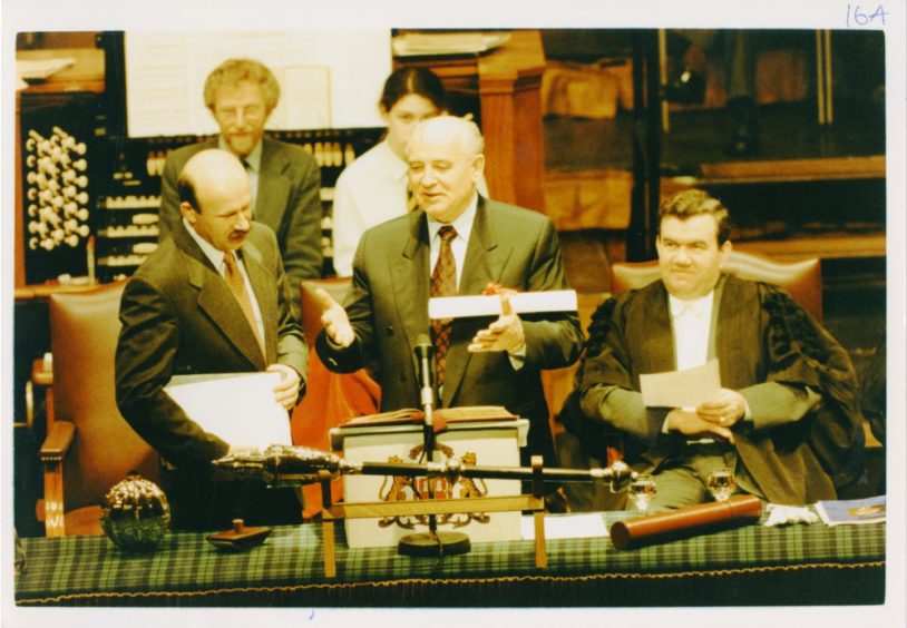
Such an accolade would have been unthinkable even a decade earlier, but the former Soviet leader flew from Hanover to Aberdeen on December 5 and a dinner was held in his honour at the city’s iconic Beach Ballroom.
The arrival of the man who helped end the Cold War created the phenomenon “Gorby-mania” in the Granite City.Even up to the night before the ceremony held in the Music Hall, callers swamped phone lines to the city council clamouring for the 1,000 free places in the now-vanished Capitol Cinema which was screening a live link to the historic event.
A massive transport operation swung into action to bring 5,000 schoolchildren to Union Street and they lined the pavements as Gorbachev took part in an official procession from the Music Hall to the Town House.
It was a far cry from the suspicion and hostility which surrounded Britian’s dealings with the Soviet Union at the start of the 1980s.
Scotland: Defending the Nation is published by Birlinn.
Jon S Baird’s new film will recreate Moscow in Aberdeen
Jon S Baird has been at the helm of several award-winning films in recent years, including Filth and the Bafta-winning Stan & Ollie.

And the Peterhead-born director has revealed that parts of Aberdeen will be transformed into Soviet-era Russia later this month as part of a Hollywood movie.
Mr Baird is bringing the cast and crew of Tetris, which includes Rocketman star Taron Egerton, to his home turf as filming continues on the big-budget movie.
The new work, which tells the story of the groundbreaking computer game’s creation in the 1980s, will lead to a number of roads around the city being closed, including the area around the Gallowgate’s Seamount Court.