Aberdeen’s Mounthooly roundabout, once said to be the biggest urban roundabout in Europe, has been perplexing drivers for decades.
It’s been 75 years since a roundabout and inner ring road were first proposed to alleviate Aberdeen’s increasing traffic problems.
And postwar, it was also seen as an opportunity to clear some of Aberdeen’s slum housing.
But from when it was first mooted in 1946 to the first tyres hitting the surface in 1977, it was a long, drawn-out process.
A huge infrastructure project that swept away a historic Aberdeen neighbourhood, Mounthooly roundabout was 30 years in the planning and six years in the building.
A close-knit community
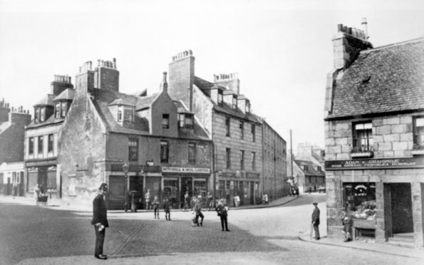
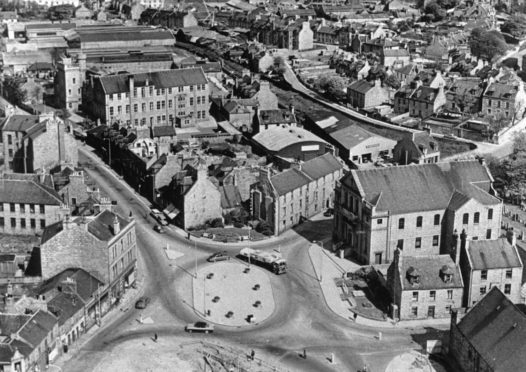
Mounthooly was always a busy crossroads; it’s where the Gallowgate met North Street, Nelson Street, Causewayend, Mounthooly and Hutcheon Street.
Around the meeting of roads on the edge of the city centre sprung a bustling and densely-populated community with the countryside beyond.
It was a mixed neighbourhood of factories and mills, a variety of shops, a large poorhouse, as well as churches, schools and a canal – later replaced by a railway.
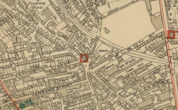
During the Victorian era, the arrival of the canal and related prosperity saw large, elegant houses built in nearby Canal Street and Canal Road.
The new turnpike road to Inverurie encouraged more traffic to the area, and the arrival of Catherine, Gerrard and Hutcheon Streets brought new junctions to the neighbourhood.
A busy, but close-knit community, Mounthooly even had its own dairy farm, a primary – Causewayend School – and in later years a little cinema.
Proposals for roundabout
A lot of traffic heading north out of the city centre went via Mounthooly and there were calls after the Second World War to make the area safer for pedestrians.
A traffic survey in 1958 found that 1,000 cars an hour were using Union Street – and that number was projected to double in the coming years.
Plans for a roundabout and improved road system were put forward by city leaders, but were knocked back several times.
As late as 1959, the Scottish Secretary refused Aberdeen Town Council permission to build a roundabout citing concerns that businesses would need to be demolished.
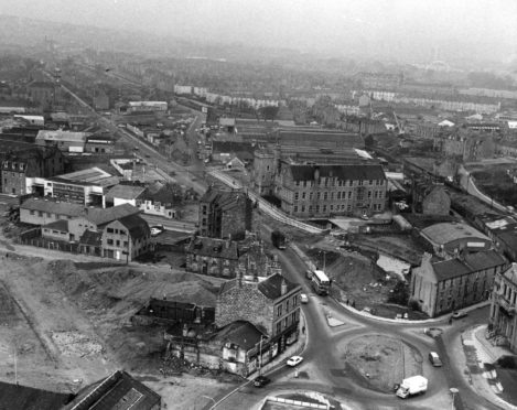
However, the plans were eventually agreed, and demolition was carried out to make way for a small roundabout.
A number of old shops and houses were knocked down on the Mounthooly-Nelson Street-West North Street corner.
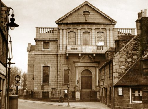
The final property to be flattened was a tenement in front of John Knox’s Church, revealing its facade for the first time in decades.
In 1960, a small roundabout was built at the meeting of the roads, a tentative step in improving mounting congestion and safety concerns.
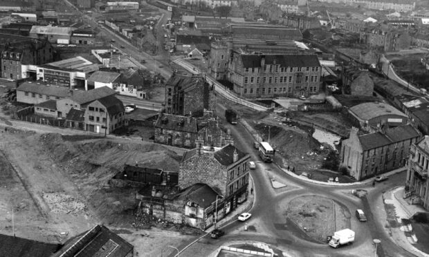
Demolition and desolation
But even the improved infrastructure couldn’t cope with the increasing level of vehicles in Aberdeen city centre.
A bigger, better roundabout was proposed along with a new dual carriageway to carry traffic through the city and beyond.
It was agreed that a new five-mile inner ring road – hailed as “the first new road near the city centre since the motor car was invented” – was required.
Although music to the ears of commuters, it was not welcomed by the community surrounding Mounthooly whose homes would need to be bulldozed to make way for the wider route.
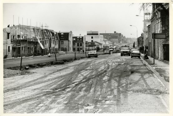
The plans would create three miles of new road stretching from Trinity Quay, along Commerce Street, crossing King Street and along West North Street to Mounthooly.
From here the dualled road would continue up Causewayend, Powis Terrace and part of Hutcheon Street with 130 homes earmarked for demolition.
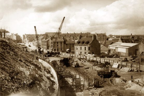
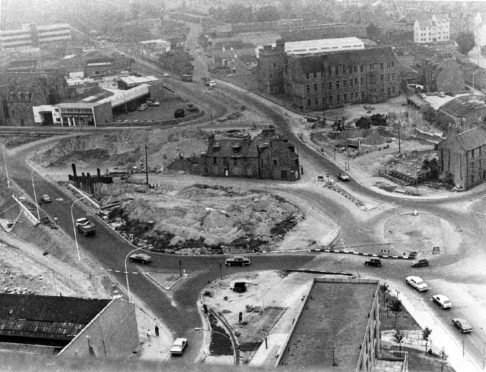
Work started in 1970, and by 1974, nearby residents were served with compulsory purchase orders.
Despite the heartache and uncertainty over losing their homes – many of them substantial granite buildings – locals were met with little sympathy when planners ran rough-shod over the community.
In fact, they were simply told “you have to break eggs to make an omelette”.
An eleventh-hour plea to save the homes at a council meeting in 1975 was overwhelmingly overruled by 20 votes to one.
Little was left of the historic community of Mounthooly, even the Lads’ Club was relocated to another part of the city.
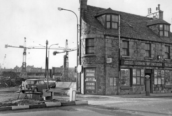
John Knox’s Church again survived the wrecking ball as did the former ‘Barry’s Cafe’, once a popular spot with the workforces of nearby granite engineering firms.
The newsagent and post office at 3a Causewayend, which had clung on until the end, was to move to the former cafe at 29 Mounthooly.
But by the time the clearances had taken place it was said Mounthooly “had an air of desolation about it”.
‘Made Rome seem like it was built in a day’
Work on the massive roundabout was still under way by 1974 – four years after construction started in 1970.
One city councillor likened the Mounthooly site to “the Mons battlefield” and another said “work stopped more often than the no.1 bus”.
And with a shortage of materials and continuing wrangles over some compulsory purchase orders, city engineers were vague with completion dates.
In 1975, the addition of two underpasses saw the costs jump from £295,000 to £382,000.
By 1976, staff at Causewayend School were starting to wonder if there would ever be an end to the dirt and disruption their young pupils were exposed to on a daily basis.
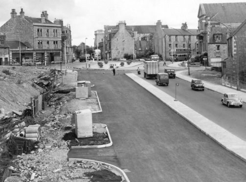
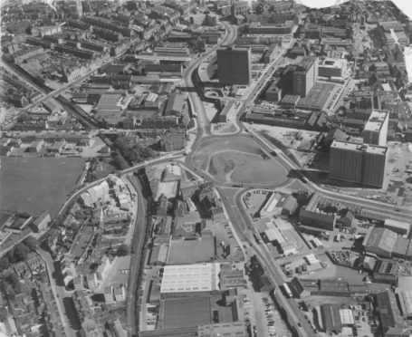
But the end was in sight by 1977 when the roundabout construction was finished, with just the onward dualled road to complete.
The finished Mounthooly roundabout was a colossal 2.5 acres in size – at the time, it immediately became Scotland’s biggest roundabout, and allegedly Europe’s biggest urban roundabout.
Such was its scale, that Aberdonians were told if it was planted entirely in grass there would be enough to keep two cows in feed for a year.
It was a feat of engineering billed as a new focal point for the city – albeit not a very attractive one – and featured the city’s biggest pedestrian underpasses.
But the length of time it took to complete still attracted ridicule, with many claiming it “made Rome seem like it was built in a day”.
By the time it was finished, it wasn’t really the ultra-efficient traffic-buster hoped for.
The volume of cars on the roads had increased substantially between the time it was planned and the time it was finished.
And the dualled sections end causing bottlenecks and frustration on Powis Place, Hutcheon Street and the Gallowgate.
Few drivers will be aware of the lost community of Mounthooly that once stood in place of the concrete and tarmac, it survives only as a memory.
See more like this: