Caisteal Dubh, Grandtully, Perth & Kinross
WITH the Easter school holidays fast approaching, those looking for a short walk that the whole family can enjoy should look no further than the mysterious Caisteal Dubh – the Black Castle.
This modest tree-wreathed hill near the Perthshire village of Grandtully – also known as Castle Dow – is the site of a prehistoric fort built by the Picts.
The summit commands a spectacular view over the surrounding countryside and the River Tay.
Important defensive position
It’s easy to see why this was regarded as such an important defensive position.
The stone ramparts were designed to keep out invaders, and also offered protection against wolves and bears.
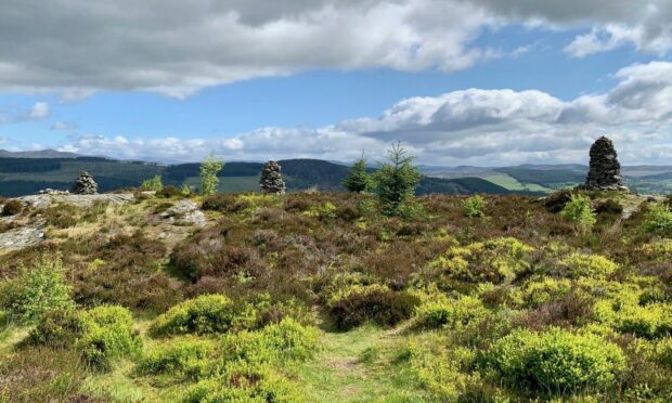
The summit hosts a line of large cairns along its crest. Most are believed to have been built in the 1800s, but the reasons for this more modern addition and who carried out the work remains a mystery now lost in the mists of time.
The walk is straightforward and shouldn’t prove too taxing. From the small forestry car park just off the B898 at Sketewan, check out the information board then take the rough track which rises gently in a series of twists and turns through a broadleaf woodland dotted with juniper and spruce.
Drystone wall
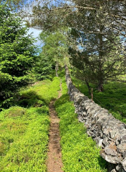
After about three kilometres on the track, watch for a narrow path running off to the right (there is a signpost but it would be easy to miss) which climbs between the trees to reach a drystone wall.
The path continues steeply, but briefly, uphill to the left of the wall to reach a breach in the stonework, an open doorway to the summit and its line of tall cairns.
The views in every direction are superb with the ubiquitous Schiehallion looking particularly fine. It’s a lovely spot to linger if the weather is kind, and the younger members of the party can let their imaginations run free.
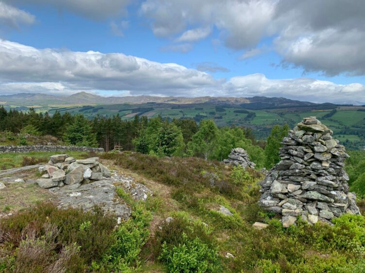
The lines of the ramparts are still clear enough in places but remains of the fort are scant, as are any signs of ancient hut circles and cup-marked stones .
Much of the stone has been stripped away over the years and put to other uses.
Retracing your steps is the recommended way back. It used to be possible to make a more circular return but the paths that cut off to the east have been obliterated by tree clearing, logging and a series of new high fences making this fairly impractical.
The very determined might still be able to find a way through, but in the interests of family harmony, it’s better to stick to the track.
Balnaguard Glen
For those who want a little extra treat, however, it’s worth making the short journey east to Balnaguard Glen, a small nature reserve created in 1976 and managed by the Scottish Wildlife Trust.
The glen follows a steep-sided gorge cut through by the Balnaguard Burn with a healthy cover of birch and juniper which is a hotspot for birdlife and butterflies.
Among the avian stars here are woodpeckers, sandpiper, woodcock and jays, while you may be lucky enough to spot a pine marten or a red squirrel.
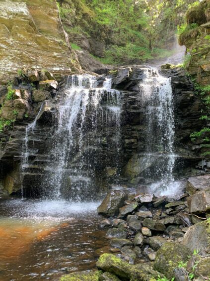
And deep in the woods there is one of the most delightful waterfalls I have had the pleasure of visiting, a hidden gem which suddenly appears through the canopy, a series of drops over rocky platforms with a final cascade into a pool from where the water dribbles down into the burn.
Idyllic spot
The walk in starts faintly through grass before turning down to weave between the trees. It then follows the burn beside an old moss-covered wall and crosses a wooden bridge over the water.
The path narrows for one last rise before the falls become visible from a gap in the trees. It’s an idyllic spot.
You can get down to the edge of the pool, but don’t be tempted to climb any higher on the slopes to the right – the best view is the one you already have. Return by reversing the inward route.
 ROUTE
ROUTE
1. From parking, head west past vehicle barrier on forestry track and follow as it turns back on itself, climbing steadily, twisting and turning in a southerly direction.
2. After about 3km, watch for path going off right (signpost) which climbs through trees to reach a drystane wall.
3. Follow narrow path uphill until it reaches a breach in the wall. Turn right through the gap to reach the line of cairns spread along the rocky summit crest.
4. Return by retracing your steps as recommended by the information board – it used to be possible to make a more circuitous descent, but tree felling, logging and new high fencing make this extremely unpleasant and inadvisable.
5. To visit nearby Falls of Balnaguard, drive the short distance east and turn right up the rough road at Balnaguard to a parking area before a bend. Directly across the track is a delightful path which leads through the trees and over a burn by a small bridge to reach the falls. Again, retrace your steps to the start.
INFORMATION
Distance: 8.6km/5.4miles
Ascent: 296m/972ft
Time: 2.5-4 hours
Grading: Easy walk with some ascent on woodland tracks and paths, suitable for all ages and abilities. Children will love the cairned hilltop and the falls, but take care near the water and the steep slopes. Muddy in places, good footwear advised. Dogs under close control near any farm livestock and in nature reserve.
Start/finish: Forestry car park west of Sketewan on B898 (Grid ref: NO 935525). For waterfall, Balnaguard parking area (Grid ref: NO 946517)
Map: Ordnance Survey 1:50,000 Landranger Map 52 (Pitlochry & Crieff); Ordnance Survey 1:25,000 Explorer sheet 379.
Tourist Information: VisitScotland, Pitlochry iCentre, 22 Atholl Road, Pitlochry, PH16 5BX (Tel 01796 472215).
Public transport: None to start points.
Conversation