Meikle Tap, Echt, Aberdeenshire
Hill of Fare is a bit of an imposter really, not so much a single hill as a spread of high rolling moorland and forestry embracing multiple tops.
Meikle Tap is one of those summits, the highest point in the eastern half of this sprawling expanse north of the busy Deeside town of Banchory, and it makes for a satisfying and energetic short outing.
The plethora of tracks that cover the area offer so many options to expand the day, although with the distances and backtracking involved approaches from the south and west are probably left for separate outings.
This mini circuit shouldn’t take more than a few hours even at a leisurely pace, and the height gain and angle of ascent should be within the reach of most casual walkers.
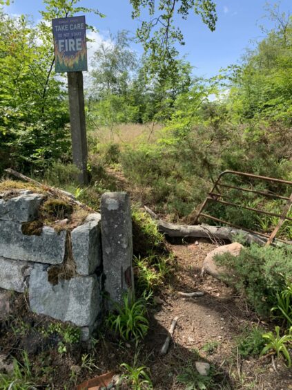
There is space for four or five cars in the rough layby on the left-hand side of the B977 about two kilometres south of Echt, and the starting point for the walk is through an old wall directly across the road. Take care when crossing as the traffic can be travelling fast here and the line of sight is not great.
A fallen rusting gate and fire risk sign are further clues to the entry point in the wall where a narrow path leads through mixed vegetation for a short distance before emerging at a forestry road.
The landscape appears a bit barren at this point, the tree cover having been recently cleared. Turn right, and follow the track round until it passes under power lines where a left turn leads to far more pleasant scenery through verdant woodland.

The switch was enlivened almost instantly by the sound of birdsong, and there were welcome flashes of colour with clumps of foxgloves thriving amongst the dripping greenery.
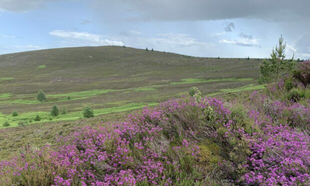
The colour scheme was further enhanced when the track emerged from the wood, swathes of pink and purple heather framing the slope of Meikle Tap filling the horizon off to the left.
This was the site of the Battle of Corrichie – named after the nearby burn – a short-lived clash in 1562 between the forces of George Gordon, 4th Earl of Huntly, and those of Mary, Queen of Scots, under James Stewart, 1st Earl of Moray.
The Gordons had superior numbers and had taken up positions on the lower slope where cavalry could not reach them but volleys of musket shot drove them down on to the marshy ground and their swords were to prove no match for the long pikes of Moray’s men.

Around 120 of their force of 500 were killed and 100 captured. The Earl of Huntly was one of the captives, but before he could be led away on his horse he collapsed and died.
The track heads west sticking to the edge of the forestry, and the heathery top of Greymore isn’t too far away with options to cut back through another section of forest, but for the shorter circular it’s better to turn left on the branch heading uphill.
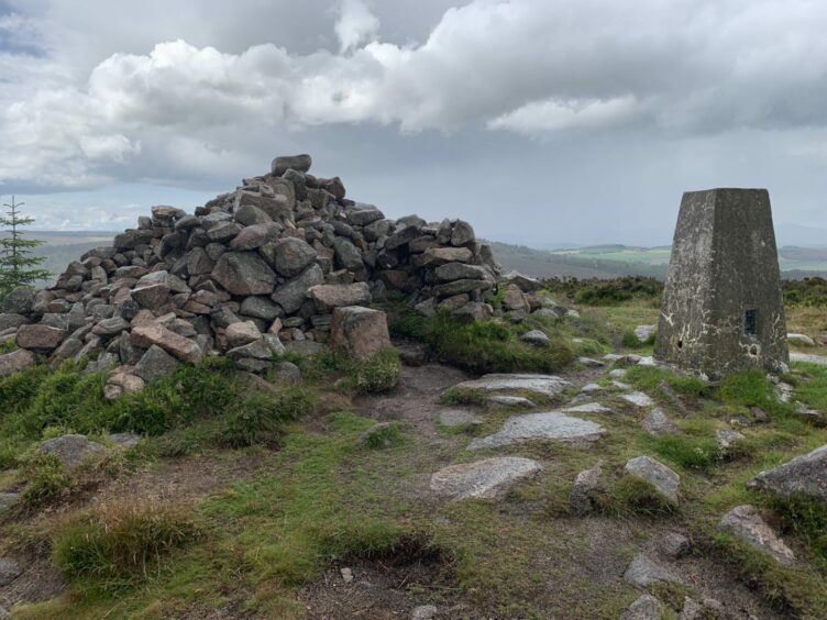
Another left turn at the next junction leads quickly and steadily to the top of Meikle Tap where there is a comms mast, a trig pillar and a large cairn with seated stone inserts at the four points of the compass so you can find shelter no matter which way the wind and rain is driving.
The descent path can be found just a few steps to the right of the trig pillar: turn left on the obvious path running across the hill through the heather. It’s muddy and waterlogged in places, but performs the task of getting you down the hill in good time.
Not long after passing a fence to your right, the path disintegrates further, becoming much rougher as it traces a twisting line between new-growth trees and old cleared sections with all the attendant debris.
You may even find it better to pick your own line in the latter stages to reach the forestry track which leads back to the initial entry point.
ROUTE
Cross road and go through wall beside fallen gate and pick up path through woods to emerge at track crossroads.
Turn right following forest road which bends left until passing under electricity lines, then turn left on to track heading gently uphill between trees.
Continue straight ahead following edge of tree line with views left to Meikle Tap.
When track splits, take branch which turns left, climbing steadily south.
At next junction, turn left and walk up to summit of Meikle Tap, which is crowned by a large cairn, trig pillar with a comms mast nearby.
Leave summit going south on path which quickly joins another one running across hillside. Turn left and drop down wide and heathery east ridge to reach treeline.
Stick with path as it narrows and twists downhill through trees and felled sections to link with forestry track, then turn left and follow back to junction and initial path out to road.
INFORMATION
Distance: 7km/4.5miles
Ascent: 283m/930ft
Time: 2-3 hours
Grading: Short circuit on tracks and hill paths to a fine moorland viewpoint with continual steady ascents, suitable for anyone with reasonable level of fitness. Muddy in places, some fallen trees and debris, strong footwear advised.
Start/finish: Rough layby on left side of B977 2km south of Echt (Grid ref: NJ 743039).
Map: Ordnance Survey 1:50,000 Landranger Map 38 (Aberdeen); Ordnance Survey 1:25,000 Explorer sheet 367.
Tourist Information: VisitScotland Aberdeen iCentre, 23 Union Street, Aberdeen, AB11 5BP (01224 269180).
Public transport: Bus service to Echt (A2B).