Calendar An icon of a desk calendar. Cancel An icon of a circle with a diagonal line across. Caret An icon of a block arrow pointing to the right. Email An icon of a paper envelope. Facebook An icon of the Facebook "f" mark. Google An icon of the Google "G" mark. Linked In An icon of the Linked In "in" mark. Logout An icon representing logout. Profile An icon that resembles human head and shoulders. Telephone An icon of a traditional telephone receiver. Tick An icon of a tick mark. Is Public An icon of a human eye and eyelashes. Is Not Public An icon of a human eye and eyelashes with a diagonal line through it. Pause Icon A two-lined pause icon for stopping interactions. Quote Mark A opening quote mark. Quote Mark A closing quote mark. Arrow An icon of an arrow. Folder An icon of a paper folder. Breaking An icon of an exclamation mark on a circular background. Camera An icon of a digital camera. Caret An icon of a caret arrow. Clock An icon of a clock face. Close An icon of the an X shape. Close Icon An icon used to represent where to interact to collapse or dismiss a component Comment An icon of a speech bubble. Comments An icon of a speech bubble, denoting user comments. Comments An icon of a speech bubble, denoting user comments. Ellipsis An icon of 3 horizontal dots. Envelope An icon of a paper envelope. Facebook An icon of a facebook f logo. Camera An icon of a digital camera. Home An icon of a house. Instagram An icon of the Instagram logo. LinkedIn An icon of the LinkedIn logo. Magnifying Glass An icon of a magnifying glass. Search Icon A magnifying glass icon that is used to represent the function of searching. Menu An icon of 3 horizontal lines. Hamburger Menu Icon An icon used to represent a collapsed menu. Next An icon of an arrow pointing to the right. Notice An explanation mark centred inside a circle. Previous An icon of an arrow pointing to the left. Rating An icon of a star. Tag An icon of a tag. Twitter An icon of the Twitter logo. Video Camera An icon of a video camera shape. Speech Bubble Icon A icon displaying a speech bubble WhatsApp An icon of the WhatsApp logo. Information An icon of an information logo. Plus A mathematical 'plus' symbol. Duration An icon indicating Time. Success Tick An icon of a green tick. Success Tick Timeout An icon of a greyed out success tick. Loading Spinner An icon of a loading spinner. Facebook Messenger An icon of the facebook messenger app logo. Facebook An icon of a facebook f logo. Facebook Messenger An icon of the Twitter app logo. LinkedIn An icon of the LinkedIn logo. WhatsApp Messenger An icon of the Whatsapp messenger app logo. Email An icon of an mail envelope. Copy link A decentered black square over a white square.

Rare maps to be seen on Shetland for first time

Robetson's map of Kingston, Jamaica

Rare colonial maps created by a famous son of Shetland will be the centrepiece of a new exhibition launching today in the island’s capital.

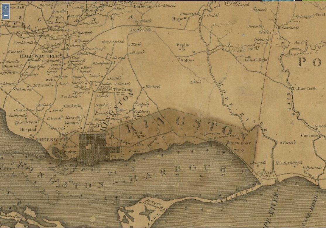
James Robertson was born on the island of Yell in 1753 and emigrated to Jamaica where he produced the first full map of the Caribbean island.

The National Library of Scotland has loaned the maps, which have never been seen before on the islands.

The exhibition James Robertson: The Shetlander who Mapped Jamaica (1753 – 1829) opens at the Shetland Museum and Archives in Lerwick and will run to November 22.

It illustrates Robertson’s life and work and also presents a rare opportunity to view original maps by the cartographer.

From 1796-1804, Robertson compiled the first detailed maps of Jamaica. They were remarkably accurate, even by today’s standards, and an excellent insight into the island, then an important British colony and sugar exporter.

Robertson later returned to Britain, where he compiled a detailed map of the north-eastern counties of Scotland in 1822, which shows a rural landscape undergoing big changes.

The exhibition also features unique artefacts illustrating the practical surveying equipment that Robertson would have used, correspondence with him, and original documents relating to his map of north-east Scotland.

Chris Fleet, map curator at the National Library of Scotland, said: “Robertson’s maps of Jamaica allow us to visualise this British colony at the height of the sugar industry, and Robertson’s cartography was an important means for maintaining order and control of territory. There were also important links with Scotland too, with many of the sugar estates owned by Scots, whose names and plantations are clearly shown on Robertson’s maps.”

Local primary school pupils will have the opportunity to learn more about map making in workshops during the exhibition.

There will also be family workshops, as well as art classes and reminiscence sessions.