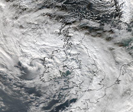
Roaring winds could down trees, cause power cuts and lead to flooding as Storm Barney sweeps through the UK this week, however, the most recent satellite image suggest the north of Scotland could be the only place in the UK to avoid the storm.
The second storm deemed strong enough to be given its own name this season is expected to bring winds of up to 75mph to areas across the south of England, as well as Wales and Ireland through Tuesday night.
Weather experts are also predicting heavy rainfall in Northern Ireland, Wales and north-west England as well as the strong winds, which could disrupt flights from Heathrow and Gatwick airports, as well as other transport.
AccuWeather meteorologists have predicted rainfall from Barney to generally total around 25 mm (1 inch), but as much as 50 mm (2 inches) may fall in some areas.
Meteorologist Eric Leister said: “Barney will be a fast-moving storm, bringing locally strong winds to southern Ireland and the southern UK beginning midday Tuesday and continuing into Tuesday night.”
A yellow “be aware” warning for strong winds has been issued for parts of Wales, southern, central and eastern England for this afternoon and into the evening, as a series of low pressure systems move in from the Atlantic bringing unsettled weather.
There is also a weather warning for rain in the next few days centred on the north west of England and Wales, coming hard on the heels of torrential rain which saw rivers burst their banks and localised flooding affecting roads, farmland and train services.
The Met Office is warning that given the already saturated conditions, communities could see more floods from standing water or swollen rivers that could lead to travel disruption.
The strongest winds were expected across the Western Isles and north-west coast, before easing over the course of today.
There is due to be a change in the weather at the end of the week with colder air spreading from the north, bringing wintry showers to the northern UK, particularly over the hills.
Despite the threat of more bad weather, the Environment Agency said the flood risk across northern England was receding – although river levels will remain high in the week ahead.
In particular, the River Ouse in North Yorkshire and York will remain high until Thursday, where there could be further localised flooding, the agency said.
Elsewhere, many flood warnings for rivers have been removed, although 22 are still in place, along with dozens of flood alerts.
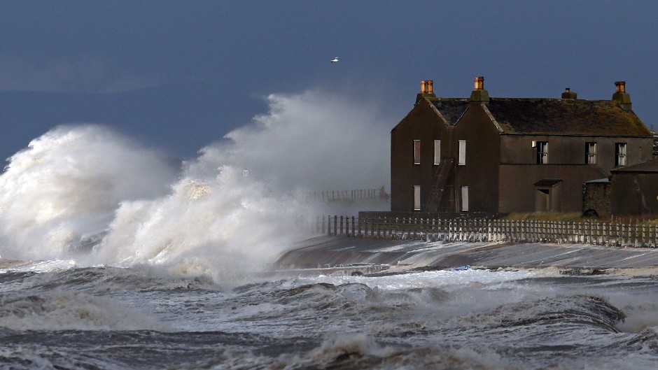
Gale and severe gale force westerly winds which will hit parts of the UK as Storm Barney comes in are expected to generate large waves around exposed coasts in south-west England and the English Channel.
But while some localised spray and waves coming over sea defences is possible, the overall coastal flood risk is very low, the Environment Agency said.
More than 20,000 homes were protected by Environment Agency flood schemes this weekend, according to the organisation which deployed more than 600 metres (2,000ft) of temporary defences with the help of 20 military personnel, to protect homes at Braystones, Whalley, Warwick Bridge and Ribchester.
Craig Woolhouse, director of incident management at the Environment Agency, said: “The flood risk will recede across northern England over the coming days, although river levels will remain high.
“The public should remain alert to the risk of flooding and stay away from raging rivers. With so much standing water around, we ask people to stay out of flood water and not attempt to walk or drive through it.”
RAC spokesman Simon Williams said: “Barney will affect drivers further south than Abigail did, so many will be having to deal with their first real dose of strong autumn winds. We urge anyone on the road in the thick of the storm to slow down and leave plenty of space behind the vehicle in front.
Motorists should resist the temptation to drive through standing water unless they are sure it is shallow enough to get through safely, otherwise it could prove to be a very costly mistake.”