Calendar An icon of a desk calendar. Cancel An icon of a circle with a diagonal line across. Caret An icon of a block arrow pointing to the right. Email An icon of a paper envelope. Facebook An icon of the Facebook "f" mark. Google An icon of the Google "G" mark. Linked In An icon of the Linked In "in" mark. Logout An icon representing logout. Profile An icon that resembles human head and shoulders. Telephone An icon of a traditional telephone receiver. Tick An icon of a tick mark. Is Public An icon of a human eye and eyelashes. Is Not Public An icon of a human eye and eyelashes with a diagonal line through it. Pause Icon A two-lined pause icon for stopping interactions. Quote Mark A opening quote mark. Quote Mark A closing quote mark. Arrow An icon of an arrow. Folder An icon of a paper folder. Breaking An icon of an exclamation mark on a circular background. Camera An icon of a digital camera. Caret An icon of a caret arrow. Clock An icon of a clock face. Close An icon of the an X shape. Close Icon An icon used to represent where to interact to collapse or dismiss a component Comment An icon of a speech bubble. Comments An icon of a speech bubble, denoting user comments. Comments An icon of a speech bubble, denoting user comments. Ellipsis An icon of 3 horizontal dots. Envelope An icon of a paper envelope. Facebook An icon of a facebook f logo. Camera An icon of a digital camera. Home An icon of a house. Instagram An icon of the Instagram logo. LinkedIn An icon of the LinkedIn logo. Magnifying Glass An icon of a magnifying glass. Search Icon A magnifying glass icon that is used to represent the function of searching. Menu An icon of 3 horizontal lines. Hamburger Menu Icon An icon used to represent a collapsed menu. Next An icon of an arrow pointing to the right. Notice An explanation mark centred inside a circle. Previous An icon of an arrow pointing to the left. Rating An icon of a star. Tag An icon of a tag. Twitter An icon of the Twitter logo. Video Camera An icon of a video camera shape. Speech Bubble Icon A icon displaying a speech bubble WhatsApp An icon of the WhatsApp logo. Information An icon of an information logo. Plus A mathematical 'plus' symbol. Duration An icon indicating Time. Success Tick An icon of a green tick. Success Tick Timeout An icon of a greyed out success tick. Loading Spinner An icon of a loading spinner. Facebook Messenger An icon of the facebook messenger app logo. Facebook An icon of a facebook f logo. Facebook Messenger An icon of the Twitter app logo. LinkedIn An icon of the LinkedIn logo. WhatsApp Messenger An icon of the Whatsapp messenger app logo. Email An icon of an mail envelope. Copy link A decentered black square over a white square.

First snow of the season could fall on highest peaks this weekend

The four students got into difficulty on Ben Macdui

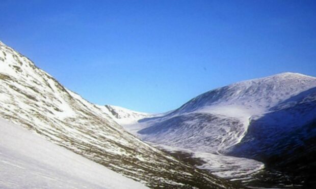
Autumn snow is expected on the north’s highest peaks this weekend as temperatures take a tumble.

The Met Office said areas above 3,000ft could start to see “wintry precipitation” from tonight.

Rain coupled with lower temperatures could cause the first snowfall of the back end of year at higher altitude.

Forecasters said the weather was returning to more average conditions, compared with an unusually dry and warm September.

A Met Office spokesman said: “People will definitely notice it is in feeling cooler in the next few days.

“It will certainly be cold enough at a certain heights for the forecast rain to turn wintry, probably somewhere between 800m (2,624ft) and 1,000m (3,280ft) by Friday night.

“The rain will probably fall as some form of wintry precipitation which could be sleet, hail or snow.

“I wouldn’t expect anything too serious apart from the highest peaks though.”

Yesterday saw a definite shift in the weather as gale force winds battered the Western Isles and north-west coast.

Ferries were cancelled between the mainland and the Western Isles, as well the ferry between Mallaig and Armadale on Skye due to gale force winds. The Skye Bridge was closed to high sided vehicles for a time too.

Forecasters have warned that the high winds and heavy rain are likely to continue to cause disruption throughout today in the north-west of the country, as well as Orkney and Shetland.

The Met Office spokesman added: “It will be cooler, with colder air following the rain and wind in from the west.

“That will be a trend for the next few days.”

Flood rescue team AA Special Operations is warning of the risk of flash flooding from today in northern and western areas.

Rescue team boss Darron Burnes said: “We could see upwards of 60mm (2.3in) rain and gusts up to 60mph in places.

“While river catchments may well be able to take this volume of water after the very dry September, a lot may fall within 12 to 24 hours, so flash flooding is likely to be the main issue for drivers in the affected areas.

“Friday evening’s rush hour could be particularly affected, so allow a bit more time if you’re heading away for the weekend and check your car’s lights and wiper blades.”