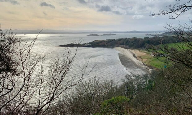
There’s usually one moment in every walk which takes you by surprise, when all the elements are brought together to present a perfect pictorial summation of the day.
I was making my way east through The Heughs, a thin strip of woodland above Aberdour, when there was a break in the trees that allowed a spectacular uninterrupted view back along the coast.
A perfect view
Every contour was pin sharp in silhouette and the atmospherics were perfect too: a metallic sheen on the waters of the Forth, winter sky with pastel tinges and puffs of static cloud, the glowing beach of Silversands living up to its name.
It was a peaceful interlude on a day when this corner of southern Fife was one of the few places likely to be enjoying a sunshine window while most of the rest of the country was on storm alert.
Aberdour started life as two villages – Easter and Wester Aberdour – around a natural harbour.
In the 14th Century, Robert the Bruce granted these lands, which included Aberdour Castle, to the Earl of Moray. It later passed to the Earls of Morton.
The twin villages were a hub for industries such as weaving, coal and salt.
Coastal mecca
In the Victorian era, Aberdour’s favourable coastal position saw it become a mecca for tourists, a reputation further cemented when the Forth Bridge opened in 1890.
Its two beaches – Silversands and Black Sands – are still a big attraction.
I started from the railway station where there is a large car park (no charge) serving the village, and headed along the A921 before turning left up Murrel Road.
When the tarmac ended, I continued on a muddy path between hedges and fields.
The path ended at a fence where I stepped over the low fence to the right, then a gate to the left before heading right on a clear passageway through the swathe of gorse.
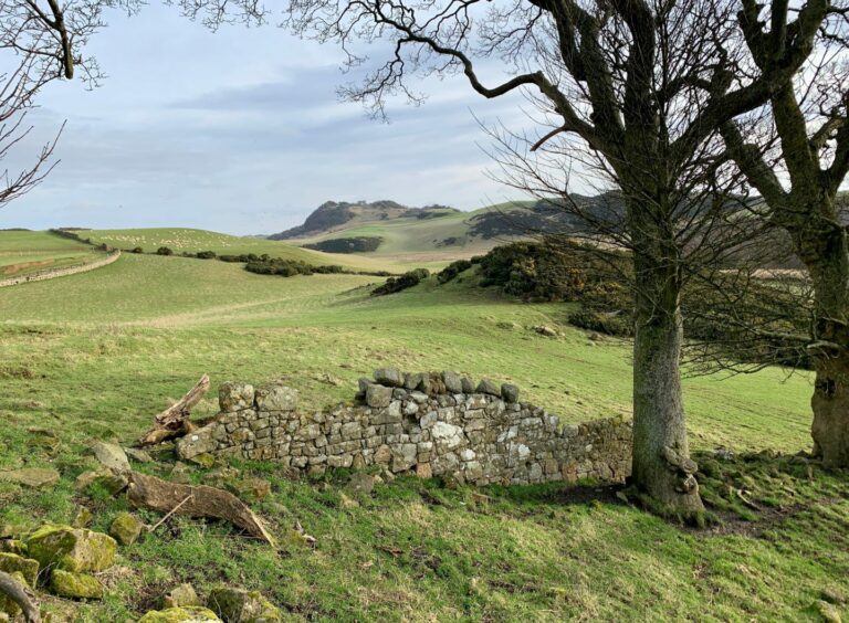
I soon emerged on open ground, where another gate led to the ruin of Balram.
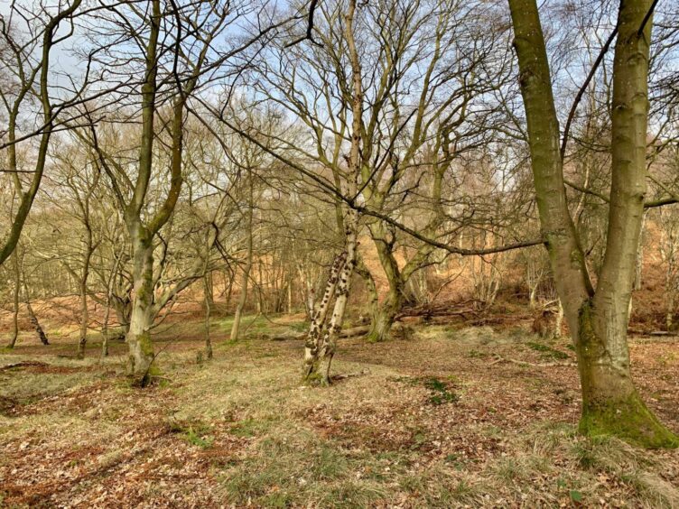
With The Binn directly ahead, the route dropped to the right and tracked round the edge of Humbie Wood before a gate allowed access into the trees.
The wood is used for pheasant rearing and there are pens and feeding stations throughout.
Along the burn
The path was vague at first but soon improved, following the line of the burn before taking a turn left and heading to the exit on the southern edge.
After a careful crossing of the A921, I was almost immediately back into woodland, this time a lovely ribbon of greenery running above the rail line.
This eventually dropped down steps and through an underpass to join the Fife Coastal Path.

The surfaced track swept round Silversands and then Hawkscraig Point before turning towards the harbour.
The route would normally continue further round but a pedestrian bridge has been washed away so I headed uphill following diversion signs round by the castle.
It is hoped the bridge will be back in commission later this year.
Medieval ‘ leper squint’
There was time to take a closer look at the castle ruins – access is limited due to restoration work – and the 12th Century St Fillans Church.
As with so many medieval churches, it features a ‘leper squint’, a tiny window that allowed lepers to watch Mass apart from the general population.
This is said to be where Robert the Bruce gave thanks for his victory at Bannockburn in 1314.
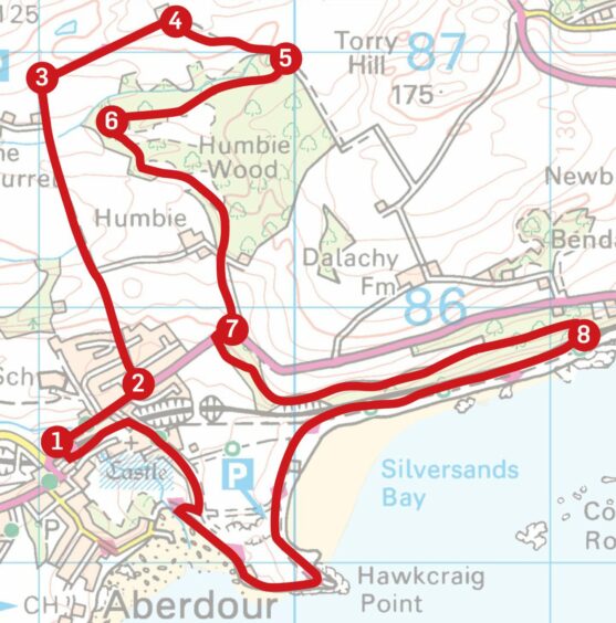 ROUTE
ROUTE
1. Exit station car park and turn right along A921, then left up Murrel Road.
2. At end of houses, continue ahead on muddy path between fields, which passes through couple of gates and ends at fence below gorse hillside. Step over low fence to right and immediately over gate on left.
3. Take first right on path through gorse which leads to more open ground, then go through gate to ruined buildings at Balram.
4. Turn right (arrow on tree) and follow grass track across field which runs along edge of wood, passing through couple of gates.
5. After track swings right, go through metal gate on right into wood. Faint path follows edge of pen at first before dropping left (indistinct) to join more obvious path. Keep right at any junctions, staying just above burn on your right.
6. Eventually path swings round to left, crossing small rise then another burn before emerging from wood on to farm track which leads down to A921.
7. Cross to pavement and go right, then first left into trees (at Welcome to Aberdour sign). When path splits, take left branch heading uphill. At signpost turn right (for Starleyburn) and follow path down to steps leading to rail underpass.
8. Go through and turn right on to coastal path. Follow around Silversands and Hawkscraig Point and then along towards harbour. NB: Route is closed here due to damaged footbridge, so take diversion following coastal path signs uphill then round by castle to station.
INFORMATION
Distance: 10km/6.5miles
Ascent: 240m/775ft
Time: 2.5-3.5 hours
Grading: Pleasant circuit through two woodland sections linked by paths, field edges and minor roads, suitable for all ages and fitness levels. Couple of brief pavement sections on main road, inward route is by Fife Coastal Path. Muddy in places, sturdy footwear advised. Farm livestock will be encountered, dogs under close control.
Start/finish: Aberdour rail station (Grid ref: NT 190854). Note: Toilet facilities only available from 06.45-09.45.
Map: Ordnance Survey 1:50,000 Landranger Maps 65 (Falkirk & Linlithgow) and 66 (Edinburgh); Ordnance Survey 1:25,000 Explorer sheet 367.
Tourist Information: VisitScotland, St Andrews iCentre, 70 Market Street, St Andrews, KY16 9NU (Tel 01334 472021).
Public transport: Regular bus and train services to Aberdour.
Conversation