Mona Gowan, Aberdeenshire
Mona Gowan is the highest point along a chain of rolling heather hills located to the east of the A939 between Glen Gairn and Strathdon.
Standing at 749 metres, it is classed as a Graham, but when climbed from the high point of the Old Military Road, it’s a relatively leisurely day out, the ascent having been reduced to little more than half its height. And as is often the case with these lower Cairngorms outliers, the feeling of space and solitude is immense.
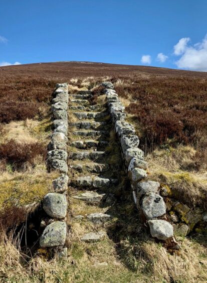
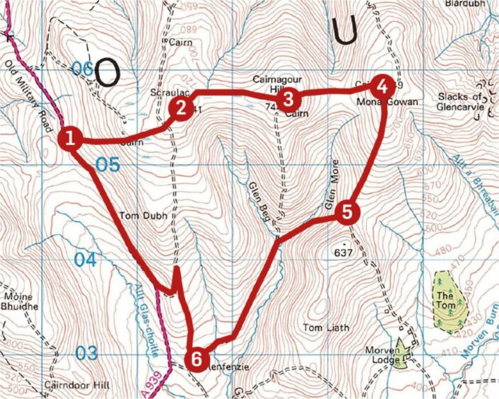
Finding the correct layby to start from is also easy – it’s the one on the right heading north with a set of old stone steps heading up into the heather. From the top of the staircase, a narrow path is picked up which climbs beside the line of a fence, developing all the way.
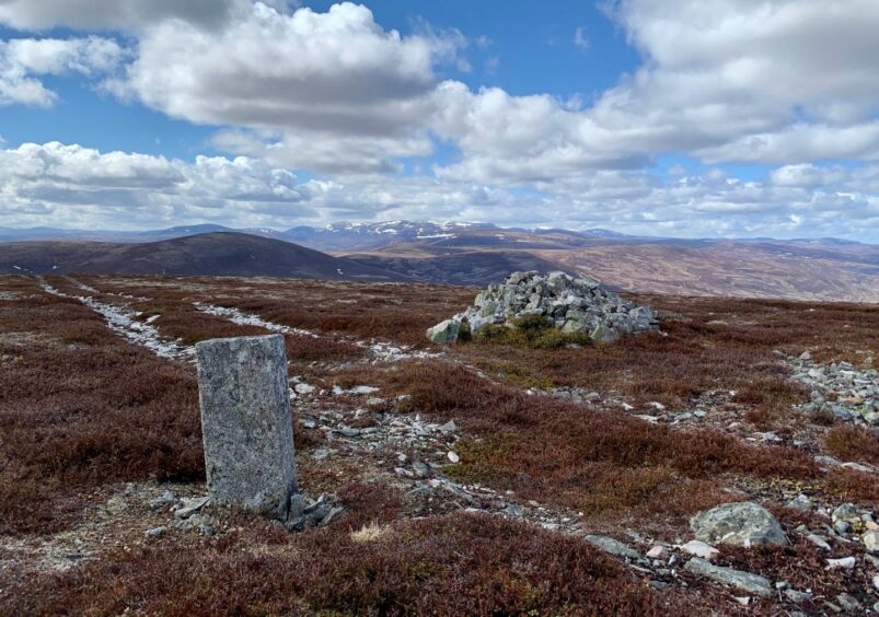
Higher up, the path becomes a track and the going gets easier, leading to the cairn and standing stone which mark the top of Scraulac, the first summit of the day.
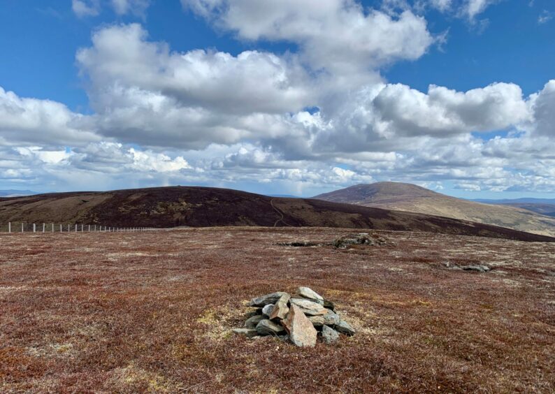
The views west to the higher Cairngorms are magnificent, especially when they are capped with the last remnants of snow, and they just keep getting better as you make your way round the circuit.
Cairnagour Hill is next up. It can be boggy and wet at the col between the two, but the going is gentle and the angle of the rise to this undistinguished summit won’t strain the muscles too much. A small cairn marks the highest point, with a larger one just further along the flat plateau.
The drop to the next col is much steeper as you follow the fence closely down through sometimes deep heather but the angle eases for the steady climb up to the main attraction.
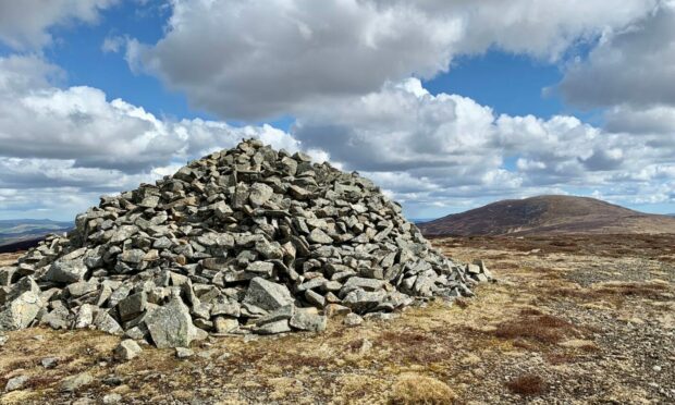
There is some debate over the name Mona Gowan – it’s either ‘goat moor’ or the ‘hill-moss of the smith’ – but there is no mistaking its summit.
The massive pile of granite boulders which crowns this hill was built in 1887 by General Sir John Forbes and tenants of the area to celebrate the Golden Jubilee of Queen Victoria’s reign. At one time, the cairn was adorned by a granite tablet detailing its construction but that has long fallen victim to time and the elements.
There is a school of thought that retracing your steps from this summit is the best return option, especially as you have the constant of the Cairngorms spread across the horizon in front of you most of the way back.
Meanwhile, those who fancy a longer and harder day can continue on the current trajectory over the Slacks of Glencarvie towards the impressive presence of Morven before dropping south from the Corbett to the Marquis of Huntly’s Well, then returning east via a series of track junctions.
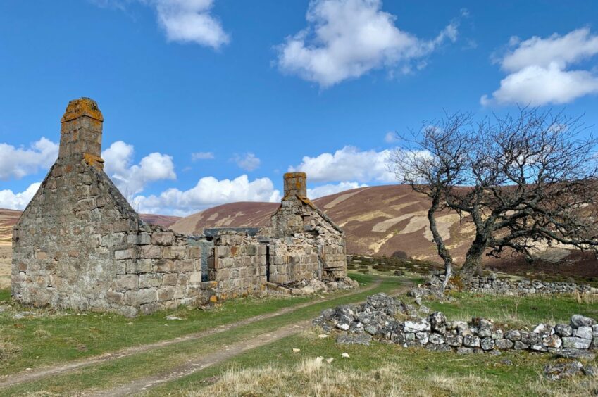
My choice was somewhere between the two. I dropped south from Mona Gowan into Glen More and then turned right at a track junction which led over the side of Tom Liath and crossed the water at the foot of Glen Beg before walking down to the ruined farm buildings and old sheepfolds at Glenfenzie.
The track heads out on to the A939, but I decided to turn right before the gate and follow the track heading uphill. This leads all the way back to a point just below Scraulac, but that kind of defeats the purpose of the high starting point.
Instead, after about a kilometre, look for a gate on the left. Go through and take the track cutting back downhill. This soon turns sharply right to emerge on the road for 20-minute or so yomp back to the high point.
The road is generally quiet, although traffic does travel fast, but there is plenty notice of approaching vehicles to allow a hop onto the verges.
ROUTE
Climb flight of stone steps from layby and head uphill on path through thick heather to right of fence line, then higher up cross fence to reach cairned summit of Scraulac.
Continue east by fence line, dropping to boggy col and then climbing again to top of Cairnagour Hill.
Drop again through heather to another boggy col before climbing more steeply to the huge summit cairn on Mona Gowan.
Head south-west down open slopes beside a fence and a line of grouse butts to join a track and when you reach a junction, head right.
This cuts across the foot of slopes of Tom Liath to reach a ford at the foot of Glen Beg then continues down to the ruined farmhouse of Glenfenzie.
To return, just before a metal gate turn right on a wide path heading uphill. When you reach another gate on the left, go through on to a track which leads down to the A939 for the 1.5km walk up the road.
As an alternative, you can go through the first gate for the longer walk up the A939. The fitter may even opt to keep going on the path back to Scraulac.
INFORMATION
Distance: 11km/7mls
Ascent: 492m/1614ft
Time: 3-4hours
Grading: Easy high-level circuit with steady ascent following estate tracks, hill paths, with sections of pathless walking. Suitable for walkers with decent level of fitness. Deep heather and rough, boggy ground at times, good footwear essential. Sheep may be encountered on the open hill – dogs under close control.
Start/finish: Layby at high point of Old Military Road A939 (Grid ref: NJ 303052).
Map: Ordnance Survey 1:50,000 Landranger Map 37 (Strathdon & Alford); Ordnance Survey 1:25,000 Explorer sheet 58.
Tourist Information: VisitScotland, Ballater iCentre, Station Square, Ballater, AB35 5QB (Tel 01339 755306).
Public transport: None to start point.
Conversation