The urban sprawl of 20th Century Aberdeen quickly enveloped the smaller, older communities which had grown around industry and the railway.
The Granite City we know today spans two rivers and has encompassed many traditional communities, stretching from Cove Bay in the south, Peterculter in the West and Dyce to the north.
Buildings may have come and gone, but it’s only from the air that the changes and growth in Aberdeen over the decades are most visible.
Join us as we take a look at the old communities of Aberdeen through our striking aerial archive photos.
Old Aberdeen
The Granite City grew out of two different communities. Old Aberdeen was a centre for religion and scholars dating back to the 14th Century, while New Aberdeen in the harbour area was a hub for trade and commerce.
A visit to quaint and beautiful Old Aberdeen is like a step back in time, with its picturesque cobbled Chanonry leading to St Machar’s Cathedral.
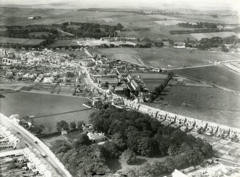
In this photo below, taken from an aircraft during the 1930s, the magificent King’s College building of the University of Aberdeen campus is just visible at the bottom.
The three roads leading up from it – Elphinstone Road, College Bounds and Dunbar Street – were surrounded by fields.
Nowadays, the land on either side of the three roads is occupied by university buildings, while King Street on the far right is much busier.
St Machar’s Cathedral sits near a bend in the River Don towards the north, with the long-gone Seaton House peeking through the trees at the top.
Woodside
Woodside looks every inch the country community, below, in this pastoral view from the 1930s.
The villas of Clifton Road can be seen on the bottom left next to Cotton Lodge and its extensive grounds.
The lodge and its gardens have long-since disappeared under Primrosehill Drive and Gardens, but the smart houses of Great Northern Road are still recogniseable on the right.
Further up, you can see the fork in the road as Don Street peels off Great Northern Road to the right towards Woodside Station.
Hayton Road cuts through the pastures on the right looking towards Gordon’s Mills and the River Don, in an area now covered by housing.
On the north bank of the Don, Grandholm Works overlooks Woodside, but the trees and fields beyond were urbanised when Danestone was built.
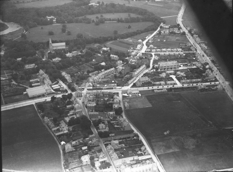
Ferryhill
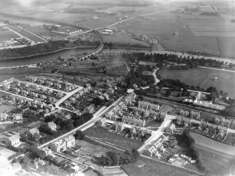
Ferryhill looks quite rural with Duthie Park on the right, the River Dee to the north and open fields beyond in this below photograph from the 1930s.
The Caledonian Railway is carried over the Dee on a handsome viaduct, while the extensive sidings and railway buildings can be seen on the south bank.
Ferryhill itself used to comprise of large villas and grounds like the Devanha House, Ferryhill House and Arthurseat House.
But in the early 19th Century a formal street plan was laid out to establish what is now thought of as one of the city’s most historic suburbs.
Polmuir Road stretches up the middle of the foreground, intersected by Deemount Road on the left and Brunswick Place on the right.
Further expansion saw the land to the bottom right built over during the 20th Century.
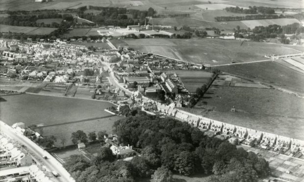
Cults
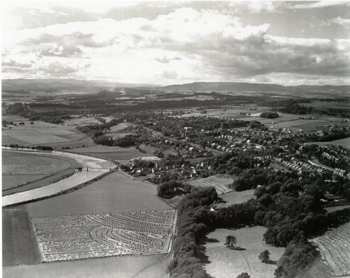
In this 1948 bird’s eye view photograph of Cults, below, local landmark St Devenick’s Bridge, better known as the ‘Shakkin’ Briggie’, is still intact.
These days it is a derelict and rusty relic of the past that overhangs the River Dee.
The straight line cutting through the houses in the middle of the photograph is the Deeside section of the Great North of Scotland Railway.
The Deeside line carried passengers from the city to Ballater, stopping at Cults Station which is hidden by a copse of trees in the snap below.
Although the community of Cults has changed little from above, one change that is very absent here in 1948 is the vast reservoir.
The fields in the bottom left corner are now home to the giant Inchgarth reservoir and beauty spot.
Footdee
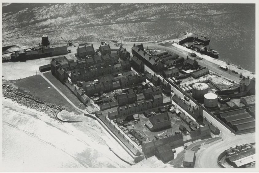
This photo from 1966 unmistakably shows the coastal community of Footdee, known to Aberdonians as “Fittie”.
The well-known grid layout of historic fishing village Fittie is particularly obvious in this aerial photo, below.
Sitting by the mouth of Aberdeen Harbour and Porca Quay, the site of the charming cottages and narrow lanes originally dates to mediaeval times.
But the square, uniform plan of housing we are familiar with today was devised in the 1800s for the city’s fishing families.
The houses were designed to have their backs to the harsh North Sea and a close-knit community existed within.
The rows of houses on the left of the photo are Pilot’s Square, South Square and North Square.
They look the same from above today, but closer up the cute cottages feature a myriad of colours and trinkets, surely making it Aberdeen’s most quirky community.
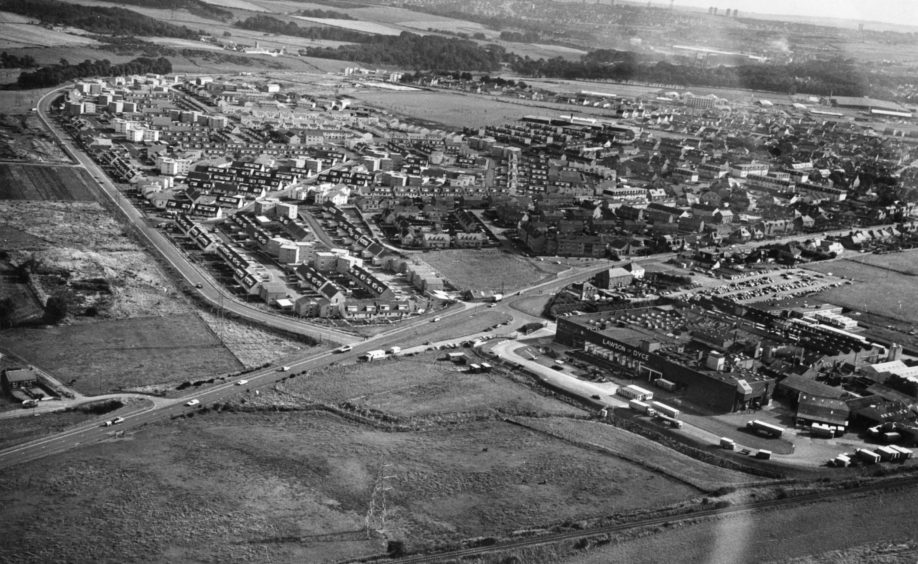
Dyce
Even in this below photo of Dyce from 1975, the community had changed remarkably from the early 20th Century when it was a village and parish in its own right.
The historic Victoria Street cuts through this photo left to right, once surrounded by fields, it was encircled by houses by the 1970s.
Once a big employer in the area, meat processor Lawson of Dyce sits by the River Don at the bottom right.
The firm’s bacon-curing operations ended in 1979 with the loss of 600 jobs before the entire factory closed in 1986.
On the left, the new housing of Riverside Drive sweeps all the way around towards the airport which is just out of shot on the right.
And on the horizon you can see the tower blocks of Aberdeen and how much the city encroached towards, and engulfed, a once rural community.