Do you live in Bankhead or Bucksburn? Hilton or Woodside? Balnagask or Torry?
Well, now the debate can be put to bed… sort of.
An online interactive map shows the boundaries of all 37 official “neighbourhoods” of Aberdeen.
The neighbourhoods, which have had the same boundaries since approximately 2009, are used by Aberdeen City Council for statistics relating to population, households, occupancy, travel to work and economic activity.
All of Aberdeen City’s 185.6sq. km – which is bigger than Glasgow City’s boundaries – are included.
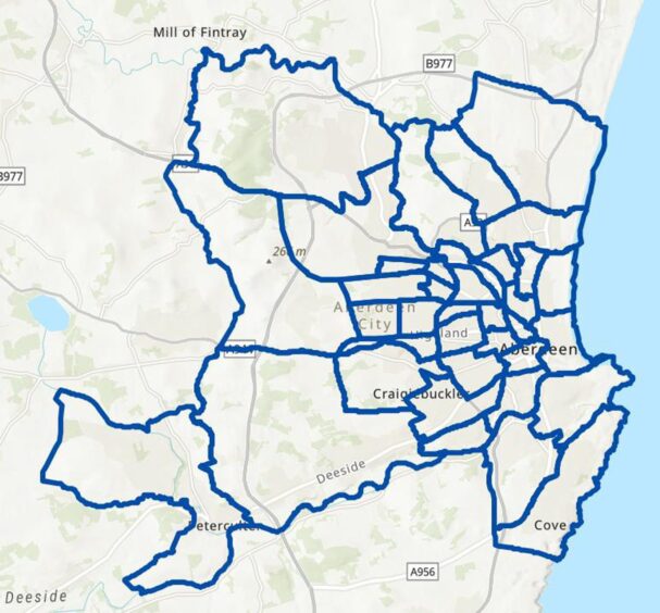
Click here to see interactive map of Aberdeen’s neighbourhoods
In the map, people can zoom in to see exactly where their street lies, with boundaries marked by blue lines.
The neighbourhoods are separate from the 30 community council areas of Aberdeen, as well as the 13 electoral wards used to elect city councillors at local elections.
For the past 15 years, boundaries have remained the same – and although the change is not shown on the map – Cults, Bieldside and Milltimber has since been renamed to include Countesswells.
The Danestone question
The names and boundaries used are sure to cause some tension to locals, who feel that their area should be a neighbourhood in its own right, or at least have its name included in one.
For example, due to Bridge of Don’s large population – estimated at more than 23,300 – it is split into four neighbourhoods: Balgownie and Donmouth, Danestone, Denmore and Oldmachar.
However, even classing Danestone as part of Bridge of Don can be contentious in some quarters north of the River Don.
A well-known area that is not included on its own or named at all is Kittybrewster, which is split between Hilton and Woodside respectively
The historic fishing village of Footdee is also not given name recognition and is part of Hanover, which includes the beach and harbour, as well as part of King Street and surrounding streets typically associated with the centre of the city.
In terms of central Aberdeen, the city centre is a neighbourhood in its own right, as is George Street.
Some other areas have expanded into “new territory” including Cove, which takes in most of Altens and some of Kincorth Hill Nature Reserve.
Another area that has expanded when comparing these boundaries to more traditional ones is Hazlehead, which also includes Hill of Rubislaw, Rubislaw Quarry and Woodend Hospital.
Of course, not all areas can be included and 37 seems like an appropriate number to split up Aberdeen’s estimated population of 227,430, especially when considering the urban population within the city limits.
Varying populations
Population varies between each of the neighbourhoods, with 2019 estimates showing that Braeside, Mannofield, Broomhill and Seafield – which takes up a large chunk of the West End – was the most populated with 13,535 residents.
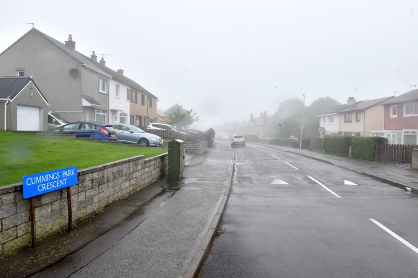
The smallest, Cummings Park – which is where Northfield Academy is located – had just 1,812 living there in 2019.
To divide things even further, the neighbourhoods are divided into geographical “localities” by Community Planning Aberdeen in order to “plan for and deliver improved outcomes”.
They are divided into North (N), Central (C) and South (S), with each neighbourhood having a specific code – made up of locality and number.
List of neighbourhoods
North
N1 Dyce; N2 Danestone; N3 Oldmachar; N4 Denmore; N5 Balgownie and Donmouth; N6 Bucksburn; N7 Heathryfold; N8 Middlefield; N9 Kingswells; N10 Northfield; N11 Cummings Park; N12 Sheddocksley; N13 Mastrick; N14 Summerhill
Central
C1 Tillydrone; C2 Old Aberdeen; C3 Seaton; C4 Woodside; C5 Hilton; C6 Stockethill; C7 Ashgrove; C8 George Street; C9 Froghall, Powis and Sunnybank; C10 Midstocket; C11 Rosemount; C12 City Centre; C13 Hanover; C14 West End
South
S1 Culter; S2 Cults, Bieldside, Milltimber and Countesswells; S3 Hazlehead; S4 Braeside, Mannofield, Broomhill and Seafield; S5 Garthdee; S6 Ferryhill; S7 Kincorth, Leggart and Nigg; S8 Torry; S9 Cove
Despite there being 37 official neighbourhoods across the city, there is no official answer to what constitutes an area and everybody’s interpretations will be different.
Let us know your thoughts on the neighbourhoods in the comments section below. Do you think they reflect the geography of Aberdeen and does your area make the cut?


Conversation