Calendar An icon of a desk calendar. Cancel An icon of a circle with a diagonal line across. Caret An icon of a block arrow pointing to the right. Email An icon of a paper envelope. Facebook An icon of the Facebook "f" mark. Google An icon of the Google "G" mark. Linked In An icon of the Linked In "in" mark. Logout An icon representing logout. Profile An icon that resembles human head and shoulders. Telephone An icon of a traditional telephone receiver. Tick An icon of a tick mark. Is Public An icon of a human eye and eyelashes. Is Not Public An icon of a human eye and eyelashes with a diagonal line through it. Pause Icon A two-lined pause icon for stopping interactions. Quote Mark A opening quote mark. Quote Mark A closing quote mark. Arrow An icon of an arrow. Folder An icon of a paper folder. Breaking An icon of an exclamation mark on a circular background. Camera An icon of a digital camera. Caret An icon of a caret arrow. Clock An icon of a clock face. Close An icon of the an X shape. Close Icon An icon used to represent where to interact to collapse or dismiss a component Comment An icon of a speech bubble. Comments An icon of a speech bubble, denoting user comments. Comments An icon of a speech bubble, denoting user comments. Ellipsis An icon of 3 horizontal dots. Envelope An icon of a paper envelope. Facebook An icon of a facebook f logo. Camera An icon of a digital camera. Home An icon of a house. Instagram An icon of the Instagram logo. LinkedIn An icon of the LinkedIn logo. Magnifying Glass An icon of a magnifying glass. Search Icon A magnifying glass icon that is used to represent the function of searching. Menu An icon of 3 horizontal lines. Hamburger Menu Icon An icon used to represent a collapsed menu. Next An icon of an arrow pointing to the right. Notice An explanation mark centred inside a circle. Previous An icon of an arrow pointing to the left. Rating An icon of a star. Tag An icon of a tag. Twitter An icon of the Twitter logo. Video Camera An icon of a video camera shape. Speech Bubble Icon A icon displaying a speech bubble WhatsApp An icon of the WhatsApp logo. Information An icon of an information logo. Plus A mathematical 'plus' symbol. Duration An icon indicating Time. Success Tick An icon of a green tick. Success Tick Timeout An icon of a greyed out success tick. Loading Spinner An icon of a loading spinner. Facebook Messenger An icon of the facebook messenger app logo. Facebook An icon of a facebook f logo. Facebook Messenger An icon of the Twitter app logo. LinkedIn An icon of the LinkedIn logo. WhatsApp Messenger An icon of the Whatsapp messenger app logo. Email An icon of an mail envelope. Copy link A decentered black square over a white square.

Red ‘danger to life’ warning EXTENDED as new alerts issued across Highlands and Aberdeenshire

The Met Office has extended the red alert for rain affecting Montrose, Laurencekirk, Brechin and Inverbervie - and issued three new alerts for severe weather across the north and north-east.

Huge waves at Stonehaven harbour during Storm Babet.
Huge waves in the background in Stonehaven as a dog walker takes their pooches for a windy stroll. Image: Darrell Benns/DC Thomson.

Residents across the north and north-east have been warned to expect more severe weather and further disruption tomorrow.

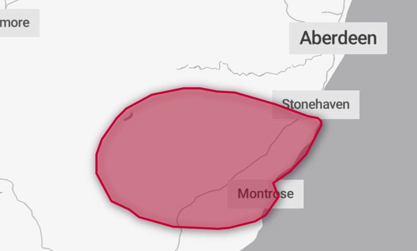
The red “danger to life” warning, which covers Montrose, Laurencekirk, Brechin and Inverbervie, has been extended until 11.59pm on Saturday.

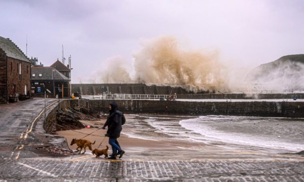
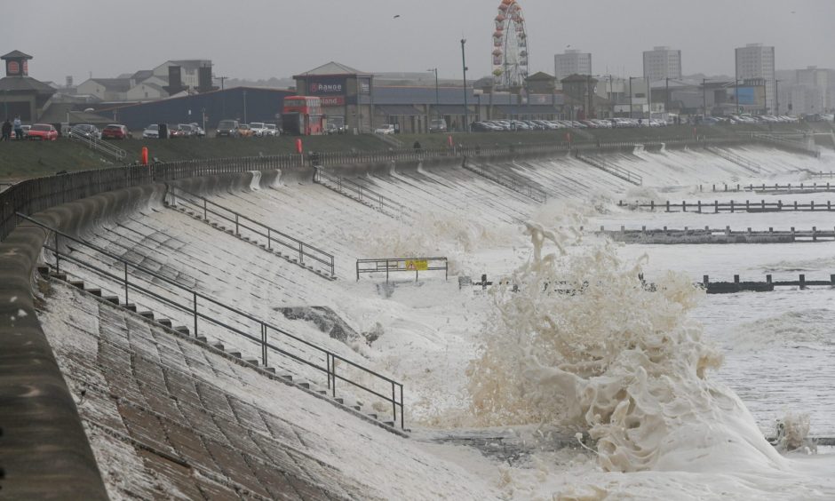
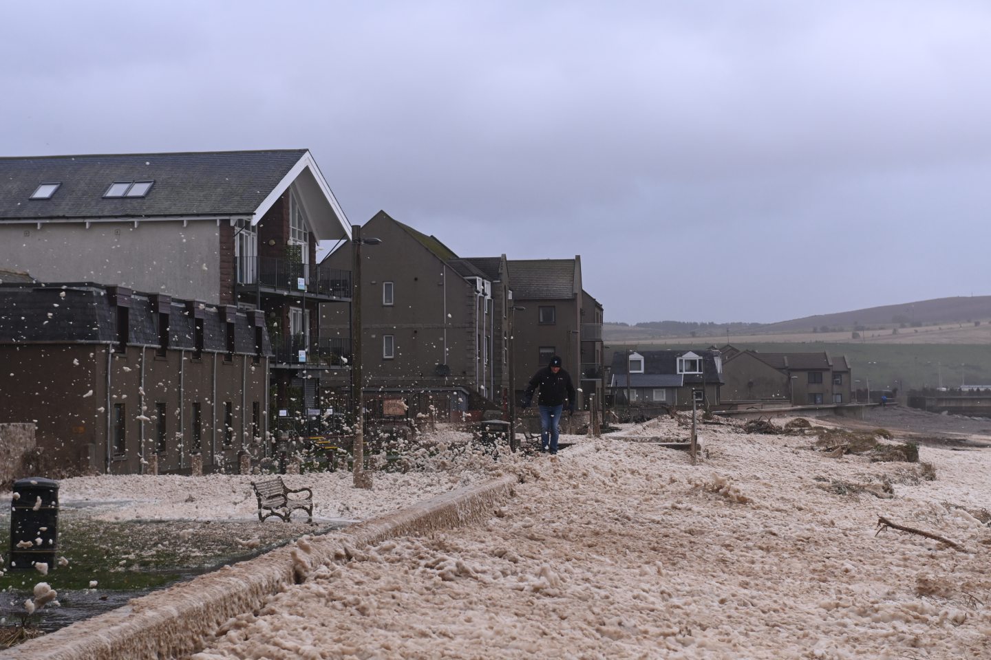
Storm Babet has been ripping through most parts of the country since Thursday, causing chaos to travel and services.

Two people have fallen victims to the storm’s fury, while a search is ongoing for a man believed to have been trapped in a vehicle near Marykirk.

Map showing area across Aberdeenshire that the Met Office has extended the red warning for during Storm Babet.
Red warning in Aberdeenshire caused by Storm Babet has been extended until Sunday. Image: Met Office.

A 56-year-old man has died after the van he was driving was hit by a tree near Forfar.

The body of a 57-year-old woman from Angus was also recovered from the River South Esk on Thursday.

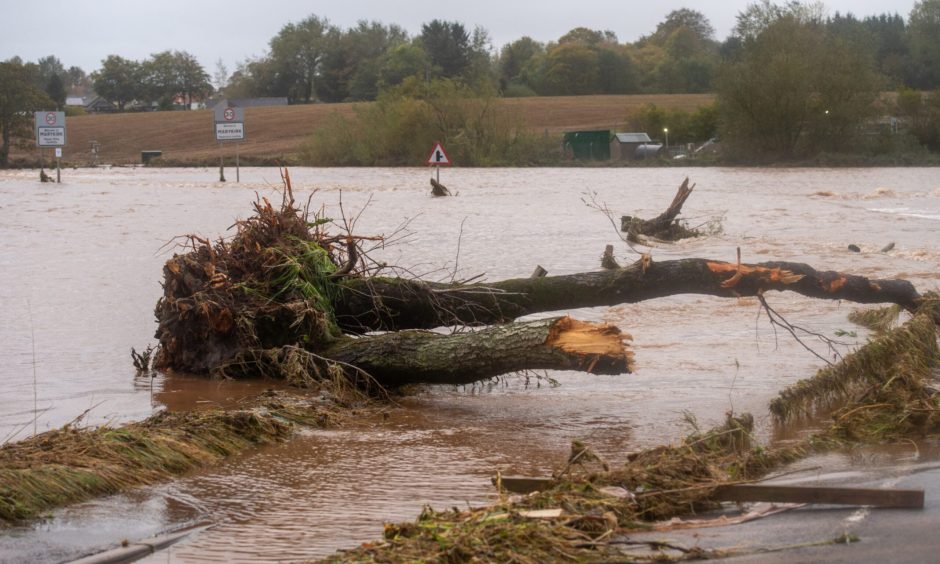
Roads and households across the north and north-east have been left underwater after torrential rain and high winds hit the region.

And forecasters predict more is about to come, with around 70-100mm of rain expected to fall within the next 18 to 24 hours.

Stormy waves crashing into Aberdeen beach. Image: Kenny Elrick/DC Thomson.

New alerts for rain and wind issued for Aberdeen and Aberdeenshire

The Met Office has issued several more weather alerts for the north and north-east, as residents still attempt to recover from yesterday’s harsh conditions.

A yellow alert for rain will be in force for Aberdeen, Aberdeenshire and Moray until 11.59pm tomorrow.

This is alongside a yellow alert for wind, which will be in place until noon.

A map of weather warnings across Aberdeen and Aberdeenshire during Storm Babet.
The Met Office’s map shows the main areas, affected by Storm Babet. Image: Met Office.

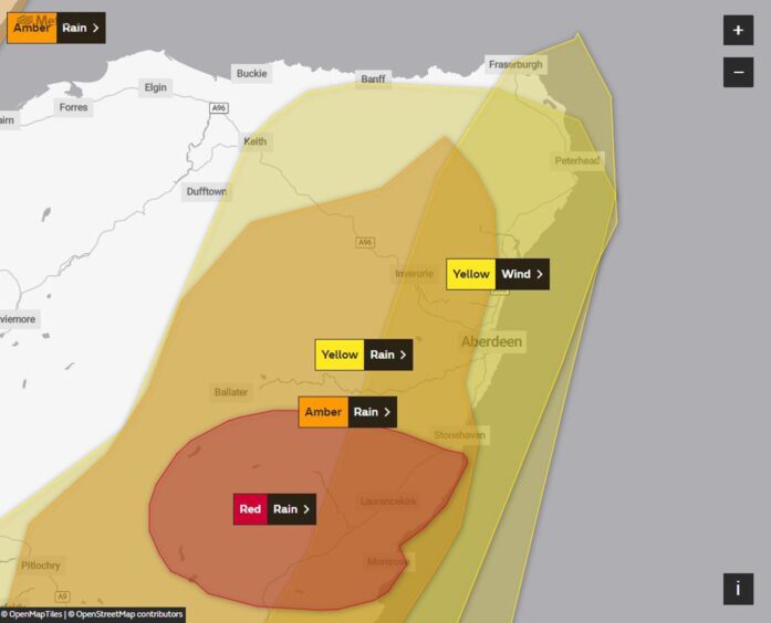
The worst of the weather will hit western and southern Aberdeenshire, with residents warned to expect “heavy and prolonged” rainfall throughout Saturday.

The area affected by this stretches out to Banchory, Aboyne and Ballater in Deeside, as well as Alford and Inverurie in Donside.

There is an additional amber warning for rain for these parts, which will be into effect from midnight until 11.59pm on Saturday.

Picture shows sea foam flying about Stonehaven following day one of Storm Babet.
Sea foam has covered the coastline in Stonehaven amid high winds. Image: Darrell Benns/DC Thomson.

Met Office chief meteorologist Andy Page said: “This is not usual autumn weather.

“This is an exceptional event, and we are likely to continue to see significant impacts with the potential for further flooding and damage to properties.”

He added: “We have issued a second red warning covering parts of Angus and Aberdeenshire.

“This has the potential to cause further impacts in this already hard-hit area.”

Parts of the A937 road near Marykirk, Aberdeenshire, have collapsed while large sections of the road have been flooded. Image: Kath Flannery/DC Thomson.

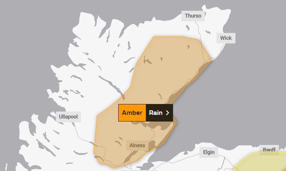
Amber warning issued for the Highlands amid Storm Babet

Meanwhile, a new amber alert for rain has been issued for some parts of the Highlands.

This will be in place until Sunday.

Several towns north of Inverness are affected by the latest warning – including Dingwall, Alness, Dornoch, Golspie, Tain, Brora and Bonar Bridge.

A map showing amber weather warning for parts of the Highlands during Storm Babet.
The amber alert follows two days of severe weather in the north and north-east. Image: Met Office.

What to expect amid Met Office’s new weather warnings?

The Met office is urging residents to take extra caution in the next 48 hours as Storm Babet continues to rage on across the north and north-east.

Most parts of Aberdeen and Aberdeenshire are still at risk of extensive flooding to homes and businesses amid the “danger to life” warning.

Thousands of homes have been left in the dark since yesterday, and experts predict there could be further disruption to power, water and heating supplies.

Public transport is also likely to be affected, while there is a serious risk some buildings could be damaged.

Storm Babet live updates: A90 closed as torrential rain causes heavy flooding across north and north-east

Conversation