Calendar An icon of a desk calendar. Cancel An icon of a circle with a diagonal line across. Caret An icon of a block arrow pointing to the right. Email An icon of a paper envelope. Facebook An icon of the Facebook "f" mark. Google An icon of the Google "G" mark. Linked In An icon of the Linked In "in" mark. Logout An icon representing logout. Profile An icon that resembles human head and shoulders. Telephone An icon of a traditional telephone receiver. Tick An icon of a tick mark. Is Public An icon of a human eye and eyelashes. Is Not Public An icon of a human eye and eyelashes with a diagonal line through it. Pause Icon A two-lined pause icon for stopping interactions. Quote Mark A opening quote mark. Quote Mark A closing quote mark. Arrow An icon of an arrow. Folder An icon of a paper folder. Breaking An icon of an exclamation mark on a circular background. Camera An icon of a digital camera. Caret An icon of a caret arrow. Clock An icon of a clock face. Close An icon of the an X shape. Close Icon An icon used to represent where to interact to collapse or dismiss a component Comment An icon of a speech bubble. Comments An icon of a speech bubble, denoting user comments. Comments An icon of a speech bubble, denoting user comments. Ellipsis An icon of 3 horizontal dots. Envelope An icon of a paper envelope. Facebook An icon of a facebook f logo. Camera An icon of a digital camera. Home An icon of a house. Instagram An icon of the Instagram logo. LinkedIn An icon of the LinkedIn logo. Magnifying Glass An icon of a magnifying glass. Search Icon A magnifying glass icon that is used to represent the function of searching. Menu An icon of 3 horizontal lines. Hamburger Menu Icon An icon used to represent a collapsed menu. Next An icon of an arrow pointing to the right. Notice An explanation mark centred inside a circle. Previous An icon of an arrow pointing to the left. Rating An icon of a star. Tag An icon of a tag. Twitter An icon of the Twitter logo. Video Camera An icon of a video camera shape. Speech Bubble Icon A icon displaying a speech bubble WhatsApp An icon of the WhatsApp logo. Information An icon of an information logo. Plus A mathematical 'plus' symbol. Duration An icon indicating Time. Success Tick An icon of a green tick. Success Tick Timeout An icon of a greyed out success tick. Loading Spinner An icon of a loading spinner. Facebook Messenger An icon of the facebook messenger app logo. Facebook An icon of a facebook f logo. Facebook Messenger An icon of the Twitter app logo. LinkedIn An icon of the LinkedIn logo. WhatsApp Messenger An icon of the Whatsapp messenger app logo. Email An icon of an mail envelope. Copy link A decentered black square over a white square.

Will you see thundersnow this week? Here’s what forecasters are predicting for Scotland

Forecasters have warned of continued snowfall later today and tomorrow for areas across the north of Scotland.

Commuters in the Highlands have already seen snowy conditions and icy roads this morning, leading to a number of crashes on north routes.

The Met Office has warned that strong winds of up to 60 mph should be expected this evening along with wintry showers, ice, hail and lightning.

They say 10-20 cm of snow could fall, with blizzard conditions expected away from the western coasts.

A flood alert has been issued for Aberdeenshire and Aberdeen City ahead of expected high tides and storm rainfall.

Road and rail services may also be affected with delays and cancellations possible.

The Met Office’s Chief Forecaster said: “The stream of very cold air will continue to affect much of Britain, bringing a mixture of hazards.

“Amounts of snow will be very variable, and snow could turn back to sleet or rain for a time during the day in some areas.”

capture

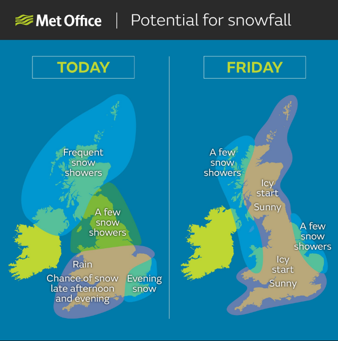
Moving into tomorrow, forecasters expect cold northerly winds to bring a further area of heavy snow across the northern isles and north-east, along with gusts of 70mph.

A further 2-5 cm of snow is likely away from immediate exposed coasts, with a further 10-20 cm possible in areas above around 200 m.

Severe blizzard conditions are likely on high ground, with drifting of the snow.

c194zcbwiaexb-c

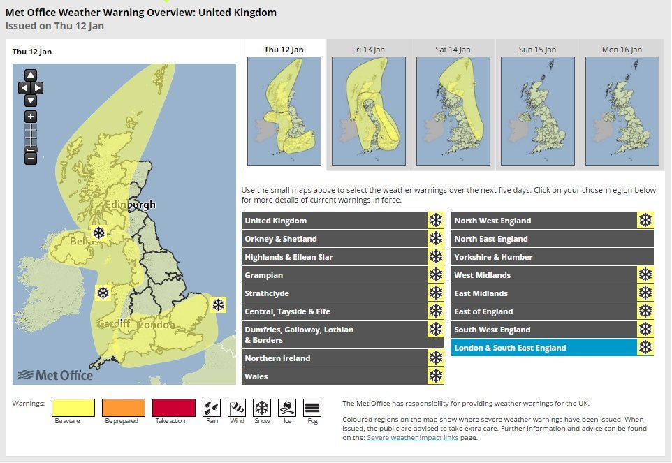
Further significant disruption to transport networks seems likely, along with possible disruption to power supplies, although not all areas will be equally affected.

The worst of the conditions should ease overnight across the Northern Isles and during Friday morning elsewhere.

On Saturday, showers of sleet and snow will continue. Further accumulations of 2 to 4 cm of snow may affect lowland areas while high ground may see locally 5 to 10 cm.

Ice will be an additional hazard on untreated surfaces and disruptions to transport networks is likely.