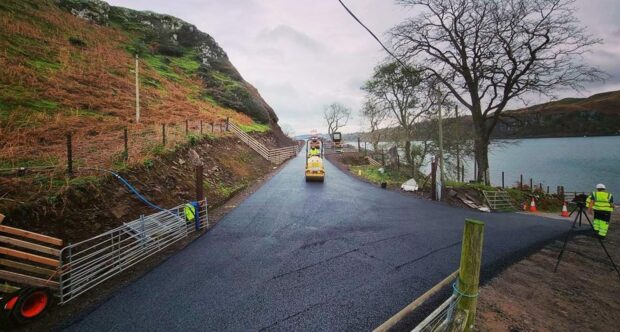
Islanders are celebrating after a tarmac road has finally linked up one end of the island with the other.
Kerrera, a wildlife mecca that sits proudly in Oban Bay sheltering the town from the worst of the west coast winds, has long wanted a road to link the north of the island with the south.
This week, after years of delay the road was finally finished.
With the road, everyone on the island has access to the lifeline ferry service to the south of the island.
More than a year to get the road tarmacked
Until now, “Northenders” could take a small private passenger ferry from Oban’s North Pier, if it was running. Or struggle over tracks or use a quad, or horse from the south.
The road’s path was finished a year ago, and islanders walked from one end to the other. But it has taken until now for the road to be finished with tarmac.
The Isle of Kerrera Development Trust (IKDT) project managed the road, islander Martin Shields was the project manager.
He said: “We are still honestly pinching ourselves. It is so hard to convey to people just how much of a difference it will make to the future of the island.
“We can now be part of a whole community with the people who live on the other half of the island. Kerrera is a booming population and we have gone from half a population, half an island to a place where we can all meet.
“We can now even go out for food or for a pint on the mainland and get home.”
‘Never thought it would happen’
He continued: “The development trust had three things on its wishlist – to own the old school, to bring that school into use as the first public building on the island, and to have a north to south road.
“If I am honest we thought it might never happen.”
The community had to organise and project manage the building of the road themselves, with Crown Estate and Scottish Government money.
Mr Shields said: “It was a lot of work for people, but it is something that makes you feel so much better.
“We are delighted – this ensures all residents can access the lifeline ferry.”
The community on Kerrera had been trying for more than 30 years to connect the north end of Kerrera to the south.
Argyll and Bute Council, working with the community invested £200,000 as part of its share of Crown Estates funding, to help the community finish the works by tarmacking the road. The Scottish Government also helped.
Councillor Robin Currie, leader of Argyll and Bute Council said: “This is an enormous achievement for the Kerrera community who have worked tirelessly to raise funding for the new road.

“I would like to congratulate everyone involved in this important project that will now make day-to-day island life easier and help support the local economy.”
What are the roads like on the island?
Before this week, anyone wishing to go from the north end of the island to the south had little choice, but to walk or go by ferry to Oban and walk to the ferry terminal at Gallanach.
There is a road of sorts around the south of the island. Quarter of a mile of that council-adopted road was recently re-tarmacked.
It still has many gates and potholes, and winds round to the west side of the island – to Gylen Castle and an excellent teashop.
While the road is dodgy at parts to the teashop, it is non-existent afterwards.
In fact, at one point, the road on the westside is so bad a warning is given about using bikes on it.


Conversation