Underwater imaging experts are trialling the use of a first-of-its-kind system that could see 3D digital models used by Scottish seafood producers to map out and monitor complex marine environments and habitats.
Oban-based diving and underwater research company Tritonia Scientific is leading the project.
Partners include the Lyell Centre at Heriot-Watt University, seafood producer Mowi, and the Stirling University-based Sustainable Aquaculture Innovation Centre (SAIC).
The aim is to test the effectiveness of using remotely operated vehicles (ROVs) to create digital twins of the seabed.
Over the next 12 months, the team at Tritonia, building on existing environmental data, will develop a digital record of hard seabed at selected Mowi sites using a technique known as georeferenced photogrammetry.
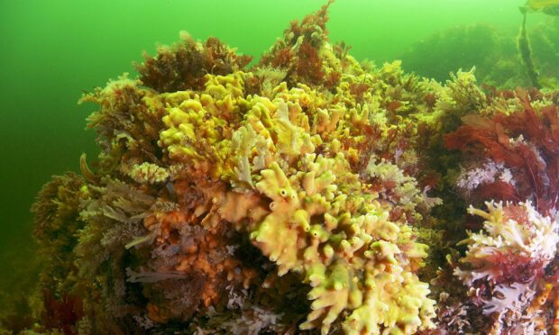
Compared to soft seabed, where sediment samples can be taken regularly and easily, monitoring hard substrates can be challenging because of the low visibility of the water.
The hard nature of the seabed also makes it almost impossible to grab samples.
Tech could help decide where future fish farms should be located
Tritonia will use underwater ROVs linked to above water GPS technology and acoustic transponders to capture digital images of the seabed to assess current and future finfish farms.
The project will also identify the presence of priority marine features – nationally protected habitats and essential underwater ecosystems for Scotland’s coastal seas.
Using the images, Tritonia will create an accurate 3D model that can show various physical characteristics and be used alongside advanced comparison software to monitor changes on the seabed.

Tritonia already employs 3D photogrammetry to survey and monitor marine renewable installations, piers and harbours, and to inform decommissioning programmes in the oil and gas sector.
The firm’s latest project represents its first breakthrough into aquaculture.
It is believed the technology may present significant opportunities for companies in the sector to obtain accurate, digital records of the seabed close to their operations.
Sustainability goal
Tritonia managing director Martin Sayer said: “Using imaging technology could help the aquaculture sector to gain a much more detailed, accurate picture of the complex seabeds they are operating beside or above.
“Our hope is that the system could, ultimately, support regulation and environmental monitoring in ways that would provide the levels of evidence that would be necessary for future sustainable operations.
ICYMI: #LyellCentre scientist @HLBurdett is supporting @TritoniaDiving in testing underwater ROVs to conduct 3D mapping of #marine habitats. The #photogrammetry will improve understanding of the #seabed and #aquaculture. https://t.co/yjRuQWnkk4@HeriotWattUni @BritGeoSurvey
— Lyell Centre (@LyellCentre) August 17, 2022
“At the moment, divers face a range of challenges in terms of visibility and climate, particularly if algal blooms are present, but the digital twin allows us to essentially remove the surrounding water at the click of a button, using images captured by an ROV.
“Just one survey can generate a 3D model that provides a permanent record of the seabed terrain at a fixed point in time, which could be used for comparisons for years to come.”
Our hope is that the system could, ultimately, support regulation and environmental monitoring in ways that would provide the levels of evidence that would be necessary for future sustainable operations.”
Martin Sayer, managing director, Tritonia Scientific.
According to SAIC, a single ROV dive could deliver a wealth of data and images to provide aquaculture firms with accurate information to aid decision-making, such as the volume and area of specific geographical features.
The technology could also be used to detect protected habitats such as maerl beds, an important but fragile form of natural carbon storage.
While difficult to map, maerl beds are an important consideration for decisions about potential fish farm locations.
Real-world applications
SAIC chief executive Heather Jones said: “Technology is becoming increasingly important for the aquaculture sector and collaborative research projects and trials can be an incredibly valuable demonstration of the real-world applications of new data-led techniques.
“In this case, we could see ROVs and imaging technology playing a vital role in monitoring the sector’s environmental impact – and increasing its economic impact by supporting future decisions about farm locations and possible expansion.”


Conversation