
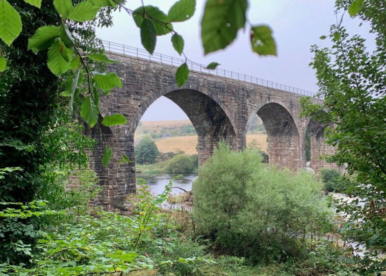
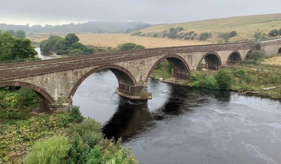
North Water Viaduct, Montrose, Angus
The Victorian viaduct which spans the River North Esk is such an iconic sight to travellers on the A92 that it is hard to imagine what the landscape would look like without it.
Yet in 1986, British Rail applied for permission to demolish the 11-arch structure which had carried trains on the Montrose to Inverbervie branch line for more than 100 years since its opening in 1865.
The line was closed in 1966, but thankfully the bid to bring it down was refused and subsequently the viaduct was refurbished and now forms part of the National Cycle Network.
It is also a fine centre-point for an interesting and varied walking loop from Montrose which involves beach, riverside and woodland sections, before returning via the cycle path and other variations.
I started from the Links where there is ample parking and facilities, but for those arriving by bus or train it’s only a short walk from the centre of town. The walk is well-signed (there is a handy guide to the full Montrose path network on the Angus Council website).
The first five kilometres were north along the wide sands beneath the huge dunes. Check the tide times before you set off – at high water some sections may be impassable.
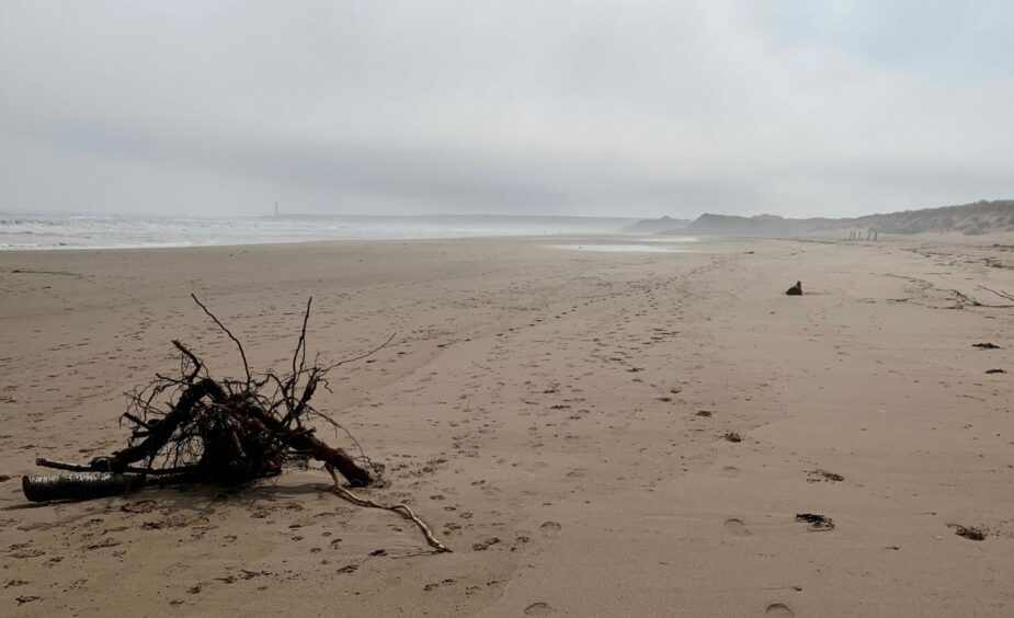
The haar was still clinging to the coastline when I set off along the empty beach. With the sun’s efforts to break through sparking a strange luminescence, coupled with the rhythmic crashing of the water it created a slightly eerie, even otherworldly, feel. I could just make out the Scurdie Ness lighthouse, and a flash of rusty of red from a distant container ship.
The beach was strewn with the detritus left by the retreating sea. There was the usual weird artwork of trees and seaweed, and jellyfish of all shapes and sizes. Sadly, there were also the remains and intact bodies of birds, an all too familiar occurrence during the current avian flu outbreak.
As I neared the river, there were several options to head left through the dunes, but I stayed the course to the end to see the huge colonies of birds camped on the temporary islands in the river. It was simple to then turn sharply back on a sandy path and join a grassy track running west.
I passed a few old concrete defence posts to reach a junction where a signpost presented the options. Sticking by the river, the next turn came when the track started to swing left. I went right, following a narrow and somewhat neglected path into woodland (there is a faded signpost buried in the undergrowth) alongside a burn.
The few fallen trees across the path were easy to negotiate, before I walked out under the massive stone arches of the viaduct and on to the road. Almost immediately, a set of steps on the left goes uphill back into the woods.
A right turn along the cycle path starts the return journey, but it’s worth first turning left and wandering over the viaduct for a bird’s eye view of the landscape.

The walk back was fast on a good surface, with just a few twists and turns. Beyond the turn approaching the sewage works, I left the cycle path and went straight ahead on a grassier path, the sounds of the crashing waves becoming clearer again.
The final section was on tracks along the edge, and then through, the golf course before it swung right to make an exit to Traill Drive for the last stretch round to the starting point.
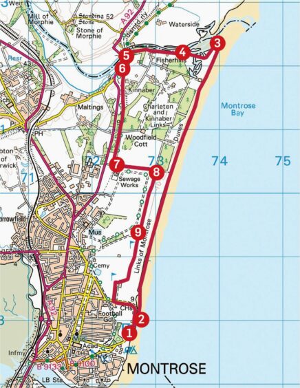
ROUTE
1. From promenade, go down steps opposite Pavilion to beach.
2. Turn left and walk along wide sands for almost 5km towards River North Esk.
3. Turn sharp left and take sandy path through dunes to join grass track, then follow round to right, crossing small bridge and passing old concrete defence barriers.
4. At Montrose Path Network signpost (green) keep right alongside water. Pass house and when track starts to swing left uphill, turn right to pick up path that follows burn through woodland (faded signpost in undergrowth) to reach North Water Viaduct.
5. Pass under viaduct to emerge on road, then immediately climb steps to left (signed).
6. Turn right on to cycle path at top of steps. This runs parallel with road at first, but shortly after crossing entrance track to Kinnaber it swings through woods to emerge at car park. Go straight ahead on track again to reach another junction before sewage works.
7. Go left as signed, then when track curves right go straight ahead on grass path through gorse and follow to fence junction.
8. Turn right along fence (do not cross stile) on grass track, then take any of the pedestrian gates on left to access track along edge of golf course.
9. Keep straight ahead through golf course over few crossroads until track swings right towards buildings. Pass through then walk down past houses to road junction.
10. Turn left along road (Traill Drive) and follow back to seafront parking.
INFORMATION
Distance: 12km/7.5miles
Ascent: 50m/165ft
Time: 3-4 hours
Grading: Varied and well-signed circuit suitable for all ages and abilities through beach, riverside and woodland terrain, although may be too long for younger children. Check tide times: at high water some parts of beach route may prove inaccessible. Can be muddy in places, good footwear advised.
Start/finish: Montrose Links parking (Grid ref: NO 726578).
Map: Ordnance Survey 1:50,000 Landranger Maps 54 (Dundee & Montrose) and 45 (Stonehaven & Banchory); Ordnance Survey 1:25,000 Explorer sheet 382.
Tourist Information: Tourist Information: VisitScotland, Dundee iCentre, 16 City Square, Dundee, DD1 3BG (Tel 01382 527527).
Public transport: Regular bus (X7) and train services to Montrose between Dundee and Aberdeen.
Conversation