Calendar An icon of a desk calendar. Cancel An icon of a circle with a diagonal line across. Caret An icon of a block arrow pointing to the right. Email An icon of a paper envelope. Facebook An icon of the Facebook "f" mark. Google An icon of the Google "G" mark. Linked In An icon of the Linked In "in" mark. Logout An icon representing logout. Profile An icon that resembles human head and shoulders. Telephone An icon of a traditional telephone receiver. Tick An icon of a tick mark. Is Public An icon of a human eye and eyelashes. Is Not Public An icon of a human eye and eyelashes with a diagonal line through it. Pause Icon A two-lined pause icon for stopping interactions. Quote Mark A opening quote mark. Quote Mark A closing quote mark. Arrow An icon of an arrow. Folder An icon of a paper folder. Breaking An icon of an exclamation mark on a circular background. Camera An icon of a digital camera. Caret An icon of a caret arrow. Clock An icon of a clock face. Close An icon of the an X shape. Close Icon An icon used to represent where to interact to collapse or dismiss a component Comment An icon of a speech bubble. Comments An icon of a speech bubble, denoting user comments. Comments An icon of a speech bubble, denoting user comments. Ellipsis An icon of 3 horizontal dots. Envelope An icon of a paper envelope. Facebook An icon of a facebook f logo. Camera An icon of a digital camera. Home An icon of a house. Instagram An icon of the Instagram logo. LinkedIn An icon of the LinkedIn logo. Magnifying Glass An icon of a magnifying glass. Search Icon A magnifying glass icon that is used to represent the function of searching. Menu An icon of 3 horizontal lines. Hamburger Menu Icon An icon used to represent a collapsed menu. Next An icon of an arrow pointing to the right. Notice An explanation mark centred inside a circle. Previous An icon of an arrow pointing to the left. Rating An icon of a star. Tag An icon of a tag. Twitter An icon of the Twitter logo. Video Camera An icon of a video camera shape. Speech Bubble Icon A icon displaying a speech bubble WhatsApp An icon of the WhatsApp logo. Information An icon of an information logo. Plus A mathematical 'plus' symbol. Duration An icon indicating Time. Success Tick An icon of a green tick. Success Tick Timeout An icon of a greyed out success tick. Loading Spinner An icon of a loading spinner. Facebook Messenger An icon of the facebook messenger app logo. Facebook An icon of a facebook f logo. Facebook Messenger An icon of the Twitter app logo. LinkedIn An icon of the LinkedIn logo. WhatsApp Messenger An icon of the Whatsapp messenger app logo. Email An icon of an mail envelope. Copy link A decentered black square over a white square.

Storm Eunice: Brace yourself as Met Office issues TWO more weather warnings

Met Office issues two more weather warnings for ice, heavy rain and wind.

There is no end in sight to severe winter weather as strong winds, heavy rain and ice are set to continue over the weekend amidst plummeting temperatures across Aberdeenshire, Moray, the Highlands and islands following Storm Eunice.

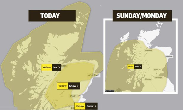
The Met Office has issued two more yellow weather warnings for the north, north-east and islands across the weekend and into Monday.

The first weather warning is in place from 6pm on Friday, until Saturday at 9am. The yellow weather warning is for icy conditions.

With forecasters predicting overnight lows of -3C in Stornoway, and in -2C in Aviemore – temperatures in many places will not get above zero on Saturday.

Due to wind chill factor, during the day temperatures will feel more like -4C in places. So wrap up well.

Tonight and into Saturday people have been told to be cautious when out walking, cycling or driving.

The warning is in place for the whole of the Highlands, Moray, Grampian, Argyll, the Western Isles and Orkney.

A Met Office spokesman said: “A mixture of wintry showers and clear spells are likely to lead to a cold night with some icy stretches developing on untreated surfaces.”

A warning for poor visibility is in place for the entire weekend and into Monday.

Bad weather is set to continue into Monday

Strong winds are forecast. Picture by Chris Sumner

The bad weather is due to continue with another weather warning in place for Sunday into Monday.

Forecasters say that from Sunday at noon strong winds are expected across parts of the west coast and islands, and for most of the Highlands.

Winds of up to 43mph are being predicted in the Western Isles on Sunday from 8pm. In Oban wind speeds of up to 50mph are expected, and due to wind chill it will feel like -2C.

Due to the strong winds, the Met Office has told people to expect damage to buildings, including tiles being blown from roofs,

The spokesman continued: “There is a small chance that injuries and danger to life could occur from large waves and beach material being thrown onto sea fronts, coastal roads and properties.

“There is a small chance of longer journey times or cancellations as road, rail, air and ferry services are affected.”

The weather warning is in place  until 12noon on Monday.

Storm Eunice is battering the north today, with the AWPR closed as lorries jackknife in heavy snow.