Strong winds and rain are forecast to howl across the north and north-east as Met Office issues two yellow weather warnings.
Last week brought wet and windy weather as the winter months begin to close in and temperatures start to drop – a trend that is forecast to continue.
Those living along the west coast in places including Fort William and Oban should prepare for more rain on Tuesday as the Met Office has issued a yellow warning covering the region.
The worst of the rain is forecast to hit from midnight on Monday to around 10am on Tuesday morning.
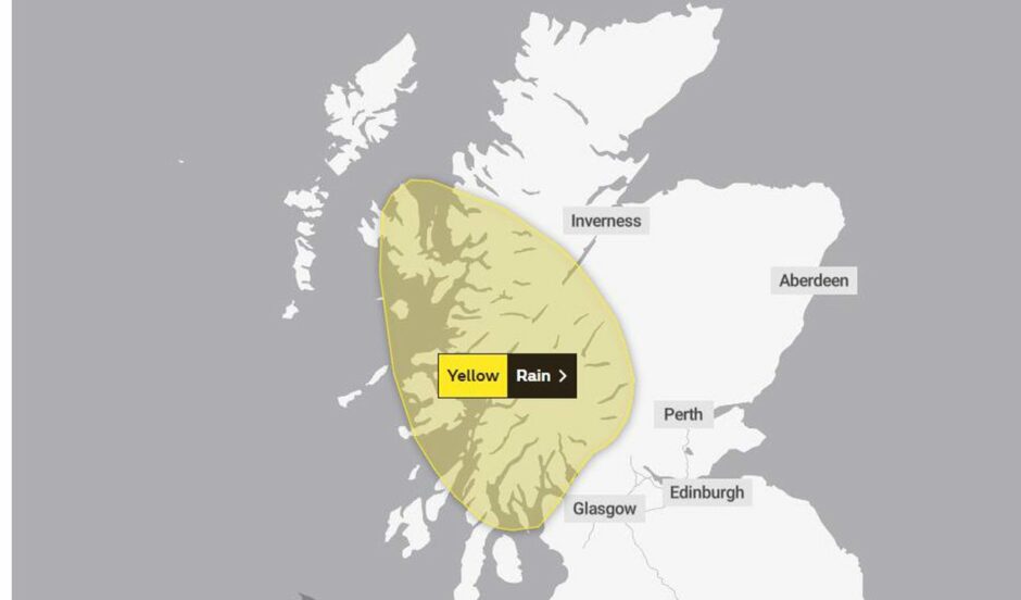
In light of the forecast, Sepa has also issued flood alerts for Argyll and Bute, Skye and Lochaber and Wester Ross.
Network Rail has anticipated disruption and announced it will be limiting train speeds on parts of the Dumfries, West Highland and Kyle lines as a result.
🌧️ Really heavy rain is expected in the west of the country tonight and throughout tomorrow.
Based on the forecast, we’ll be limiting train speeds on parts of the Dumfries, West Highland and Kyle lines for everyone’s safety.
Your journey may take longer. @ScotRail @CalSleeper pic.twitter.com/L9ODl6YiWt
— Network Rail Scotland (@NetworkRailSCOT) October 3, 2022
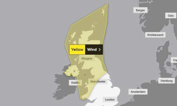
While Tuesday’s warning is localised along the west coast, Wednesday’s spreads across the whole country.
Wednesday winds
Howling winds that are forecast to start at midnight on Tuesday aren’t expected to ease for a whole 24 hours.
The Met Office‘s second yellow weather warning covers the whole of Scotland, including the western and northern isles.
People have been warned there is a chance of flying debris, damage to property and power cuts.
⚠️ Yellow weather warning issued ⚠️
Wind across northern and western parts of the UK
Wednesday 0000 – 2359
Latest info 👉 https://t.co/QwDLMfRBfs
Stay #WeatherAware⚠️ pic.twitter.com/DSrthyXLXR
— Met Office (@metoffice) October 3, 2022
There is also a possibility of disruption to public transport and journey times due to debris on roads.
This comes after a number of CalMac ferry services were cancelled on Monday because of strong sea swells.
Forecast where you are
Tuesday
- Aberdeen – Highs of 15C, lows of 11C, wind gusts up to 37mph
- Fraserburgh – Highs of 15C, lows of 10C, wind gusts up to 38mph
- Inverness – Highs of 16C, lows of 10C, wind gusts up to 37C
- Elgin – Highs of 16C, lows of 10C, wind gusts up to 39mph
- Fort William – Highs of 15C, lows of 11C, wind gusts up to 41mph
- Thurso – Highs of 15C, lows of 9C, wind gusts up to 38mph
- Kirkwall – Highs of 14C, lows of 10C, wind gusts up to 38mph
- Lerwick – Highs of 13C, lows of 11C, wind gusts up to 47mph
Wednesday
- Aberdeen – Highs of 11C, lows of 9C, wind gusts up to 44mph
- Fraserburgh – Highs of 12C, lows of 10C, wind gusts up to 50mph
- Inverness – Highs of 11C, lows of 10C, wind gusts up to 36mph
- Elgin – Highs of 11C, lows of 9C, wind gusts up to 47mph
- Fort William – Highs of 11C, lows of 10C, wind gusts up to 43mph
- Thurso – Highs of 11C, lows of 9C, wind gusts up to 41mph
- Kirkwall – Highs of 11C, lows of 10C, wind gusts up to 41mph
- Lerwick – Highs of 11C, lows of 9C, wind gusts up to 42mph


Conversation